Mid-Columbia: Between Grand Coulee Dam and Bonneville, including the Snake River and its tributaries
The middle section of the river is a large stretch over 450 miles in length, which begins at Grand Coulee Dam at river mile 596 in Washington state, and concludes at Bonneville Dam near river mile 146, where the Columbia serves as the boundary between Oregon and Washington. The Snake River is the largest of the tributaries of the Columbia and once was home to at least a third of the Basin’s salmon run. The Snake River flows in from Idaho and meets the Columbia River at the confluence located near river mile 324.
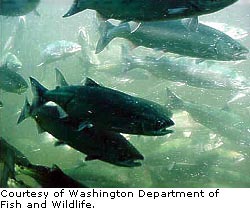
Fish Consumption and Contaminant Survey
In 1991, EPA entered into a two-part agreement with the Columbia River Inter-Tribal Fish Commission (CRITFC)
 and its four member tribes (The Confederated Tribes of the Warm Springs Reservation of Oregon
 , The Confederated Tribes and Bands of the Yakama Nation
 , The Confederated Tribes of the Umatilla Indian Reservation
 , and The Nez Perce Tribe
 ) to better understand the relationship of tribal fishing practices and the likelihood of tribal exposure to environmental contaminants through fish consumption. In the first phase of this agreement, EPA provided a grant to CRITFC for a fish consumption survey.
The Fish Consumption Survey
 was completed in 1994 and documented the amount and types of fish consumed by the four Columbia River Treaty Tribes and demonstrated that the CRITFC tribal members consume higher amounts of fish per capita than the average U.S. citizen. EPA used these results in the revisions to methodology for developing water quality criteria as well as hazardous waste site remediation specifically to derive tribal subsistence ingestion rates.
Oregon Fish Consumption Rate
Working together, the Oregon Department of Environmental Quality (ODEQ), the Confederated Tribes of the Umatilla Indian Reservation (CTUIR) and the Environmental Protection Agency (EPA) are engaging in a process to revise water quality criteria for toxics that would change the current fish consumption rate from 17.5 grams per day.
Tribal fish resources and the health of fish consumers are directly affected by the water quality of Oregon waters. The CTUIR and other regional tribes are known to have consumption rates substantially higher (63.2 – 389 grams per day) from data developed in an EPA funded Columbia River Basin fish consumption survey than the current 17.5 gram per day. In a letter to ODEQ and CTUIR, EPA has suggested that a rate of 105 to 113 grams per day might be more appropriate for some waters in Oregon to protect subsistence fish consumers.
Because so-called fish consumption rates influence water quality standards, the process might result in tougher restrictions on industry and municipalities allowed to discharge pollutants into the state's waterways.
DEQ, EPA and the CTUIR are currently collaborating on a series of workshops beginning in March 2008, to gather information necessary to review the human health criteria with a particular focus on the fish consumption rate. Upon completion of the workshops, an issue paper will be presented to the Oregon Environmental Quality Commission (OEQC). With anticipated public hearings, consideration of public comment, and a fiscal impact statement, all of which are required under state law for rulemaking, a decision by the OEQC to increase the fish consumption rate in the state's Water Quality Standards may not occur until 2009.
Read the Memorandum to the Oregon Environmental Quality Commission
Superfund in the Mid-Columbia
Hanford Nuclear Reservation: The U.S. Department of Energy’s (DOE) Hanford Site located near the City of Richland, Washington, was established to produce nuclear materials for national defense. The Hanford Site was placed on the EPA’s National Priorities List in 1989. DOE entered into the Tri-Party Agreement with EPA and the Washington State Department of Ecology, establishing the legal framework and schedule for the cleanup at Hanford. EPA has an office in Richland, Washington, that provides EPA management of this clean-up effort.
 |  | Revision of Forest And Resource Management Plans
In 2003, with the signing of a Memorandum of Understanding, federal agencies – including the Forest Service, Bureau of Land Management, NOAA Fisheries, US Fish and Wildlife Service, Environmental Protection Agency and the Forest Service’s Forest and Range Experiment Stations – agreed to cooperatively implement the “The Interior Columbia Basin Strategy” to guide the efforts to update land use plans for National Forests and BLM lands in the four-state region. In 2004, the agencies developed an Aquatic/Riparian Habitat Framework to clarify the Interior Columbia Basin Strategy relative to the aquatic and riparian habitat components.
Read the Interior Columbia River Basin Ecosystem Management Project

|
Sediment Study
In 2004, as a follow-up to the EPA Fish Contaminant Study, EPA launched the Mid-Columbia River Sediment Chemical Contaminants Study to spatially characterize the distribution of the contaminants of concern identified through the 2002 EPA Fish Contaminant Survey so that the potential sources could be identified and evaluated. Analyses are completed for the sediment study and a data report is in preparation, to be completed by the end of the year.
| | |
Sediment Management on the Lower Snake River
In addition to hydropower generation, the dams on the Columbia and Lower Snake Rivers created a navigation channel to bring freight to Lewiston, Idaho, 465 miles from the Pacific Ocean. Inland wood and agricultural economies depend on this channel between the four lower Snake River reservoirs (Ice Harbor, Lower Monumental, Little Goose and Lower Granite) and the Columbia River (McNary Reservoir). The reservoirs are formed by slack water pools behind dams, which also trap sediment. Mounting sediment in the navigation channel threatens these economies and fish habitat. Barge loads are sometimes limited by high spots in the river caused by sediment. Excessive sediment can also make it difficult for salmonids to find adequate spawning and resting areas in these reservoirs.
The United States Army Corps of Engineers (USACE) has historically maintained the navigation channel for commercial traffic through dredging. The USACE is developing a broader, watershed-based Programmatic Sediment Management Plan and Environmental Impact Statement (PSMP/EIS) in lieu of a more focused Dredged Material Management Plan (DMMP). The Corps is preparing this multi-year study and data collection effort to evaluate alternatives to dredging at the confluence between the Lower Snake and Clearwater Rivers, and in the four lower Snake River reservoirs. The Corps will conduct a series of public and agency workshops in support of preparing the PSMP/EIS alternatives as part of evaluating the opportunities to reduce sediment input into the rivers, which would reduce the frequency of dredging. At present, the Corps is working to prepare the draft programmatic EIS by 2008 and a final EIS in 2009. EPA is a cooperating agency for this plan.
Learn more about the Corps’ Programmatic Environmental Impact Statement.
 Walla Walla Pesticide Stewardship Partnership
Organophosphate insecticides (OPs) are commonly used in apple orchards and are known to be toxic to fish and other aquatic life. Studies in Oregon fruit growing areas (Hood River and The Dalles) have shown OPs in streams after their use in orchards. Growers have worked successfully to improve water quality through changes in management practices including less toxic insecticides, changes in irrigation practices and Integrated Pest Management (IPM).
Tree fruit growers from the Walla Walla Basin, Oregon State University Extension Service and Washington State University, have been working together to support stewardship of natural resources by implementing practices that reduce the impact of pesticides. In 2005, Oregon Department of Environmental Quality and the WWBWC conducted a pilot study in Milton-Freewater of fruit growers using organophosphate insecticides (OPs). Several organizations have partnered to see if these compounds were reaching surface waters in the Walla Walla River basin, a sub-basin of the Columbia River Basin, during application periods.
No OPs were detected on the main stem of the Walla Walla River, however, some samples from the West Prong of the Little Walla Walla River showed levels sometimes exceeding state water quality standards. The West Prong is not fish-bearing. Future sampling and evaluation of practice alternatives to reduce observed concentrations in the West Prong are planned. Scientists hope the results of future monitoring will guide growers in understanding the relationship between pesticide use and stream water quality.
Columbia Gorge Air Quality Study
In 1986 congress passed the Columbia River Gorge National Scenic Area Act. The Columbia River Gorge National Scenic Area covers approximately 292,500 acres within the 80 mile long Columbia River gorge. The Columbia River Gorge Commission was created to develop and implement policies and programs that protect and enhance the scenic, natural, cultural and recreational resources within the Columbia Gorge.
The Commission works in partnership with a number of entities to implement a regional management plan. The Columbia Gorge Air Quality Study was developed in response to changes made to the regional management plan in May 2000. In May 2000 the commission adopted an amendment to the plan which called for the protection and enhancement of air quality in the Columbia River Gorge NSA. A Technical Foundation study plan was developed to better understand the effects of air pollution on air quality in the Columbia River Gorge NSA. The original study plan was a joint effort between the Southwest Clean Air Agency (SWCAA) in Washington, the Oregon Department of Environmental Quality (ODEQ) and the Washington Department of Ecology (WDOE). The original study plan was redesigned to reflect a reduction in the available funding for the project. The focus of the redesigned study plan is to better understand factors that affect visibility impairment and regional haze in the Columbia River Gorge NSA including identification of sources contributing to visibility impairment in the Scenic Area and the effects of local meterology.
Visit www.gorgeair.org to learn more.
Walla Walla Pesticide Stewardship Partnership
Organophosphate insecticides (OPs) are commonly used in apple orchards and are known to be toxic to fish and other aquatic life. Studies in Oregon fruit growing areas (Hood River and The Dalles) have shown OPs in streams after their use in orchards. Growers have worked successfully to improve water quality through changes in management practices including less toxic insecticides, changes in irrigation practices and Integrated Pest Management (IPM).
Tree fruit growers from the Walla Walla Basin, Oregon State University Extension Service and Washington State University, have been working together to support stewardship of natural resources by implementing practices that reduce the impact of pesticides. In 2005, Oregon Department of Environmental Quality and the WWBWC conducted a pilot study in Milton-Freewater of fruit growers using organophosphate insecticides (OPs). Several organizations have partnered to see if these compounds were reaching surface waters in the Walla Walla River basin, a sub-basin of the Columbia River Basin, during application periods.
No OPs were detected on the main stem of the Walla Walla River, however, some samples from the West Prong of the Little Walla Walla River showed levels sometimes exceeding state water quality standards. The West Prong is not fish-bearing. Future sampling and evaluation of practice alternatives to reduce observed concentrations in the West Prong are planned. Scientists hope the results of future monitoring will guide growers in understanding the relationship between pesticide use and stream water quality.
Columbia Gorge Air Quality Study
In 1986 congress passed the Columbia River Gorge National Scenic Area Act. The Columbia River Gorge National Scenic Area covers approximately 292,500 acres within the 80 mile long Columbia River gorge. The Columbia River Gorge Commission was created to develop and implement policies and programs that protect and enhance the scenic, natural, cultural and recreational resources within the Columbia Gorge.
The Commission works in partnership with a number of entities to implement a regional management plan. The Columbia Gorge Air Quality Study was developed in response to changes made to the regional management plan in May 2000. In May 2000 the commission adopted an amendment to the plan which called for the protection and enhancement of air quality in the Columbia River Gorge NSA. A Technical Foundation study plan was developed to better understand the effects of air pollution on air quality in the Columbia River Gorge NSA. The original study plan was a joint effort between the Southwest Clean Air Agency (SWCAA) in Washington, the Oregon Department of Environmental Quality (ODEQ) and the Washington Department of Ecology (WDOE). The original study plan was redesigned to reflect a reduction in the available funding for the project. The focus of the redesigned study plan is to better understand factors that affect visibility impairment and regional haze in the Columbia River Gorge NSA including identification of sources contributing to visibility impairment in the Scenic Area and the effects of local meterology.
Visit www.gorgeair.org to learn more.
 Bradford Island
PCB clean-up near Bradford Island:
Bradford Island
PCB clean-up near Bradford Island:
 The Oregon Department of Environmental Quality is working with the US Army Corps of Engineers to address various environmental problems on Bradford Island. The island, located near the Oregon side of the Columbia River, is part of the Bonneville Dam facility at Cascade Locks. Electrical components and other debris were dumped into the river at Bradford Island. Some of this equipment contained polychlorinated biphenyls (PCBs) which are highly toxic, do not break down readily, and can bioaccumulate in the food chain. This debris was removed from the river in 2002. Contaminated sediment was removed from the river bottom using diver-assisted suction dredging in October 2007. Additional testing in the river and on the island continues as part of the ongoing remedial investigation.
Total Maximum Daily Loads (TMDLs) for the Mid-Columbia
In order to meet Water Quality Standards, there are several TMDLs for the middle section of the river basin:
The Oregon Department of Environmental Quality is working with the US Army Corps of Engineers to address various environmental problems on Bradford Island. The island, located near the Oregon side of the Columbia River, is part of the Bonneville Dam facility at Cascade Locks. Electrical components and other debris were dumped into the river at Bradford Island. Some of this equipment contained polychlorinated biphenyls (PCBs) which are highly toxic, do not break down readily, and can bioaccumulate in the food chain. This debris was removed from the river in 2002. Contaminated sediment was removed from the river bottom using diver-assisted suction dredging in October 2007. Additional testing in the river and on the island continues as part of the ongoing remedial investigation.
Total Maximum Daily Loads (TMDLs) for the Mid-Columbia
In order to meet Water Quality Standards, there are several TMDLs for the middle section of the river basin:
- Total Dissolved Gas and Dioxin on the main stem.
- Temperature, Total Dissolved Gas, DDT, DDD, DDE and Dieldrin and Phosphorus, Sediment and Dissolved Oxygen for the Snake River (Hells Canyon Subbasin) and Total Dissolved Gas for the Lower Snake River.
- Temperature for the Upper Yakima River as well as Suspended Sediment and DDT and Suspended Sediment, Turbidity and Organochlorine for the Lower Yakima.
- Chlorinated Pesticide and PCB, Temperature, and Conventional in the Walla Walla Subbasin.
- Temperature and Turbidity for the Umatilla Subbasin.
- Upper Grande Ronde Subbasin for Temperature and Peryphiton
Learn more about TMDLs in the Columbia Basin