The "Wolverine Creek near Lawing" stream-gaging station, USGS station
15236900,
is part of the USGS network of nearly 100 stations in Alaska. Data collection and analysis
are conducted by standard techniques developed by the USGS. Daily values of discharge are
generally reported along with those for the rest of Alaska in annual publications of the
USGS Water-Data Report series, and available on-line (see links below).
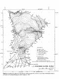 |
| Basin map, click on image for
enlargement, 105KB. |
Location: Lat 60°22'14"N., Long 148°53'48"W., 370 m altitude, in
NE 1/4 sec.10, T.3 N., R.3 E., Hydrologic Unit 19020202, on left bank about
0.15 km downstream
from terminus of Wolverine Glacier and 25 km east of Lawing, Alaska.
(Click on map thumbnail to right for large basin map, 105 Kbytes.)
Drainage area: 24.5 km2.
Period of record: October 1966 to September 1978, October 1980 to September
1981, May 1997 to September 1997, October 2000 to current.
