ABOUT TSUNAMIS
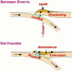
When a subduction zone ruptures in a great earthquake, it causes upheaval of huge blocks of land on the ocean
floor. This motion drives the overlying water column, causing tsunamis. Waves of water travel out in
both directions. Multiple waves alternate with sudden withdrawls of water. These waves inundate nearby coast within minutes, and also travel across the ocean striking distant areas many hours later. Tsunami travel time maps show the expected travel times across the Pacific Ocean.
Since 1987, when Brian Atwater of the USGS first reported finding
evidence for repeated subsidence of coastal lowlands in Washington, scientists
have searched for further geologic traces of great subduction earthquakes
in the Northwest. Shortly after Atwater's discovery, researchers found evidence of a great
tsunami in sand deposits along coastal areas of the Northwest.
Joanne Bourgeois, a researcher from the University of Washington, reported
that sand sheets covering the buried wetlands along coastal Washington
and Oregon closely resemble sand sheets deposited on lowlands of southern
Chile by the great tsunami that followed the 1960 Chilean earthquake. Mary Reinhart,
also from the University of Washington, studied the thickness of the Washington
sand deposits and concluded that they are the result of what was likely
a 10 meter tsunami along Washington’s coast.
These
sand sheets are layers of ocean sand
in between layers of soil and mud. Atwater, Bourgeois, Rinehart and others believe that these sand
sheets were created when a series of tsunami waves washed over subsided
regions of the coastline and deposited sand, which later became covered over in
mud.
Researchers considered the possibility that these sand deposits might be the result of nonseismic processes such as storms. However, Bourgeois and Reinhart's
studies of these buried sediments and computer generated model simulations
concluded that gigantic waves are the best explanation.
Printable Versions |
References