Glacier and Landscape Change in Response to Changing Climate
|
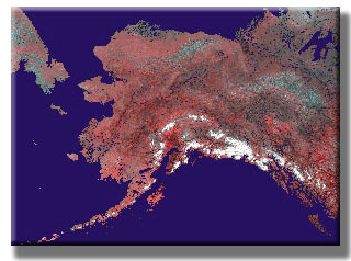
Glaciers cover about 75,000 square kilometers (about 28,957 square miles) of Alaska, or more than 5% of the State. They occur on about a dozen different mountain ranges and on three island areas. The number of Alaskan glaciers is unknown, having never been systematically counted, but probably exceeds 100,000. About 2,000 are valley glaciers that descend to elevations below a mile. Since the 1890s, about 700 glaciers have been officially named by the U.S. Board on Geographic Names. Alaska's glaciers range in size from tiny cirque glaciers (< one square kilometer or about 0.6 square miles) to massive piedmont glaciers such as Bering Glacier and Malaspina Glacier (each > 5,000 square kilometers or about 1,931 square miles), each larger than the State of Rhode Island.
The area of Alaska's glaciers is:
In recent years, many glacier changes have been quite dramatic. Although a few glaciers are advancing, at lower elevations, more than 98 % of Alaska's large, lower elevation glaciers are in retreat, thinning, or stagnating. In 2008, the USGS released a comprehensive summary of the behavior of Alaskan glaciers. For details visit the USGS Newsroom: Most Alaskan Glaciers Retreating, Thinning, and Stagnating, Says Major USGS Report.
For access to the entire document, or for more information see: Professional Paper 1386K, Satellite Image Atlas of Glaciers of the World – Alaska |
Glacier Home Page ||
Weather and Climate ||
Water on Earth ||
Introduction to Glaciers ||
Monitoring Earth's Glaciers ||
Glaciers and Sea Level ||
Glaciers of Alaska ||
Repeat Photography ||
Frozen in Time? ||
Additional Information

![]() U.S. Department of the Interior |
U.S. Geological Survey
U.S. Department of the Interior |
U.S. Geological Survey
URL: http://www.usgs.gov/global_change/glaciers/glaciers_alaska.asp
Page Contact Information: Ask USGS
Page Last Modified: Friday, December 05, 2008