| CLEAN
AIR ACT BACKGROUND
Congress recognized visibility, defined
as "the appearance of scenic features when viewed from
a distance," as a resource to be valued and preserved.
Specifically, Section 169A of the 1977 amendments to the Clean
Air Act required the Environmental Protection Agency (EPA)
to promulgate regulations to assure reasonable progress toward
the congressionally declared National Goal of "the prevention
of any future, and the remedying of any existing, impairment
of visibility in mandatory Class I federal areas which impairment
results from man-made air pollution." The intent
of Congress to protect visibility was further strengthened
in Section 169B of the 1990 Clean Air Act Amendments.
The EPA has promulgated regulations to ensure that ongoing
efforts are made to protect visual air quality.
To effectively track progress toward meeting
the National Goal, numerous federal, state, tribal, and local
visibility monitoring sites and monitoring programs have been
established. |
NATIONAL
AIR PROGRAMS
In 1978, the U.S. Forest Service Air Monitoring
Program was established to protect all Forest Service managed
lands from the adverse effects of air pollution. In
1988, the U.S. Forest Service became a primary participant
in the national visibility monitoring program titled Interagency
Monitoring of Protected Visual Environments (IMPROVE).
The objectives of the Program are to:
•Establish current visibility and
aerosol conditions in mandatory Class I areas.
•Identify chemical species and emission
sources responsible for existing human-made visibility impairment.
•Document long-term trends for assessing
progress towards the national visibility goals.
•With the enactment of the Regional
Haze Rule, to provide regional haze monitoring representing
all visibility-protected federal Class I areas where practical.
Data collected at these sites are used
by land managers, industry planners, and air quality regulators
to understand and protect the visual air quality resource
in Class I areas. Most importantly, the IMPROVE Program
scientifically documents for American citizens, the visual
air quality of their wilderness areas and national parks. |
VISIBILITY
MONITORING APPROACHES
A variety of monitoring techniques exist
to document visibility conditions and to make quantitative
measurements of the atmospheric properties that effect visibility.
The IMPROVE Program (Interagency Monitoring of Protected Visual
Environments) has partitioned visibility-related characteristics
and measurements into three groups:
Aerosol: the physical properties
of the ambient atmospheric aerosols (chemical composition,
size, shape, concentration, temporal and spatial distribution,
and other physical properties) through which a scene is viewed.
Fine particle measurements are commonly made to quantify aerosol
characteristics.
Optical: the ability of the atmosphere
to scatter or absorb light passing through it. Extinction,
scattering, and absorption coefficients, plus an angular dependence
of the scattering, known as the scattering phase function,
describe the physical properties of the atmosphere.
Optical characteristics integrate the effects of atmospheric
aerosols and gases. Commonly applied optical monitoring
instruments include transmissometers and nephelometers.
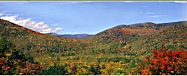
Scene: the appearance of a scene
viewed through the atmosphere. Scene characteristics
include observer visual range, scene contrast, color, texture,
clarity, and other descriptive terms. Scene characteristics
change with illumination and atmospheric composition.
Photographs, video images, and digital images are effective
ways to document scene characteristics. |