weather.gov
National Weather Service
Tampa Bay Area, FL
En Español
Home
News
Organization
Search
Spot Forecast/Request: Click
Here
.
For Help on How to Use: Click
Here
.
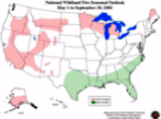
Monthly Wildland
Fire Outlook
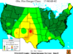
Observed
Fire Danger Class
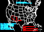
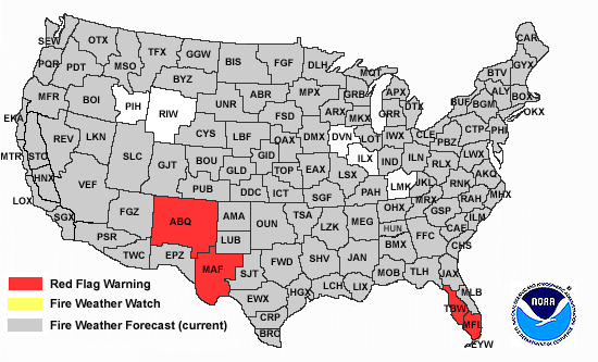
Fire Weather Outlook
Day 1
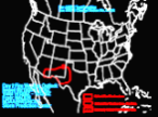
Fire Weather Outlook
Day 2
Fire Weather Maps
NIFC Fire Maps
NOAA Fire Maps
Florida Fire Events
Weekly Precip Map
Wildland Fire Assessment Maps
Lightning Detection
US Drought Monitor
Other Links
National Incident Management
Situation Report
Regional Fire Weather Page
National Interagency Fire Center
Southern Area Coordination Center
Geospatial Multi-Agency Coordination
Fire and Aviation Management
Operating Plan
Florida Fire Weather Operating Plan
Latest Observations
Regional Weather Roundup
Florida Automated Weather Network Observations
Current Imagery Links
Florida Fire Satellite Monitoring
Florida Division of Foresty
Keetch-Byram Drought Index
Forestry Fire Management Information System (FMIS) Mapping Tool
Local weather
forecast by "City, St"
or zip code
Current Hazards
Local Graphical
National
Current Conditions
Observations
Satellite Images
Rivers/Lakes AHPS
Precip Estimate
Local Beaches
El Niño/La Niña
Hydrology
Radar Imagery
Local
Region
Nationwide
Forecasts
West Central Florida
Aviation
Marine
Fire Weather
Activity Planner
Climate
Local
Local Enhanced
National
Tropical Weather
West Central Florida
Graphical Tropical
Hurricane Center
Weather Safety
Preparedness
Skywarn ™
NOAA Weather Radio
Additional Info
About Us
Storm Surveys
News Letters
Local Research
Numerical Models
EM and Media
Online School
Contact Us
Send Storm Report
Ask Questions
Offices In Florida
Phone Numbers