|
 |
| About Skywarn™... |
| The National Weather Service modernized during the 1990s, with
technological advances and employee training greatly improving the warning process. |
|
|
| While changes have taken place, some things have remained the same.
Skywarn™ has been around for several decades, and is valuable when severe weather
threatens. |
| |
| Each year, the value of this program is celebrated during Skywarn™ Recognition
Day. For more details, click here. |
| |
| Read about Skywarn™ and other topics below... |
|
|
| Skywarn™ (formed in
the early 1970s) is the National Weather Service (NWS) program of trained volunteer severe
weather spotters. Skywarn™ volunteers support their local community and
government by providing the NWS with timely and accurate severe weather reports. These
reports, when integrated with modern NWS technology, are used to inform communities of
approaching severe weather. The focus of Skywarn™ (and of the NWS) is simple...to save
lives and property. |
 |
For a long time, the NWS has relied on radar data when issuing warnings.
|
| Since the early 1990s, the WSR-88D (Doppler
Weather Radar) has provided valuable information to forecasters...with better detection of
severe storm phenomena and more accurate and timely warnings. |
| However, even with the advance in technology..."ground
truth" is still a very important part of the warning process.
"Ground truth" answers what exactly is going on. Is the storm
tornadic? Is it producing large hail? How about damaging winds? Most of
the "ground truth" is provided by trained storm spotters (through Skywarn™)...or
the "eyes of the NWS." |
| The NWS believes so much in storm spotters
(and Skywarn™) that it provides continuous training. The students are
members of law enforcement, emergency management, HAM radio clubs, and are also ordinary
citizens who just want to help. All that is necessary is to spend a few hours
learning about severe weather...what a severe storm is, the structure of a severe storm,
how it develops, and how to inform the NWS of severe weather. |
| The course has mostly been computerized...and is presented in a multimedia
format. |
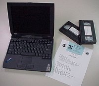 |
| Many visuals and animations are provided to make the material easier to
understand. There is a little paperwork and a few videos as well. |
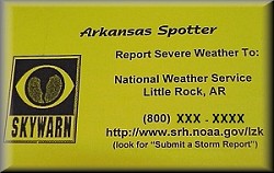 |
Students are provided with a card (to left) that contains spotter tips and
how to contact the NWS. |
| At the completion of the course, students are given certificates which
make them official NWS storm spotters for five years. |
| The course is normally taught by the Warning Coordination Meteorologist
(WCM) from a local NWS office. The WCM helps develop the coursework and is the
liason between storm spotters and the NWS. |
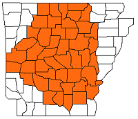 |
| Courses through the NWS Forecast Office in Little Rock are offered in 45
counties... namely the office's County Warning Area (CWA). For a
closer look at CWAs across Arkansas, click on the links
below: |
| |
| Graphical |
Text |
|
|
| To become a trained storm spotter, you must
complete the coursework provided by the NWS. The NWS often works with
county emergency managers and officials to plan classes, with numerous classes given each
year. Currently, there are ten (10) classes scheduled. |
|
| Conway (Faulkner Co.) |
| Date: March 12, 2009 (Thursday) |
| Time: 6:30 pm |
| Place: New Office of Emergency Management
Building, 57 Acklin Gap Road (just off U.S. 65 North) |
|
| Hot Springs (Garland Co.) |
| Date: March 14, 2009 (Saturday) |
| Time: 8:00 am |
| Place: National Park Community College, New Lab/Science
Building, Room 118 |
|
| Pine Bluff (Jefferson Co.) |
| Date: March 16, 2009 (Monday) |
| Time: 6:00 pm |
| Place: Donald W. Reynolds Center |
|
| Paris (Logan Co.) |
| Date: March 17, 2009 (Tuesday) |
| Time: 6:30 pm |
| Place: Emergency Management Building, 205 East Maple |
|
| Harrison (Boone Co.) |
| Date: March 19, 2009 (Thursday) |
| Time: 6:30 pm |
| Place: RSVP Building (behind Edwards Grocery) |
|
| Mena (Polk Co.) |
| Date: April 7, 2009 (Tuesday) |
| Time: 6:00 pm |
| Place: Rich Mountain Community College (1100 College Drive) in the Lecture Hall |
|
| Russellville (Pope Co.) |
| Date: April 9, 2009 (Thursday) |
| Time: 6:00 pm |
| Place: To be announced |
|
| Augusta (Woodruff Co.) |
| Date: April 13, 2009 (Monday) |
| Time: 6:30 pm |
| Place: Courthouse |
|
| Mountain View (Stone Co.) |
| Date: April 16, 2009 (Thursday) |
| Time: 6:30 pm |
| Place: Stone County Fairgrounds |
|
| Brinkley (Monroe Co.) |
| Date: April 23, 2009 (Thursday) |
| Time: 7:00 pm |
| Place: Courtroom at City Hall |
|
|
| Classes
are subject to postponement if severe weather occurs on the day of the class, or if the NWS is involved with
storm surveys following large severe weather outbreaks. |
|
| For Skywarn™ to work, it is crucial for reports to make it from storm
spotters to the NWS. The easiest way to make contact is by phone through a special
800 number. |
| Also, during many severe weather events...reports can be submitted through
HAM radio. |
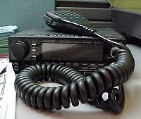 |
| The Arkansas
Weather Net, Inc. often provides its services at the NWS...with reports immediately
relayed from HAM operators to radar operators. |
| Reports can also be filed at this web site through a special
"Weather Reporting Form." To see this form, click here. |
| Obviously, the reports go to the NWS. They are used both during and
after severe weather events. During the events, the reports help radar operators
determine what a storm is producing so they can warn counties farther downstream.
After the events, the reports are used for studies. Quite often, reports are
correlated with radar data to help measure the performance of the radar and to help
forecasters interpret the data. In the end, forecasters end up becoming better radar
operators. |
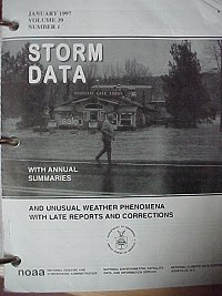 |
Reports are also compiled in a monthly publication called "Storm Data." |
| Skywarn™ involves
getting yourself trained to identify and report severe weather. |
|
| StormReady goes one step further,
training communities how to prepare for severe weather.
|
 |
| Is your community StormReady? If you're not sure, or you would like to learn more about StormReady...click
here. |
|
| StormReady Communities in the
Little Rock County Warning Area |
| Lonoke County (02/19/2009) |
| Danville (09/18/2008) |
| Johnson County (08/20/2008) |
| Grant County (08/07/2007) |
| Jackson County (06/20/2001) |
| Hot Springs/Garland County
(05/07/2001) |
|
|
|