| |
||||||||
|
||||||||
Article |
||
| The North America Tapestry of Time and Terrain | ||
|
|
|
| Introduction to a Tapestry of Time and Terrain | ||
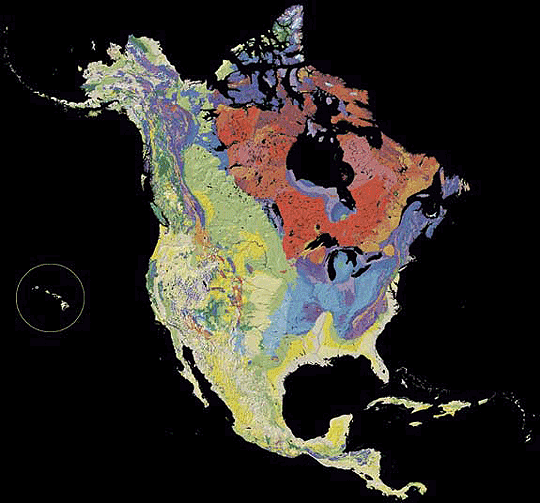
| The North America Tapestry of Time and Terrain is woven from a geologic map and a shaded relief image. This digital combination reveals the geologic history of North America through the interrelation of rock type, topography and time. Regional surface processes as well as continent-scale tectonic events are exposed in the three dimensions of space and the fourth dimension, geologic time. This map is an expansion of the original United States Tapestry of Time and Terrain, produced in 2000.
On the Two Maps page, you can
view the two component maps separately, the geologic map and the
shaded relief map. If you want to get a better look at different parts of the map, visit the Zoom In section. Throughout the continent, there are important and unique geological features. The Features page lets you click around and learn more about the regional and local details of the Tapestry. One of the key aspects of the Tapestry its display rock ages. The Legend and Rock Ages section lets you see where rocks of specific ages are distributed on the continent. Another important rock characteristic, one not displayed on the main Tapestry map, is the Rock Type. Explore this section to see where different types of rock (sedimentary, volcanic, plutonic and metamorphic) are found in North America. We have also put political boundaries on the map in the Political Boundaries section. There the Tapestry is divided into four sections: Canada, the Caribbean, Mexico and Central America, and the United States. |
||
| back
to top |
||
| Credits | ||
| This Web site is a companion to the United States Geological Survey (USGS) printed product Geologic Investigations Series I-2781, The North America Tapestry of Time and Terrain. Information on ordering the map , as well as downloadable PDF files, can be found here. The North America Tapestry was produced at the USGS by Kate Barton, David Howell, and Joe Vigil in cooperation with the Geological Survey of Canada and Mexico's Consejo Recursos de Minerales . The geologic data were generalized from the Decade of North American Geology Geologic Map of North America compiled by John C. Reed (USGS) and John O. Wheeler (Geological Survey of Canada), sponsored by the Geological Society of America. Processing and reprojection of the geologic data were done in ArcINFO GIS. The underlying cartographic structure is a shaded relief map derived from a 1-kilometer digital elevation model (DEM). John Hutchinson (EROS Data Center) supplied the original DEM. The projection used is Lambert Azimuthal Equal Area. The two component maps were georeferenced to one another using GIS software and the final images were combined using graphics software. This Web site was produced at USGS, Menlo Park, California, in 2003 by Timothy Lesle with Kate Barton. Just as the North America Tapestry map is a continuation of the original Tapestry of Time and Terrain map of the United States (which can be downloaded here), this site owes much to Eleanore Jewel's popular companion Web site A Tapestry of Time and Terrain: The Union of Two Maps - Geology and Topography. |
||
| back
to top |
||