Glacier and Landscape Change in Response to Changing Climate
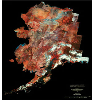 |
| Landsat MSS false-color infrared image mosaic of part of Alaska, showing most of the glacierized areas in Alaska except for the southeastern panhandle of the state and the westernmost part of the Aleutian Islands including many of the active and former tidewater glaciers. (High Resolution image) |
In 1978, the USGS began the preparation of the 11-chapter USGS Professional Paper 1386, "Satellite Image Atlas of Glaciers of the World." The purpose of the Atlas is to present a thorough global baseline study of the areal extent of existing glaciers, so that future scientists can assess the magnitude of glacier change that is forecast to occur worldwide during the 21st century.
Satellite images [Landsat 1, 2, and 3 multispectral scanner (MSS) images and Landsat 2 and 3 return beam vidicon (RBV) images] are used to inventory the areal occurrence of glacier ice on our planet within the boundaries of the spacecrafts' coverage (between about 82° north and south latitudes). Some later contributors also used Landsat 4 and 5 MSS and Thematic Mapper, Landsat 7 Enhanced Thematic Mapper-Plus (ETM+), and other satellite images.
The Atlas will provide an accurate regional inventory of the areal extent of glaciers on our planet during a relatively narrow time interval (1972 - 1981). This global "snapshot" of glacier extent is already being used for comparative analysis with previously published maps and aerial photographs, as well as with new maps, satellite images and aerial photographs, to determine the areal fluctuation of glaciers in response to natural or human-induced changes in the Earth's climate.
For more information see the U.S. Geological Survey Fact Sheet 2005-3056: Satellite Image Atlas of Glaciers of the World.Glacier Home Page ||
Weather and Climate ||
Water on Earth ||
Introduction to Glaciers ||
Monitoring Earth's Glaciers ||
Glaciers and Sea Level ||
Glaciers of Alaska ||
Repeat Photography ||
Frozen in Time? ||
Additional Information

![]() U.S. Department of the Interior |
U.S. Geological Survey
U.S. Department of the Interior |
U.S. Geological Survey
URL: http://www.usgs.gov/global_change/glaciers/monitoring_glaciers.asp
Page Contact Information: Ask USGS
Page Last Modified: Thursday, December 04, 2008
