|
|
 |
|
 |
|
Soils Home
|
|
|
|
|
Soil Survey Manual - Appendix 1Three appendices are included. The first gives examples of descriptions of soil series. The second describes three map units that are quite different in their systematics. The third appendix contains point information for soils of the three map units.
Series DataTable of Contents
Sharpsburg Official Soil Series DescriptionThe Sharpsburg series consists of deep, moderately well drained soils formed in loess on uplands. Permeability is in the moderately high saturated hydraulic conductivity class. The lower part of the subsoil is more permeable than the upper part. Slope ranges from 0 to 18 percent. Mean annual temperature is about 11 °C, and mean annual precipitation is about 750 mm. Taxonomic Class: Fine, montmorillonitic, mesic Typic Argiudolls Representative Pedon: Sharpsburg silty clay loam with a convex slope of 8 percent-cultivated. Colors are for moist soil unless otherwise stated. Ap—0 to 20 cm; black (10YR 2/1) silty clay loam, dark grayish brown (10YR 4/2) dry; weak fine subangular blocky structure; friable; few fine roots; slightly acid; abrupt smooth boundary. A1—20 to 28 cm; very dark brown (10YR 2/2) silty clay loam, dark grayish brown (10YR 4/2) dry; moderate very fine subangular blocky structure; friable; slightly acid; clear smooth boundary. A2—28 to 43 cm; very dark grayish brown (10YR 3/2) silty clay loam, grayish brown (10YR 5/2) dry; some brown (10YR 4/3) peds; moderate very fine subangular blocky structure; friable; moderately acid; gradual smooth boundary. Combined thickness of the A horizons is 25 to 60 cm. Bt1—43 to 61 cm; brown (10YR 4/3) silty clay loam; very dark gray (10YR 3/1) coatings on faces of peds; moderate fine subangular blocky structure parting to weak fine subangular blocky; firm; common distinct very dark grayish brown (10YR 3/2) clay films; very few fine roots; moderately acid; gradual smooth boundary. Bt2—61 to 79 cm; brown (10YR 4/3) and yellowish brown (10YR 5/4) silty clay loam; few fine prominent light brownish gray (2.5Y 6/2) mottles; weak medium prismatic structure parting to moderate fine subangular blocky; firm; many distinct dark grayish brown (10YR 4/2) clay films; very few fine and medium roots; few fine dark concretions (iron and manganese oxides); moderately acid; gradual smooth boundary. Bt3—79 to 97 cm; brown (10YR 5/3) silty clay loam; common medium distinct light brownish gray (2.5Y 6/2) and strong brown (7.5YR 5/6) mottles; weak medium prismatic structure parting to weak medium subangular blocky; friable; many prominent grayish brown (10YR 5/2) clay films; few fine dark concretions (iron and manganese oxides); moderately acid; gradual smooth boundary. Combined thickness of the Bt horizons is 53 to 97 cm. BC—97 to 117 cm; yellowish brown (10YR 5/4) silty clay loam; many fine and medium distinct grayish brown (2.5Y 5/2) and common medium prominent strong brown (7.5YR 5/8) mottles; weak medium prismatic structure; firm; common distinct grayish brown (10YR 5/2) clay films; few fine dark concretions (iron and manganese oxides); moderately acid; gradual smooth boundary. (10 to 25 cm thick) C—117 to 152 cm; mottled grayish brown (2.5Y 5/2), yellowish brown (10YR 5/4), strong brown (7.5YR 4/4) silty clay loam; massive; firm; very few fine roots; common fine dark concretions (iron and manganese oxides); slightly acid. Type Location: Taylor County, Iowa; about 13 km north and 8 km east of Bedford; 570 m east and 165 m south of the northwest corner, sec. 10, T. 69 N., R. 33 W. Range in Characteristics: Solum thickness typically is 90 to 180 cm thick. Thickness of the A horizon, depth to clay maximum, maximum percent clay, thickness of the Bt horizon, depth to grayish mottles, and solum thickness decrease as gradient increases on convex slopes. The solum is moderately acid or strongly acid in the most acid part. The Ap horizon has value of 2 or 3 and chroma of 1 or 2. The A1 and A2 horizons have value and chroma of 2 or 3. The A horizon ranges from 25 to 34 percent clay. The upper part of the Bt horizon has value of 4 or 5, and chroma of 3 or 4 and contains 36 to 42 percent clay. Pedons having colors in the matrix of 5 or 6 value and 2 chroma at depths of less than 80 cm are outside the range. The lower part of the Bt horizon, the BC horizon, and the C horizon have hue of 7.5YR to 5Y, value of 4 through 6, and chroma of 2 through 6. The C horizon is silty clay loam or silt loam. Competing Series: These are the Gymer, Oska, and Polo series. Similar soils are the Grundy, Macksburg, and Wymore soils. Gymer and Oska soils have 7.5YR or 5YR hue in the Bt horizon. In addition, Oska soils have a lithic contact within depths of 100 cm. Polo soils have 7.5YR and 5YR hue in the lower part of the B horizon. Grundy and Macksburg soils have lower chroma, mottles, or both in the upper part of the B horizon. Also, Grundy soils have 42 to 48 percent clay in the upper 50 cm of the argillic horizon. Wymore soils have 2.5Y or yellower hue, dominant chroma of 2 in the B horizon, and contain more clay. Geographic Setting: Sharpsburg soils are on convex ridgetops, and convex side slopes, and on high benches. Typically, they are on narrow ridgetops having slopes of 2 to 9 percent gradient. The full range of slope is from 0 to 18 percent. Sharpsburg soils formed in 2 to 5 meters of loess that contains less than 5 percent sand. Mean annual temperature ranges from about 8 to 14 °C and mean annual precipitation ranges from about 700 to 800 mm. Geographically Associated Soils: The somewhat poorly drained Macksburg soils and the poorly drained Winterset soils form a drainage sequence with the Sharpsburg soils and commonly are on the more nearly level parts of the landscape. Adair, Clarinda, Lamoni, Pawnee, and Shelby soils are on adjoining lower parts of the landscape. They formed in till or in paleosols formed in till. Judson, soils are on foot slopes downslope and formed in local colluvium. Clearfield, and Nira, soils are nearby at about the same elevations and have a grayish B horizon. Drainage and Permeability: Moderately well drained. Surface runoff is medium to rapid (Soil Survey Staff, 1951). Permeability (saturated hydraulic conductivity) is in the lower half of moderately high in the upper part of the subsoil and in the upper half of moderately high in the lower part and in the substratum. Use and Vegetation: Commonly used for growing cultivated crops. Corn (Zea mays L.), soybeans (Glycine max (L.) Merr), small grains, and hay are grown. Native vegetation was tall prairie grasses. Distribution and Extent: Southwestern Iowa, northwestern Missouri, northeastern Kansas, and southeastern Nebraska. The soils are extensive. Series Established: Lancaster County, Nebraska, 1944. Remarks: Diagnostic horizons and features recognized in this pedon are: mollic epipedon"the zone from the surface to a depth of 43 cm (Ap, A1, and A2 horizons); argillic horizon"the zone from 43 cm to a depth of 97 cm (Bt1, Bt2, and Bt3 horizons); udic moisture regime. Click links to see Sharpsburg Series Soil Interpretations
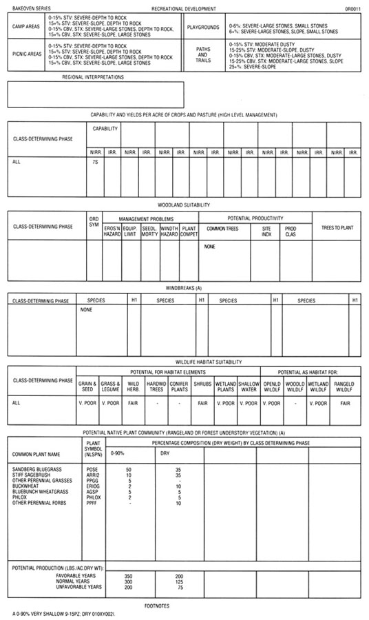
Record Bakeoven Official Soil Series DescriptionThe Bakeoven series consists of very shallow, well drained soils that formed in mixed alluvium, loess, and residuum weathered from basalt. Bakeoven soils are on uplands and have slopes of 0 to 90 percent. The mean annual precipitation is about 330 mm and the mean annual temperature is about 9 °C. Taxonomic Class: Loamy-skeletal, mixed, mesic Lithic Haploxerolls Representative Pedon: Bakeoven very cobbly loam-rangeland. Colors are for dry soil unless otherwise noted. A—0 to 5 cm; brown (7.5YR 5/3) very cobbly loam, dark brown (7.5YR 3/2) moist; weak thin platy and weak fine granular structure; slightly hard, friable, slightly sticky and slightly plastic; common very fine roots; many very fine irregular pores; about 40 percent by volume of rock fragments; slightly acid (pH 6.5); abrupt smooth boundary. (0 to 10 cm thick) Bw1—5 to 10 cm; brown (7.5YR 5/3) very gravelly heavy loam, dark brown (7.5YR 3/3) moist; weak thin platy and weak fine and medium granular structure; slightly hard, friable, sticky and plastic; common very fine roots; common very fine irregular pores; about 60 percent by volume of rock fragments; neutral (pH 6.8); abrupt smooth boundary. (5 to 15 cm thick) Bw2—10 to 18 cm; brown (10YR 5/3) very gravelly clay loam, dark brown (10YR 3/3) moist; moderate fine subangular blocky structure; hard, friable, sticky and plastic; common very fine roots; common very fine tubular pores; about 60 percent by volume of rock fragments; neutral (pH 6.9); abrupt wavy boundary. (2 to 10 cm thick) 2R—18 cm; basalt. Type Location: Wasco County, Oregon; 360 m south and 30 m east of center of sec. 7; NW1/4, SE1/4 sec. 7. T. 8 S., R. 15 E. Range in Characteristics: The soil is dry throughout above the lithic contact for more than half the time (cumulative) that the soil temperature is above 5 °C. The mean annual soil temperature ranges from 8 to 12 °C. Thickness of solum and depth to bedrock range from about 10 to 25 cm. Rock fragments commonly range from 50 to 90 percent, but the upper 5 to 10 cm of the deeper sola have as little as 35 percent. Organic matter ranges from 1 to 2 percent. The deeper part of some sola have coatings of carbonates on the underside of rock fragments and these coatings extend in cracks into the underlying rock. The sola have 10YR, 7.5YR, or 5YR hue. The A horizon has value of 4 or 5 dry, 2 or 3 moist and chroma of 2 or 3 moist and 2 through 4 dry. It is slightly acid to mildly alkaline. The B horizon has the same color value as that of the A horizon and chroma is 2 or 3 in the upper part and 3 or 4 below depths of 15 or 18 cm in sola thicker than 18 cm. It is loam, clay loam or silt loam and averages more than 18 percent clay and has more than 35 percent rock fragments. This horizon has moderate fine subangular blocky through weak medium subangular blocky structure. It is slightly acid to mildly alkaline. Clay films are present on some rock fragments in deeper sola or in the fractures in the underlying bedrock. Competing Series: These are the Aldax, Bodell, Couleedam, Johntom, Lickskillet, Limekiln, Plaskett, and Venator series. All of these soils are deeper than 25 cm to bedrock. Aldax and Plaskett soils have less than 18 percent clay in the particle-size control section. Limekiln soils have a calcic horizon. Plaskett soils have mean annual soil temperature of 13 to 15 °C. Geographic Setting: The Bakeoven soils are on ridge tops, hillslopes and benches at elevations of 180 to 1600 meters. Slopes of 2 to 20 percent are most common and the full range is from about 0 to 90 percent. The soils formed in loess and residuum weathered from basalt. The climate is semiarid. The mean annual precipitation ranges from 25 to 40 cm, the mean annual temperature is from 7 to 11 °C, the mean winter temperature is from 7 to 11 °C, and the mean summer temperature is from 17 to 19 °C. The frost-free period is 100 to 165 days. Geographically Associated Soils: These are the competing Lickskillet soils and the Anderly, Agency, Cantala, Condon, Gem, Maupin, Morrow, Reywat, Ritzville, Ruckles, Starbuck, Walla Walla, Wapinitia, Watama and Wrentham soils. Agency soils are moderately deep to bedrock and have less than 35 percent rock fragments. Anderly and Condon soils are moderately deep and formed in loess over bedrock and in many places are "biscuits" associated with Bakeoven soils. Cantala soils are fine-silty and deeper than 1 m to bedrock. Gem and Morrow soil have an argillic horizon and are moderately deep to bedrock. Maupin soils have a duripan and are fine-loamy. Reywat soils are shallow and have a skeletal argillic horizon. Ritzville and Walla Walla soils are deep or very deep, formed in loess, and are free of rock fragments. Ruckles soils have a very stony argillic horizon. Starbuck soils are on steep south-facing slopes, lack a mollic epipedon, formed mostly in loess, and contain less than 35 percent rock fragments. Wapinitia soils are deep and have an argillic horizon. Watama soils are moderately deep and are fine-loamy. Wrentham soils are on steep north-facing slopes and are deeper than 50 cm to bedrock. Drainage and Permeability: Well drained; medium runoff (Soil Survey Staff, 1951); moderately slow permeability and in the moderately high saturated hydraulic conductivity class. In a few places, the soil is ponded for short periods. Use and Vegetation: Most of the soil is used for range. Native vegetation is bunchgrasses, forbs, and shrubs. Distribution and Extent: North-central Oregon, eastern Washington, and southwestern Idaho. This series is extensive. Series Established: Sherman County, Oregon; 1962. Click links to see Bakeoven Series Soil Interpretations
Record Condon Official Soil Series DescriptionThe Condon series consists of moderately deep, well drained soils that formed in loess overlying basalt. Condon soils are on uplands and have slopes of 0 to 40 percent. Mean annual precipitation is about 300 mm and the mean annual temperature is about 9 °C. Taxonomic Class: Fine-silty, mixed, mesic Typic Haploxerolls Representative Pedon: Condon silt loam-cultivated. Colors are for dry soil unless otherwise noted. Ap—0 to 18 cm; grayish brown (10YR 5/2) silt loam, very dark brown (10YR 2/2) moist; weak medium platy and weak medium granular structure; slightly hard, friable, slightly sticky and slightly plastic; many very fine roots; common fine irregular pores; neutral (pH 6.6); abrupt smooth boundary. (15 to 25 cm thick) Bw1—18 to 36 cm; grayish brown (10YR 5/2) silt loam, very dark grayish brown (10YR 3/2) moist; weak medium to coarse prismatic and weak medium subangular blocky structure; slightly hard, friable, slightly sticky and slightly plastic; many very fine roots; common very fine tubular pores; neutral (pH 6.7); clear smooth boundary. (10 to 30 cm thick) Bw2—36 to 50 cm; brown (10YR 5/3) silt loam, dark brown (10YR 3/3) moist; weak medium to coarse prismatic and weak medium subangular blocky structure; slightly hard, friable, slightly sticky and slightly plastic; many very fine roots; common very fine tubular pores; neutral (pH 6.8); clear wavy boundary. (10 to 30 cm thick) BC—50 to 70 cm; pale brown (10YR 6/3) silt loam, dark brown (10YR 4/3) moist; weak coarse prismatic structure; slightly hard, friable, slightly sticky and slightly plastic; many very fine roots; common very fine tubular pores; neutral (pH 7.0); abrupt wavy boundary. (0 to 50 cm thick) 2R—70 cm; basalt. Type Location: Gilliam County, Oregon; 1.3 km west of Condon city limits; 53 m west of fence, 45 m north of Condon-Moro road in the SE1/4, SW1/4, NW1/4 sec. 9. T. 4 S., R. 21 E. Range in Characteristics: The soils are usually moist but are dry for 80 to 90 consecutive days between depths of 10 and 30 cm following the summer solstice. The mean annual soil temperature ranges from 8 to 12 íC. Thickness of the solum and depth to bedrock range from 50 to 100 cm. Organic matter decreases to less than 1 percent at depths of less than 50 cm and commonly between 25 and 38 cm. The A horizon has value of 4 or 5 dry, 2 or 3 moist and chroma of 2 or 3 moist and dry. It is slightly acid or neutral. The B horizon has value of 3 or 4 moist, 5 or 6 dry, but 3 moist and 5 dry above 25 cm and chroma of 2 thru 4 moist and dry. It is silt loam and averages 18 to 27 percent clay and less than 15 percent coarser than very fine sand. This horizon has weak to moderate structure. It is slightly acid through slightly alkaline. Competing Series: These are the Cantala and Couse series. Cantala and Couse soils are deeper than 100 cm to bedrock. Geographic Setting: Condon soils are on uplands at elevations of 330 to 1200 meters. Slopes are 0 to 40 percent. These soils formed in a loess mantle with an appreciable component of volcanic ash overlying basalt. Summers are warm and dry and winters are cool and moist. Mean summer temperature is 16 to 18 °C, and mean winter temperature is 0 to 1 °C. Mean annual temperature is 7 to 9 °C. Precipitation ranges from 250 to 380 mm. The frost-free period is 100 to 165 days. Geographically Associated Soils: These are the Bakeoven, Lickskillet, Valby , and Wrentham soils and the competing Cantala soils. All of these except Valby and Cantala soils contain more than 35 percent rock fragments. Also, Bakeoven and Lickskillet soils are less than 50 cm deep to bedrock. Valby soils are calcareous at depths of 38 to 76 cm. Drainage and Permeability: Well drained; slow to rapid runoff; moderate permeability. Use and Vegetation: Principal use is for growing grain crops. Other uses are production of hay, pasture, and native range. Native plants are bluebunch wheatgrass (Agropyron spicatum (Scrib and J.G. Smith) A. Heller), Idaho fescue (Festuca idahonsis Elmer), Sandberg bluegrass (Poa secunda J. Presl.), and forbs such as yarrow (Achillea L.), phlox (Phlox L.), and buckwheat (Eriogonum Michx.). Distribution and Extent: North-central Oregon and south-central Washington. The series is extensive. Series Established: Rock Creek Project, Gilliam County, Oregon, 1939. Additional Data: Characterization data on 3 profiles (S57-OR-065-19, S89OR-065-001, S89OR-065-002). Series Revision Date-1/90 Click links to see Condon Series Soil Interpretations
Record
|
|
|
|