Spatially Analyzing and Displaying Historical Avalanche Data
Using GIS
Many ski areas and mountain highways in the U.S. have extensive
historical records of avalanche activity. However, these
data are only useful for operational avalanche forecasters if
they can be quickly searched and if the data can be displayed
appropriately.
The Forest Service National Avalanche Center worked with Chris
McCollister, who was then a graduate student in the Department
of Earth Sciences at Montana State University, to investigate
techniques for searching historical databases and displaying avalanche
data. This work is formed the basis for Chris' MS thesis.
As a first step, Chris used a Geographic Information System (GIS)
to overlay topographic data, an orthophoto, and a digitized avalanche
path map for Jackson Hole Ski Area in Wyoming. The digitized avalanche
map was created by Bob Comey, lead avalanche forecaster for Jackson
Hole Mountain Resort.

The map above was created from a digital orthophoto
overlaid with a 3 m digital elevation model. The lines represent
size 2, 3, and 4 (red lines) avalanches, and a size 5 (purple
line) avalanche for Laramie Bowl.
Once a map was created for the entire ski area, Chris linked
the map to a sophisticated database program he wrote, GeoWAX (Geographic
Weather and Avalanche eXplorer). The purpose of GeoWAX is to allow
the avalanche forecaster to interact with their data. They can
pick target values for a day (i.e., 12 inches of snow with moderate
northwest winds) and create a probability map for all the avalanche
paths in the ski area based on their historical data. This tool
will be used operationally by the Jackson Hole Ski Area starting
in the 2003/04 season.
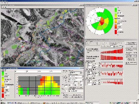
This is the GeoWAX interface. The map at the
upper left shows all the avalanche paths and their probabilities
of avalanching under this weather scenario. The rose diagram at
the upper right shows the probability of avalanching for various
aspect/elevation combinations for the entire mountain.
Chris finished his thesis in 2004 and currently works as an avalanche
forecaster for the Bridger
Teton National Forest Avalanche Center. His recent summers
have been spent working on an infrasonic avalanche detection project.
Chris's papers and thesis:
McCollister, C., K. Birkeland, K. Hansen, R. Aspinall, R. Comey.
2003. Exploring multi-scale spatial patterns in historical avalanche
data, Jackson Hole Mountain Resort, Wyoming. Cold Reg. Sci.
Tech. 37(3), 299-313. [Abstract]
[Article]
McCollister, C.M. 2004. Geographic knowledge discovery techniques
for exploring historical weather and avalanche data. M.S. Thesis,
Department of Earth Sciences, Montana State University. 106 pp.
[PDF (2.8 MB)]
McCollister, C., K. Birkeland, K. Hansen, R. Aspinall, R. Comey.
2002. A probabilistic technique for exploring multi-scale spatial
patterns in historical avalanche data by combining GIS and meteorological
nearest neighbors with an example from the Jackson Hole Ski Area,
Wyoming. Proceedings of the 2002 International Snow Science
Workshop, Penticton, BC, Canada, 109-116. [Article (2 MB)]