|
|||||||||||||||||||||

|
|
|||||
|
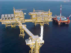
Mexico MMS Cooperation with Mexico History: On June 9, 2000, Secretary of State Albright and Secretary of Foreign Relations Rosario Green of Mexico signed the U.S.-Mexico Maritime Boundary Treaty establishing a continental shelf boundary separating United States and Mexican jurisdiction in an area of the Gulf of Mexico known as the "western gap.” Recent Developments: The U.S. has a long standing relationship with Mexico through the International Committee on Regulatory Research and Development (ICRARD) with whom both the MMS and the Mexican Institute of Petroleum (IMP) are members. The ICRARD focuses on transferring knowledge in the area of health, safety and environment in the petroleum sector. The ICRARD's purpose is to coordinate research activities, to exchange information, and to promote research cooperation between these organizations. The ICRARD seeks to establish ‘Terms of Reference’ to: provide a forum to advise on research and development activities funded by offshore regulatory authorities; exchange details of current research and development programs on a regular basis; make available reports from completed research and development programs to other authorities; co-sponsor research and development projects, when appropriate; and exchange information on research and development program strategy. Most recently, under ICRARD recently participated in a discussion regarding hurricane Katrina research with the Mexican Institute of Petroleum (IMP) and the Society of Earthquake Engineering (SMIS) during the 9th Symposium on Strategic Construction and Natural Hazards in Ixtapan de la Sal, Mexico from February 21st – 24th, 2007. Initially sought in 2002 but resurrected in the last couple years, the MMS and the Secretaria de Energia of Mexico have been seeking to sign an MOU that will enable the Parties to share scientific and technical information related to offshore oil, gas and mineral activities including but not limited to information on risk perception, safety of personnel and offshore installations, environmental protection, pollution prevention, pipelines, and Floating Production Storage and Offloading facilities, accident/incident reporting and the development and evaluation of regulations in accordance with this Memorandum of Understanding (hereinafter referred to as "MOU") which establishes the procedure for cooperation. The purpose of this MOU is to establish a framework for the exchange of scientific and technical knowledge with respect to offshore oil, gas and mineral activities. Cooperative activities in may include exchanges of technical information, cooperative research, and exchange visits of individuals sponsored by either Party within the scope of programs of the Participants. Internal discussions with MMS are currently taking place to determine whether both Parties want to pursue a binding or non-binding MOU. Privacy | Disclaimers | Accessibility | Topic Index | FOIA Last Updated: 11/19/2008, 05:22 PM
|
||||||