|
Congress authorized a Library for the U.S. Geological Survey (USGS) in 1879. The library was formally established
in 1882, with the naming of the first librarian, and began with a staff of 3 and a collection of 1,400 books. Since no
specific classification scheme existed for such a specialized library, one was developed in 1904 for use in an Earth
science library (see U.S. Geological Survey Bulletin 2010).
Exchange:
The Act of Congress establishing the USGS authorized the creation of a program for exchanging copies of USGS reports
for publications of state, national, and international organizations. The exchange program was modeled after a program
used by Dr. Ferdinand V. Hayden when he was head of the Interior Department’s U.S. Geological and Geographical
Survey of the Territories (1867-1879). The U.S. Geological Survey Library inherited 1,000 volumes of serials from
Dr. Hayden’s former exchange program, which he had based on the program begun by the Smithsonian Institution in
1846.
Gifts:
After Dr. Hayden died in 1887, his widow donated his personal collection to the U.S. Geological Survey Library. Other
early gifts were made by Major Powell, second Director of the Survey, who donated his collection of State Geological
Survey reports and the family of Dr. Isaac Lea (Philadelphia publisher and gem collector whose family donated nearly
600 items of his personal library). Dr. William Halliday, a world renowned speleologist began donating his cave
collection in 2003.
Purchasing Personal Libraries:
In 1882, the Library purchased 1,894 volumes from Mr. Robert Clark, of Cincinnati, Ohio, who had been acquiring geologic
materials for forty years. At an auction in Paris, France, pieces of M. Jules Pierre Fracois Stanislas Desnoyer’s
library (Secretary of the Societe Geologique) was purchased in 1885 to start the foreign country collection. In 1895, a
selection was purchased from M. Gustave Cotteau’s library (a French geologist). In 1933, the Library acquired the
George F. Kunz collection for $1.00 from the former USGS employee and Vice-President of Tiffany & Co.
Transferred:
The Depression of the 1930’s affected USGS funding, but the library benefited from projects of the Emergency
Relief Administration and the Civil Works Administration. In 1946, the Heringen Collection was transferred from the
U.S. Geological Survey’s Military Geology Unit to the Library. In 1950, the Denver Library received photographs
from the Map Reproduction Branch and in 1954, field records from the Geologic Division. In January 1996, the USGS
Libraries in Reston and Denver received materials from some of the collections of the former Bureau of Mines libraries.
The libraries in Reston and Menlo Park have been designated as official Federal Government Depositories providing public
access to selected U.S. Government publications. In 2003, the Historic Topographic Map Archive and the NMD (National
Mapping Division) Research Collection were transferred to the Reston Library. In 2006, the U.S. Antarctic Resource Center
(USARC) was added.
Collection Size Today:
The original collection was based on exchange partnerships with domestic and international scientific organizations.
Today the library holds over 1.7 million books and journals, 700,000 maps, 370,000 microforms, 270,000 pamphlets,
260,000 black-and-white photographs, 60,000 color transparencies, 15,000 field record notebooks, and 250 videocassettes.
Materials include USGS publications as well as those produced by state and foreign geological surveys, scientific
societies, museums, academic institutions, and government scientific agencies. The libraries in Reston and Menlo Park
are designated as official depositories for selected U.S. Government publications.
In 1948, technical branches and field offices were first authorized to create reference collections and the first
branch of the Survey Library was established at the Denver Federal Center. A librarian was assigned to the Survey’s
Western Office in San Francisco (1951) to purchase items for Menlo Park, the second branch library, which opened in
1956. The Flagstaff Library opened in 1964 to support the astrogeological work of the USGS and NASA’s Project Apollo.
The Washington Library was moved and became the Reston Library when the USGS headquarters moved to Virginia in 1974.
In celebration of the USGS 125th anniversary, the Reston Library was named the "Clarence King Library"
after the agency’s first Director. In addition to the four libraries of the Geospatial Information Office’s
Natural Science Network (Reston, Denver, Menlo Park, Flagstaff), the USGS has smaller libraries for science centers and
field offices across the country with items related to the research group at each location.
The establishment of branches of the Survey Library in Denver and Menlo Park created the necessity to develop a
collection of materials available locally so loans would not always be needed from the (former) Washington, D.C. Library.
Branch libraries reduced cost and delays of shipping, deterioration of the materials, and problems with most-wanted
materials being available. In 1956-57, the cards of the main card catalog were copied photographically for the branch
and field libraries. Additionally, G. K. Hall & Co published the entire library card catalog in book form with
periodic updates of new acquisitions for access at public, academic, and special libraries.
The Bibliography of North American Geology was a series that was provided by the library for reference. In 1960, the
job was transferred to the Office of the Staff Geologist for Publication and was published until in 1973 when this
activity was taken on by the American Geologic Institute. This information can now be accessed through GeoRef, a
bibliographic database covering worldwide literature on the geosciences.
In 1975, the Library began using a computerized system to share resources (OCLC) with other libraries. The last
card was filed in the card catalog in 1986. New materials have been added to the online library catalog and the items
from the card catalog are retrospectively added. Internet access to the library catalog became available in 1999. The
New Acquisitions List was first posted online in 2002 as a way to view titles added to the USGS Library system. Through
the interlibrary loan program, libraries in every state and 37 countries of the world have borrowed items from the
USGS Library’s unique collections.
The U.S. Geological Survey Library system has become the largest earth science library in the world. Materials within
the library system include books and maps dating back to the 16th and 17th centuries. Other materials include a nearly
complete set of the various State Geological Survey publications and a virtually complete set of USGS topographic maps.
Today library users have access to over 3 million items: books, periodicals and journals, maps (thematic, topographic,
raised relief), microfiche, microfilm, pamphlets, photographs (aerial as well as landscape, in color and black and white),
transparencies, field record notebooks, 16 mm film, album slides, lantern slides and negatives, videos and audio tapes,
computer media, globes, foreign language materials and electronic books.
Foreign Materials — Planners have used the foreign map collections to study foreign terrain, geologic
conditions and natural resources. During WWII, The New York Times (June 11, 1944) reported "A ‘Commando’
raid by a group of civilian scientists, a search through obscure seventeenth century French manuscripts, months of
study of geological reports, experiments with model beaches – all these were part of the Allied preparations for
the invasion of Normandy … The dramatic story of the preparations, which began in … libraries, shifted to
laboratories and ended on the shell-swept beaches …". The collections were consulted for the military
interventions in Afghanistan and Iraq. Library maps have provided aid in international disaster areas such as the
aftermath of Hurricane Mitch and volcanoes world-wide. A brief mention of a diamond found in the 1906 annual report of
the USGS began a trail of research and investigation that led one geologist to prospect for diamonds in Canada.
National thematic maps and topographic maps — The library’s map collections have provided
invaluable aid to authorities and scientists in times of crisis (the California Northridge earthquake in 1994 and
major fires in the nation’s forests). Topographic maps have also been used for genealogy research to pinpoint
where ancestors lived, locate forgotten cemeteries, provide information on boundary changes, and research natural and
man-made changes to areas over time.
Literature, photographs, and maps — The USGS Library has provided evidence to solve boundary disputes,
water rights litigation and to trace geographic names.
Special Collections — The Kunz Collection provided Smithsonian researchers with information about the
Hope Diamond’s possible connection to the missing "French Blue Diamond."
| 1879 – |
Congress provided for a U.S. Geological Survey Library modest collection in USGS headquarters (1879-1881)
at 803 G Street, NW opposite the Patent Office building – then home of DOI. |
| 1881 – |
Georgina Marvine appointed temporary Librarian. |
| 1882 – |
Charles C. Darwin became the first Librarian (located in National Museum Building, now the
Smithsonian’s Arts and Industries Building) |
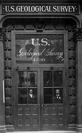
| 1885 – |
Library moved to the Hooe Building (1330 F Street NW, Washington, D.C.) |
| 1892 – |
Congress requires public access to the USGS and other Federal libraries. |
| 1904 – |
Library classification scheme devised (see USGS Bulletin 2010) |
| 1905 – |
Fire in the Library caused damage to some books and steel shelves were installed |
| 1910 – |
Fire in the Library damaged the collection |
| 1913 – |
A major fire in the Library destroyed 60,000 books and 175,000 copies of the latest topographic maps |
| 1915 – |
Cataloging of the collection completed |
| 1917 – |
USGS moved to the new Interior Building (GSA building 19th and F Streets NW in Room 1033) — the first
known instance of a wing in a government building built to hold a library’s collection |
| 1933 – |
George F. Kunz Collection acquired |
| 1933-1934 – |
Depression affects Library funding but Civil Works Administration provided 50 workers |
| 1934 – |
Federal Emergency Relief Administration provided 100 workers and a Bindery Unit was started |
| 1940 – |
Reference service introduced |
| 1942 – |
Five people with bibliographic training assigned to Military Geology Unit |
| 1946 – |
Denver Library established |
| 1946 – |
Heringen Collection transferred from the Military Geology Section |
| 1947 – |
Library transferred from Office of Chief Clerk to Geologic Division |
| 1949 – |
Denver Library became part of the USGS Library System |
| 1950 – |
U.S. Geological Survey’s photographic collection transferred to the Library in Washington, D.C. |
| 1951 – |
Western Region Library started in San Francisco, CA |
| 1954 – |
Photographic and field-records collections moved to the Denver Library |
| 1956 – |
Western Region Library moved to Menlo Park, CA |
| 1956 – |
Card catalog photocopied and exchanged so users could search entire collection at the field centers |
| 1960 – |
Geological Survey Library became part of the Office of Scientific Publications |
| 1964 – |
Flagstaff Library opened in the Center of Astrogeology Building (Building One) |
| 1964 – |
GK Hall publishes the USGS Library Book Catalog of 25 volumes, with subsequent multi-volume suplements |
| 1974 – |
Library moved from Washington, D.C. and Silver Spring, Maryland to Reston, VA |
| 1975 – |
Library first started to use OCLC |
| 1976 – |
Traditional public card catalog closed |
| 1976 – |
Major fire in a laboratory above the Denver Library caused water damage to materials |
| 1977 – |
Use of the M( ) call number classification on maps began |
| 1980 – |
Library collection from the National Center basement moved to a warehouse in Herndon, VA, after floods |
| 1983 – |
First integrated library system (ILS) acquired -- Online catalog |
| 1986 – |
Last card filed in shelf list |
| 1988 – |
Denver Library relocated to the Federal Center |
| 1990 – |
Book collection at Herndon, VA, warehouse was moved to the National Center |
| 1991 – |
Map collection at Herndon, VA, warehouse was transferred to the National Center |
| 1991 – |
Warehouse map collection consolidated with part of Reston’s collection to form the Cartographic
Information Center in the National Center |
| 1992 – |
Library classification scheme published as USGS Bulletin 2010 |
| 1995 – |
Arrival of Horizon: Second generation online system |
| 1996 – |
National Biological Survey (Fish and Wildlife Service – NBS) transfered to the USGS and became the
Biological Resource Division (BRD). Many BRD Science Centers have
research libraries |
| 1996 – |
First generation online system (LS2K) out of service |
| 1996 – |
Reston and Denver received Minerals Information Collections from the Bureau of Mines Libraries |
| 1998 – |
Reston Library moved from 4th floor to 1st floor in the National Center |
| 1999 – |
Library catalog became available on the internet |
| 1999 – |
Patrons required to use library cards |
| 2000 – |
Flagstaff’s Building One suffered damage after snow storm |
| 2000 – |
The USGS Library Consortium formed |
| 2000 – |
Library became NACO (Name Authority Cooperative Program) participant |
| 2000 – |
Library added to 1-888-ASK-USGS telephone information tree |
| 2001 – |
Flagstaff Library temporarily relocated due to damage from storm in 2000 |
| 2002 – |
Flagstaff Library moved into new building Shoemaker Center for Astrogeology (Building 6) |
| 2002 – |
Monthly list of new titles (New Acquisitions Lists) became available online |
| 2002 – |
Reston’s Geoscience Education Outreach Center closed (GeoCenter) |
| 2003 – |
Library allows patrons to look at their circulation records and renew items on their own |
| 2003 – |
USGS Libraries transferred to Geographic Information Office (GIO) |
| 2003 – |
NMD Reference Collection and Historic Topographic Map Archive transferred to Reston Library |
| 2004 – |
As part of the USGS 125th anniversary celebration, Reston Library was named in honor of the first
Director, Clarence King |
| 2005 – |
USGS Libraries became part of newly formed Natural Science Network |
| 2005 – |
First library material "overdue notices" sent by e-mail |
| 2005 – |
USGS Libraries and the Earth Science Information Centers merged to become the Science Information and
Library Services Center (SILSC) |
| 2006 – |
U.S. Antarctic Resource Center (USARC) transferred to the Reston Library |
| 1882-1902 |
Charles C. Darwin, first Chief Librarian |
| 1903-1908 |
Fred B. Weeks, second Chief Librarian |
| 1908-1929 |
Julia L. V. McCord, third Chief Librarian |
| 1929-1940 |
Guy E. Mitchell, fourth Chief Librarian |
| 1940-1969 |
William H. Heers, fifth Chief Librarian |
| 1969-1985 |
George H. Goodwin, Jr., sixth Chief Librarian |
| 1985-1988 |
Elizabeth J. Yeates, seventh Chief Librarian |
| 1988-1993 |
Barbara A. Chappell, eighth Chief Librarian |
| 1995-1999 |
Edward H. Liszewski, ninth Chief Librarian |
| 2000-2005 |
Nancy L. Blair, last Chief Librarian |
Blair, Nancy, and R. Lee Hadden. "The USGS Library: a National Resource." People, Land & Water Mar. 2004:
p. 18.
Blair, Nancy L., and R. Lee Hadden. "The USGS Library –– a National Resource." USGS 125th Anniversary.
28 Oct. 2004. U.S. Geological Survey. 21 June 2006 http://www.usgs.gov/125/articles/library.html.
Hadden., R. Lee. George F. Kunz Collection, U.S. Geological Survey Library, Reston, VA. Geoscience Information Society.
Denver, CO: Geoscience Information Society, 1999. p. 123-146.
Hadden, R. Lee. "The Heringen Collection of the USGS Library." People, Land & Water Aug. 2004: p. 37.
Irwing, W.C. Office of the Chief Geologist. U.S. Geological Survey. Report on the Geological Survey Library : Its History,
Technical Work, Resources, Management. Washington, D.C.: U.S. Geological Survey, 1962.
Liszewski, Edward. "History of the U.S. Geological Survey Library: Our Position Within the Survey / Branch / Region;
Budget, Administration, Etc." Learn About Our Library (Series of Management Presentations). National Center, Reston,
Virginia. 13 and 14 Jan. 1994.
"Media Advisory: USGS Library to Hold Grand Re-Opening." USGS News Releases. 22 Apr. 1999. U.S. Department of
the Interior, U.S. Geological Survey, Office of Communication. 21 June 2006
http://www.usgs.gov/newsroom/article.asp?ID=1335.
"USGS Release: Not Just Another Library –– At the USGS in Menlo Park (3/21/2001)." USGS News
Releases. 21 Mar. 2001. U.S. Department of the Interior, U.S. Geological Survey. 21 June 2006
http://www.usgs.gov/newsroom/article.asp?ID=500.
U. S. Geological Survey. Reston: U.S. Geological Survey, 1968.
U. S. Geological Survey Library. Reston: U.S. Department of the Interior, U.S. Geological Survey, 1970.
U. S. Geological Survey Library. FS-125-03 ed. Reston: U.S. Geological Survey, 2003.
Willis, Dawn E. "The History and Present Status of the Library of the United States Geological Survey."
Thesis. Catholic Univ. of America, 1953.
|