|
|
|
Welcome to the NRCS
Soils Website.
Helping People Understand Soils
Soils is part of the National Cooperative
Soil Survey, an effort of Federal and State agencies,
universities, and professional societies to deliver
science-based soil information.
 |
Web Soil Survey 2.1 was recently launched by
NRCS.
This web-based program provides a wealth of
soils information including soil maps,
properties, and interpretations aimed at helping
visitors with land use decisions. Some of the
enhancements to version 2.1 include a search
feature, the capability to download raw soil
data clipped to the area of interest,
multi-sheet printable maps, a distance measuring
tool, and performance improvements. |
...More Info
|
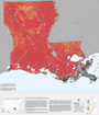 |
Soil interpretation maps for emergency response
and disaster recovery are being updated for
2008. New maps for Florida and Lousiana,
including interpretations for sources of sand,
gravel, and roadfill; suitability for
catastrophic large animal disposal; and other
interpretations have just been posted to the
Soil Geography section. |
...More
Info
|
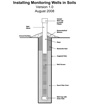 |
This document provides general guidance on how
to install and use piezometers and water-table
wells to investigate soil water regimes under
conditions commonly encountered in Soil Survey
and hydropedology studies. |
...More
Info
|
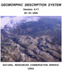 |
The Geomorphic Description System (GDS) is now
available in PDF format. This document
provides a descriptive method and a technical
guide for applying and understanding geomorphic
and geologic concepts and terms for soil
inventory in the National Cooperative Soil
Survey (NCSS) Program. Definitions, criteria,
concepts, and operational guidelines presented
focus on soil inventory needs and applications. |
...More
Info
|
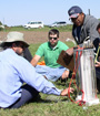 |
A website has been developed to assist National
Cooperative Soil Survey (NCSS) soil scientists and
their supervisors in identifying training
opportunities and resources. Links are provided
for schedules, course descriptions, job aids to
supplement training, and other helpful topics.
GIS-related training includes: (1) GIS
fundamentals for all soil scientists; (2) a
recommended sequence of GIS-related training,
especially for newly hired soil scientists; and
(3) training for employees of all soil
survey-related offices.
|
...More
Info
|
The Natural Resources Conservation Service
provides leadership in a partnership effort to help people
conserve, maintain, and improve our natural resources and
environment.
Last Modified: 01/14/2009
|
|
|