Photo Album - The Foundation
- Air Mail Pioneers
- MacCracken and the Aeronautics Branch
- Safety Certification Begins
- Building the Airways
- Airway Communications
- Aeronautics Branch Aircraft
- Vidal and the Bureau of Air Commerce
Building the Airways
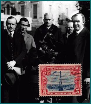
Enthusiasm for the new aerial highways was reflected in the 5 cent air mail stamp of 1928. One of the light beacons used to mark the airways is shown on the stamp and in the photo below. |
|
The tower usually stood in the center of a concrete arrow 70 feet long. A generator shed, where required, stood at the "feather" end of the arrow. |
 |
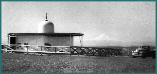
| Another feature of the early airways were intermediate landing fields. Federal authorities established these facilities where needed to ensure that pilots could land safely at intervals of approximately 50 miles along their route. The fields were usually colocated with light beacons, as shown in this scene from the late 1920s or early '30s. The conical object at left is a boundary marker light. (National Archives photo) |
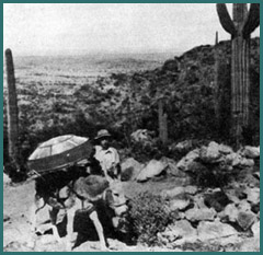 Those who constructed the airways often faced adverse weather and terrain. In remote areas of the Southwest, burros played an important role in transporting equipment and materials. When slopes proved too rugged for even these sure-footed animals, the Airways Division built "trolley lines" to haul material along cables mounted on poles.
|
 To limit expenses, Secretary of Commerce Hoover assigned many of the new aviation responsibilities to existing organizations within his Department. The Airways Division, for example, was structurally part of the Bureau of Lighthouses. This arrangement continued until July 1933, when the Aeronautics Branch assumed sole responsibility for the airways.
In this 1931 photo, the "Lighthouse" designation appears above the door of the airway station at Elko, Nevada. |
 Keeping the airways in operating condition was always a demanding task, but not without its lighter moments. Technician "Dusty" Rhodes is shown relaxing beside his truck in this photo from the late 1930s. He is wearing the uniform of airway station keepers during that era.
|
 In the late 1920s, the Aeronautics Branch began establishing a new type of navigational aid, the low frequency radio range (LFR), also know as the four-course radio range. This type of facility could provide guidance even when poor visibility made light beacons useless.
By comparing two coded signals generated by an LFR, pilots could tell whether they were drifting to the left or right of an airway. For those flying on course, the two signals merged into a single tone. The range shown above, at Northway, Alaska, was the last LFR to continue in operation. (National Archives photo) |
 By the time the Northway range fell silent in 1974, a new type of navigation facility had long dominated the airways: the Very High Frequency Omnidirectional Radio Range (VOR). Based on technology developed during World War II, the VOR enabled the pilots of instrument-equipped planes to determine their position more efficiently. The Civil Aeronautics Administration commissioned the first VOR in 1947, and three years later opened the first "Victor" airways based on chains of the facilities. Modernized versions of these navigation aids still guide pilots to their destinations.
|