|
|
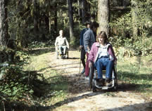
Featured Accessible SitesWe've selected the sites below to showcase some of our premier accessible sites. There are many more sites that offer some degree of accessibility. Please check individual trail and campground descriptions in our Trip Planning section for more opportunities. Accessibility
in rustic forest settings North Santiam Travel Corridor McKenzie Travel Corridor South Santiam Travel Corridor
Middle Fork Travel Corridor
What do we mean by "accessible" forest sites?Forest settings are rustic, most often without curbs, sidewalks or handrails. Some have paved surfaces, some do not. Some assistance may be required at some places. Though we strive to remove as many physical barriers as possible when we develop or modify sites, the woods are very different from urban settings. So we often refer to these sites as "barrier free" to distinguish them from more built up urban places. Our goal is to match the person with the place. The forest offers a range of recreation opportunities from developed campgrounds to primitive settings. The best way to talk about accessibility in the forest setting is to describe the features of the site: what is the grade of trails? is the surface compacted or loose gravel? are there accessible restrooms? People also look for different outdoor experiences. Some are looking for easy access to enjoy a view; others may be looking for a physical challenge. On this feature page, we've included sites that offer a range of settings and different degrees of development. The descriptions below should help guide you to a site that matches your interest and ability. Please let us know how this information meets your needs. North Santiam Travel CorridorHoover Campground
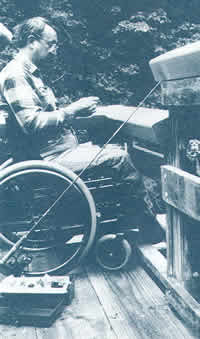
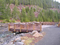
Upper Arm Day Use Area, located about 1.5 miles north of Detroit, offers families a full range of accessible amenities including trails, picnic site, wildlife viewing, an interpretive site, fishing and swimming. The trails are surfaced with compacted gravel and have safety rails on the steeper sections. The trails are 4 to 5 feet wide and range from 2 to 8 percent grade. The paved parking area provides easy access to restrooms and other facilities. This site does NOT have potable water. Upper Arm Day Use site description
McKenzie Travel CorridorDelta Campground and Nature Trail
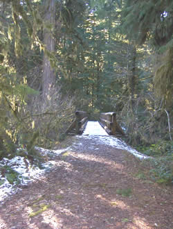
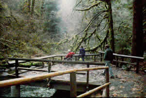
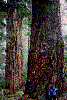
This recreation complex is located on gentle ground, featuring hardened access routes from campsites to toilets and an amphitheatre. It is located just a couple of miles east of Blue River, at the northernmost entry to the Aufderheide Drive (Forest Road 19). Six campsites and two toilet facilities are accessible to people with disabilities. The wide, hardened paths into the amphitheatre are also accessible. The one-half mile Delta Nature Trail takes visitors of all abilities into the Delta Old Growth Grove. Here you can experience majestic old growth Douglas firs and Western red cedars – some over 180 feet tall – from an accessible interpretive nature trail. The trail is located at the west end of Delta Campground, and is open all year. The trail crosses beautiful side channels and streams, which “braid” through the McKenzie River delta. A brochure is available at the trailhead.
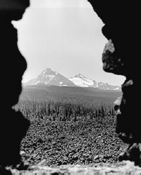
The Dee Wright Observatory is located just east of the summit of the McKenzie Pass (Route 242) at milepost 77.5. Plan to visit in summer since snow blocks the highway from about mid-November through late June. The Observatory was built from lava rock during the Great Depression by the Civil Conservation Corps Camp F-23 CCC Company 927, located at Camp Belknap. After the “lava house” was constructed, a 36” diameter bronze “peak finder” was installed on the top level – identifying the surrounding mountain peaks. The observatory is named for Dee Wright (1872-1934), a Forest Service packer for 24 years, and the foreman for the CCC. Today, people of all abilities can visit the observatory. A paved access trail leads visitors from barrier-free toilet facilities into an interpretive court where stories of early travelers and area geology are shared. The trail continues behind the observatory into the interior of the observatory structure. From this point, Visitors wishing to explore the brong peak finder take a staircase made of lava rock and mortar to the top of the structure. Future plans for this facilitiy include a barrier-free extension of the popular Lava River Trail.
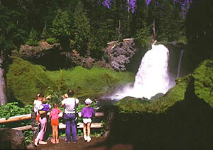
Visitors of all abilities will enjoy the stunning view of Sahalie Falls, where the McKenzie River plunges nearly 100 feet over a basalt cliff. The paved trail from the parking area takes visitors to a fully accessible toilet and an interpretive kiosk where stories of native Americans and area geology are told. Follow the trail across a short bridge to a paved platform for picture-perfect view of the falls and surrounding landscape. The Viewpoint is generally open most of the year, with the exception of December through February when the parking area is often blocked by snow. South Santiam Travel Corridor
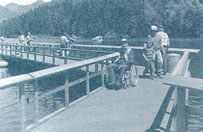
A 0.3 mile trail that is surfaced with compacted gravel and parallels the South Santiam River within Yukwah Campground (milepost 49 on Highway 20). This trail has a 36-inch tread width and grades of less than 5 percent. The trail offers access to six pulloffs and two accessible platforms for viewing the river. Yukwah Campground offers accessible campsites with compacted gravel surfaces, a day-use picnic site, and fully accessible restrooms. A number of sites are large enough to accommodate RVs. Two other river platforms are located within two miles of Yukwah campground and have asphalt parking lots and compacted gravel trails and for access. Walton Ranch Viewing Trail and Platforms
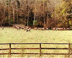
Walton Ranch Interpretive Trail is a 0.3 mile trail surfaced with compacted gravel. The trail uses a bridge across Trout Creek and two switchbacks up a moderately steep slope to bring visitors to a large platform with views down on the Walton Ranch and the South Santiam River. The trail has a 36-inch tread with kick rails and only two short sections with grades between 5 and 8 percent. Walton Ranch, a historic homestead along on the old Santiam Wagon Road, is managed as meadow habitat for local elk herds. Interpretive signs on the viewing
platform share information about elk management and prehistoric
use in the South Santiam watershed. The trailhead is located
at mp 48 on Highway 20 and across the highway from Trout Creek
campground.
Trout Creek campground offers a couple of campsites with graveled
surfaces, a day-use picnic shelter, and accessible toilets.
Hackleman Old-Growth Grove Trail A challenging 1.0-mile loop trail that is surfaced with compacted gravel and meanders through a mixed-conifer old-growth grove. The trail has a 36-inch tread, and extended sections with grades between 5 and 8 percent. Numbered posts located along the loop trail link to an interpretive brochure (available at the trailhead) for understanding features of a transitioning old-growth forest. The trail winds up at a viewpoint next to Hackleman Creek at the half-way mark before climbing back up to the trailhead along a section of the old Santiam Wagon Road. Hackleman Creek is home
to a distinct subspecies of cutthroat trout that has become
isolated from McKenzie River populations by lava flows within the
last
10,000
years. The trailhead is located at mp 69 on Highway 20 and
approximately 1.5 miles west of Lost
Prairie Campground. Lost Prairie
campground
offers accessible campsites and restrooms. This trail is surfaced with compacted gravel and travels less than 1000 feet to two primitive campsites to Daly Lake. The trail has a 36-inch tread with kick rails, and extended sections between 5 and 8 percent. The parking lot has a compacted gravel surface, trash cans, and an accessible toilet. The two campsites have compacted gravel surfaces, a fire ring, a picnic table, and room for tent camping. This site does not have potable water. An accessible bridge has been placed over the inlet stream to Daly Lake and a graveled trail will be extended to the future site of a fishing platform on the lake’s edge. A non-surfaced trail continues around Daly Lake. Daly Lake is 8 acres and offers a healthy population of Brook
Trout and a peaceful camping location that was a favorite springtime
stop for Judge John Emerson Waldo during his mountain travels to
the high Cascades. The Daly Lake trailhead is located on road 2266-450
which is a little more than 5.2 miles off Highway 22 (mp 25.7). Middle Fork Travel Corridor
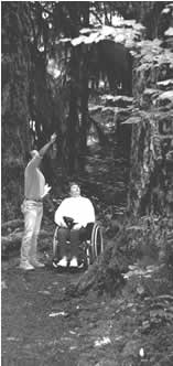
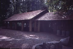
This Organization Camp is located adjacent to Clark Creek on the north bank of Fall Creek in an overstory of Douglas-fir, western hemlock and western red cedar. This camp was one of four of this type of camps constructed in 1936-1937 by the Civilian Conservation Corps. Clark Creek is popular and has seen continuous use by groups for over 50 years. Reliable, repeat visitors have made Clark Creek their traditional retreat for reunions, weddings and other group outings. Some improvements were made to the site in the 90's to provide universal access.
Many groups with limited mobility have stayed at Clark Creek.
The site includes a double vault accessible toilet, the paths
throughout
the camp are paved with asphalt and the parking area has been surfaced.
Groups take pleasure in the use of the community kitchen and large
dining area, a stone fire ring, five camp shelters, an amphitheater/chapel,
and a softball field. Salt Creek Falls Observation Site and Picnic Area
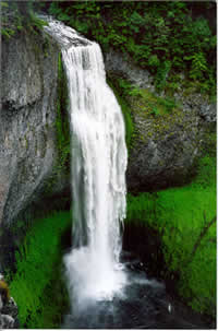
Salt Creek Falls is the second tallest falls in Oregon, dropping 286 feet. Salt Creek Falls is an impressive site, located just off Highway 58, at an elevation of 5,000 feet, five miles west of Willamette Pass. These beautiful, cascading falls can be viewed year round but accessibility is limited in the winter because of snow pack. Accessible facilities include parking, restrooms and a well maintained trail. A loop trail starts at the paved parking lot near the kiosk. Interpretive signs about the area and the formation of the falls are displayed at the kiosk. About 50 yards down the trail is the viewing platform, which has rails specially designed for viewing the falls from a wheelchair. This is an ideal location for taking wonderful scenic photos. The trail to the right of the platform is not accessible due to stairs. To the left of the viewing platform the barrier-free trail continues to follow the creek and loop past the picnic area, returning to the parking lot. Waldo Lake Area: Islet Campground
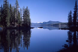
Ancient glaciers formed Waldo Lake which lies high on the western slope of the Cascades. Its crystal clear and exceptionally blue water cover more than 10 square miles and reaches a depth of 420 feet. Three campgrounds are located on the east shore of Waldo Lake. Islet Campground lies on gentle terrain making it fairly easy to provide access for visitors of all abilities. Twelve sites in Islet have barrier-free fire rings, picnic tables, curbed tent pads, trash receptacles and water hydrants. The key trails throughout the campground, including beach routes have been surfaced and safety barriers installed
|
||||||||||||||||||||
|

|