empty Federal Aviation Administration Seal
empty FAA Home About FAA Jobs News Library empty
empty Pilots Travelers Mechanics More empty
empty
empty
empty
empty
Aircraft
empty
Airports &
Air Traffic
empty
Data &
Statistics
empty
Education &
Research
empty
Licenses &
Certificates
empty
Regulations &
Policies
empty
Safety
empty
Search:  

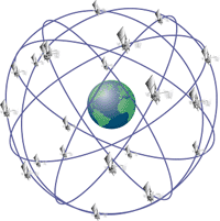
GPS Basics

The Global Positioning System (GPS) is a space-based radio-navigation system consisting of a constellation of satellites and a network of ground stations used for monitoring and control. A minimum of 24 GPS satellites orbit the Earth at an altitude of approximately 11,000 miles providing users with accurate information on position, velocity, and time anywhere in the world and in all weather conditions.

GPS is operated and maintained by the Department of Defense (DoD). The National Space-Based Positioning, Navigation, and Timing (PNT) Executive Committee manages GPS, while the U.S. Coast Guard acts as the civil interface to the public for GPS matters. The Federal Aviation Administration is investigating and applying the use of GPS as it pertains to aviation.

Earth with 24 satellites

History and Development

The Global Positioning System, formally known as the Navstar Global Positioning System, was initiated in 1973 to reduce the proliferation of navigation aids. By creating a system that overcame the limitations of many existing navigation systems, GPS became attractive to a broad spectrum of users worldwide. The Global Positioning System has been successful in virtually all navigation applications, and because its capabilities are accessible using small, inexpensive equipment, GPS is being utilized in a wide variety of applications across the globe.

Updated: 4:41 pm ET June 13, 2007