Navigation Services
GPS - How It Works Satellite Navigation is based on a global network of satellites that transmit radio signals in medium earth orbit. Users of Satellite Navigation are most familiar with the 24 Global Positioning System (GPS) satellites*. The United States, who developed and operates GPS, and Russia, who developed a similar system known as GLONASS, have offered free use of their respective systems to the international community. The International Civil Aviation Organization (ICAO), as well as other international user groups, have accepted GPS and GLONASS as the core for an international civil satellite navigation capability known as the Global Navigation Satellite System (GNSS).
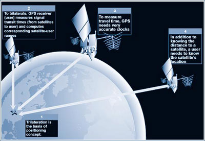
The basic GPS service provides users with approximately 100-meter accuracy, 95% of the time, anywhere on or near the surface of the earth. To accomplish this, each of the 24 satellites emits signals to receivers that determine their location by computing the difference between the time that a signal is sent and the time it is received. GPS satellites carry atomic clocks that provide extremely accurate time. The time information is placed in the codes broadcast by the satellite so that a receiver can continuously determine the time the signal was broadcast. The signal contains data that a receiver uses to compute the locations of the satellites and to make other adjustments needed for accurate positioning. The receiver uses the time difference between the time of signal reception and the broadcast time to compute the distance, or range, from the receiver to the satellite. The receiver must account for propagation delays, or decreases in the signal's speed caused by the ionosphere and the troposphere. With information about the ranges to three satellites and the location of the satellite when the signal was sent, the receiver can compute its own three-dimensional position. An atomic clock synchronized to GPS is required in order to compute ranges from these three signals. However, by taking a measurement from a fourth satellite, the receiver avoids the need for an atomic clock. Thus, the receiver uses four satellites to compute latitude, longitude, altitude, and time. GPS is comprised of three segments:
*Please refer to ftp://tycho.usno.navy.mil/pub/gps/gpstd.txt for an update on the total number of GPS satellites in orbit. Additional GPS Tutorials Available On-line
|