The Atchison Topeka and Santa Fe
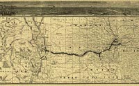
A Geographically
Correct County Map of the States Traversed by the Atchison
Topeka and Santa Fe Railroad and Its Connections.
St. Louis: Woodward, Tiernan, and Hale, 1880
Printed map
Geography & Map Division (133.15)
Digital ID: http://hdl.loc.gov/loc.gmd/g4051p.rr003210
|
During the last quarter of the nineteenth century, railroads spanned
the boundless immensity of the American west. Vast networks of
iron track bound
together the rapidly multiplying cities and provided access to fertile lands,
mineral wealth, and magnificent vistas. This detailed map of the central U.S.
shows drainage, counties, cities and towns, roads, wagon trails, and the railroad
network. The Atchinson Topeka and Santa Fe Railroad was chartered by the state
of Kansas in 1859; the first 75 miles of line were not completed until 1871.
|