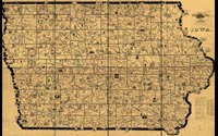
Galbraith's Railway Mail Service Map
Frank H. Galbraith
Galbraith's Railway Mail Service Maps, Kansas
Lithograph mapChicago, 1897
Geography & Map Division (14A.7)
Digital ID# g4151p rr002200
|
This one of eight large-scaled pictorial maps of midwestern states
showing routes and post offices of the Railway Mail Service. Designed
by Chicago railway mail clerk Frank H. Galbraith to help employees
of the Railway Mail Service quickly locate counties and post offices.
The mail service numbered more than 6,000 employees, who traveled
more than a million miles a year on the rails sorting mail. A printed
title cartouche accompanied by a list of counties for each of the
states by McEwen Map Company of Chicago is pasted on the maps.
|