|
Hispanic Division: Back to 20th-Century Arrivals from Portugal Settle in Newark, NJ
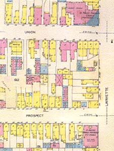
Fire Insurance Map Showing Two Portuguese Churches in Newark, NJEvidence of the Portuguese community in Newark can be found on fire insurance maps published during the first half of the twentieth century. On this particular sheet, which covers a five-block area in the Ironbound section of the city, there are two Portuguese churches -- St. Joseph's Spanish-Portuguese Roman Catholic Church and St. Paul's Presbyterian (Portuguese) Church, both located on Lafayette Street. One block to the east (shown on adjoining map sheets) is Ferry Street, the commercial center of this community.Fire insurance maps were published by commercial mapping firms to assist insurance underwriters in determining the risk involved in insuring individual properties. Consequently, these maps provide a block-by-block inventory of the buildings in most American cities and towns from the 1880s to the 1950s. Buildings are color coded to indicate construction material (pink for brick, yellow for wood, and blue for stone). Businesses and public institutions (schools, churches) are identified by name while individual residences are marked with the abbreviation "D" or "Dwg" for dwelling. The particular sheet shown here is taken from a 1930 edition, which has been updated to 1951 with paste-up corrections. The coverage for all of Newark for this date consists of 750 map sheets in eight volumes.
101 Independence Ave. SE Washington, D.C. 20540 |
SELECT FROM THE FOLLOWING: Fire Insurance Map Showing Two Portuguese Churches in Newark, New Jersey Page from Newark, New Jersey, City Directory Listing Portuguese Residents Portuguese-American Newspaper Published in Newark, New Jersey
|
