|
Who explored America? The
Discovery and Exploration collection documents European
exploration of the Americas. The earliest maps (15th to
17th centuries) focus on the mapping of the continents,
coastal areas and major waterways. Later maps (18th and
19th centuries) document the exploration of the interior
of the continents.
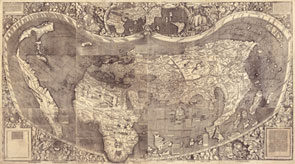
Featured Map: Using Martin Waldseemüller's 1507 world map, let's explore how a map of this type
might be used in the classroom. This map represented a huge leap forward in knowledge. It was the first map to clearly depict a Western Hemisphere, labeled America, separate from Asia, as well as showing the Pacific as a separate ocean. The map forever changed the European understanding of the world, which was previously divided into three parts: Europe, Asia and Africa. Click on the map to zoom in, and click on its caption for bibliographic information. What does this map show about how its makers saw the world? How do you think the discovery of a new continent or new ocean was received by scholars and the public? Explore the map for images and illustrations. What do they mean? Who are the two men at the top of the map?
View the special
presentation or the Webcast to learn more about this map.
Learning More: How did cartographers’
concepts of America change over time? Follow the links on
the right for a sampling of more exploration maps. View
the Discovery
and Exploration Cartographic Items to see all titles.
Go to the Waldseemüller's Map: World 1507 or the Drake's West Indian Voyage
lesson plans for more classroom activities. Students can
use the graphic organizer to
analyze these maps.
|