| |
|
|
What do we think of as "home"?
Perspective or "bird's-eye" maps of cities and
towns were popular during the late 19th and early
20th
centuries. In addition to providing geographical data, they
give the viewer a sense of terrain, landscape features,
street
patterns, individual buildings and transportation systems.
The Panoramic
Maps, 1847-1929 collection features digitized versions
of some of the more than 1,500 panoramic maps in the
Library of Congress
collection. Studying these maps can help one understand the
evolution and development of cities as well as learn about
the place we call "hometown."
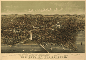
Featured Map: Using this 1892 City
of Washington map, let's explore how a map of this type
might be used in the classroom. Click on the caption below
the map for bibliographic information. Click on the map itself
to access the zoom view. What Washington landmarks existed
in 1892? Do they exist today? What modes of land transportation
can be observed? Do they differ from those used today? What
kinds of activities are taking place on the Potomac? Is there
evidence of industrialization in the area? What is the area
on the outskirts of the city like? In what ways has Washington
changed since this map was made?
Your Hometown: Use the links on the left
to locate panoramic maps, photographs and primary source material
from YOUR city or state. View the special presentation, Panoramic
Mapping, and the Panoramic Maps Collection
Connection for more information and additional teaching
ideas. Students can use the graphic
organizer to analyze maps of their hometown.
|
| |