Link to USGS home page
USGS Home
Contact USGS
Search USGS
Coastal & Marine Geology InfoBank

USGS CMG J-1-94-MB Metadata

Skip navigational links
Search InfoBank
Home tab FACS tab Activities tab Atlas tab Geology School tab More tab More tab Activities tabs
   
Activities: by ID   by Platform   by Year   by Region   by Participant   by Organization   by Project/Theme   with Incomplete IDs   Disclaimer  
Activity First Letter: A   B   C   D   E   F   G   H   I   J   K   L   M   N   O   P   Q   R   S   T   U   V   W   X   Y   Z   0   1   2   3   4   5   6   7   8   9  
Virtual Globes: Atlas  (GE)    Samples  (GE)    Illuminate Oceans  (GE)    Earthquakes  (GE)    Get GE    InfoBank examples    State Waters
J-1-94-MB links...
Metadata & Data: Imagery   Metadata   Navigation   imag (GE GM)   nav (GE GM)   times (GE GM)  
Formal Metadata: Frequently-Anticipated Questions   Outline   Parseable Text   XML  
   
   
Metadata
ID J-1-94-MB
Abstract Chief Scientists: Roberto Anima, J.F. Trait. Geological data (Kleinsidescan, Geopulse, GPS, bathymetry) of field activity J-1-94-MB in Nearshore area of the North-central California Coast from 02/28/1994 to 03/11/1994
National Plan Resource, Environment
Chief Scientist Roberto Anima
J.F. Trait
Activity Type Geological
Platform David Johnston
Area of Operation
Nearshore area of the North-central California Coast
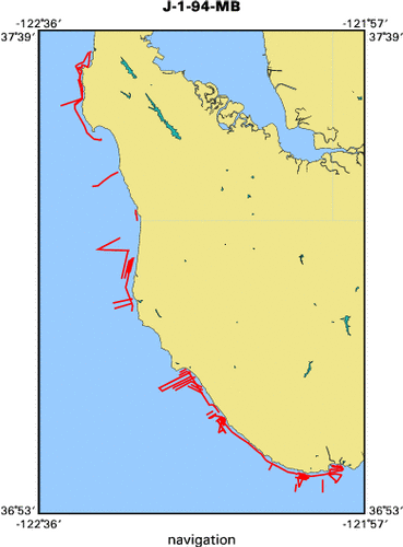
Location map J-1-94-MB location map of where navigation equipment operated
Bounding Coordinates 37.62242
-122.56220    -121.99521
36.91732
Dates 02/28/1994 (JD 059) to 03/11/1994 (JD 070)
Analog Materials list
Index map

J-1-94-MB map of where navigation equipment operated

Crew
Roberto Anima Chief Scientist, USGS Western Region
J. F. Trait Chief Scientist
Equipment Used
Kleinsidescan
Geopulse
GPS
bathymetry
Purpose
Three goals:
1. Image the coastal nearshore to determine areas of rock outcorps and
depositional sites for sand using side-scanning sonar;
2. Image the thickness of the sediment accumulation over bedrock using
high-resolution geophysical profiling;
3. Gather bathymetric profiling data to be used both for geophysical record
interpretation and for mapping of the nearshore areas previously
unmapped in detail by personnel of Pacific Marine Geology.
Summary
High-resolution Geophysical and side-scan sonar surveys along
the 40 meter contour between Pt. Santa Cruz to Rockaway Beach.
The cruise was a complete success. All sought after goals were met
with excellent results from all systems used.
Notes
Associated activities:

  M-1-93-MB

  J-1-94-MB

  J-2-95-MB
  J-6-95-MB
  M-2-95-MB
  P-1-95-MB
  P-3-95-MB
  R-1-95-MB

  M-1-96-MB

  J-1-97-MB
  J-3-97-MB

  A-4-98-MB
  J-3-98-MB
  J-4-98-MB

Most data is in the USGS data base. Only the geopulse data has not been
entered into the database and only because time has been scarce.
Got Help? For J-1-94-MB, we would appreciate any information on -- contract, days at sea, dive count, funding, information specialist, information to be derived, kms of navigation, NGDC Info, organization, owner, ports, project, project number, publications, scanned materials, seismic description, station count, station description, submersible, tabulated info.


Skip footer navigational links


InfoBank   Menlo Park & Santa Cruz Centers   St. Petersburg Center   Woods Hole Center   Coastal and Marine Geology Program   Geologic Information   Ask-A-Geologist   USGS Disclaimer  

FirstGov button   Take Pride in America button