|
|
|
Metadata
|
|
ID
|
F-3-91-CP
|
|
Also Known As
|
WESTPAC_GLORIA_LEG_2
|
|
Abstract
|
Chief Scientists: Stephanie Ross, Chris Gutmacher.
Geophysical data (Gloriasidescan, 10khz, GPS,
integratednavigation, RhoRho, gravity, magnetics,
2channelairgun, tempsalinometer, 3dot5khz,
expendablebatthermograph, airgunmonitor) of field activity
F-3-91-CP in Westpac, Central Pacific, Kingman, Palmyra
Sector #1 from 02/24/1991 to 03/25/1991
|
|
Project/Theme
|
Geological Long-Range Inclined Asdic (GLORIA)
|
|
National Plan
|
Resources
|
|
Chief Scientist
|
Stephanie Ross
Chris Gutmacher
|
|
Activity Type
|
Geophysical
|
|
Platform
|
Farnella
|
|
Area of Operation
|
Westpac, Central Pacific, Kingman, Palmyra Sector #1
|
|
Location map
|
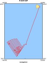
|
|
Bounding Coordinates
|
19.77030
-164.87230 -154.76311
4.41120
|
|
Ports
|
HILO, HAWAII
HONOLULU, HAWAII
|
|
Dates
|
02/24/1991 (JD 055) to 03/25/1991 (JD 084)
|
|
Analog Materials
|
list
|
|
Index map

|
|
|
Crew
|
|
John Nichols
|
Ship Captain
|
|
Alex Hay
|
Chief Mate
|
|
Mike Baldwin
|
Chief Engineer, USGS Western Region
|
|
John Wilson
|
Chief Scientist, IOS
|
|
Andy Webb
|
Mechanical Technician, IOS
|
|
Jon Campbell
|
Electrical Engineer, IOS
|
|
John Cherriman
|
Geologist, IOS
|
|
Robert Lloyd
|
Computer Analyst, Rvs
|
|
Chris Gutmacher
|
Chief Scientist, USGS Western Region
|
|
Stephanie Ross
|
Chief Scientist, USGS Western Region
|
|
Larry Kooker
|
Electronics Technician, USGS Western Region
|
|
Lisa Bader
|
Watchstander, USGS Western Region
|
|
Kaye Kinoshita
|
Watchstander, USGS Western Region
|
|
Libby Prueher
|
Watchstander, USGS Western Region
|
|
|
Equipment Used
|
|
Gloriasidescan
|
|
10khz
|
|
GPS
|
|
integratednavigation
|
|
RhoRho
|
|
gravity
|
|
magnetics
|
|
2channelairgun
|
|
tempsalinometer
|
|
3dot5khz
|
|
expendablebatthermograph
|
|
airgunmonitor
|
|
|
Purpose
|
|
|
Notes
|
|
|
NGDC Overview
|
|
! Converted to time format with year at start.
|
|
!
|
|
DATA COLLECTION OVERVIEW (use NGDC GEODAS CD to retrieve data)
|
|
|
|
MCG Data Collection ID --- F391CP
|
|
Institution Data Collection ID --- FARN0391
|
|
NGDC ID --- 06780064
|
|
Funding --- USGS
|
|
Project, Cruise & Leg --- MV FARNELLA CRUISE 3, 1991.
|
|
Study region --- +20.00000, +4.00000,-165.00000,-154.00000
|
|
Chief Scientist(s) --- DR J.B. WILSON, IOSDL
|
|
Name of vessel --- MV FARNELLA (surface ship)
|
|
Date field data collection started --- 02/25/91 HILO, USA
|
|
Date field data collection ended --- 03/21/91 HONOLULU, USA
|
|
Parameters surveyed ---
|
|
Bathymetry: surveyed, contained in data file
|
|
Magnetics: surveyed, contained in data file
|
|
Gravity: (unspecified)
|
|
High-resolution seismics: (unspecified)
|
|
Deep penetration seismics: (unspecified)
|
|
Format --- (I1,A8,F5.2,4I2,F5.3,F8.5,F9.5,I1,F6.4,F6.1,I2,i1,3F6.1,I1,F5.1,F6.0,F7.1,F6.1,F5.1,A8,4I1)
|
|
Date of data input to NGDC --- 04/25/94
|
|
Contributing institution --- NATURAL ENVIRONMENT RESEARCH COUNCIL
|
|
Country --- UNITED KINGDOM
|
|
|
|
Navigation instrumentation --- GPS
|
|
Position determination method --- SATELLITE
|
|
|
|
Bathymetry instrumentation --- IOS MK3 10KHZ ECHO-SOUNDER
|
|
Additional forms of bathymetric data --- ANALOG RECORDS
|
|
General rate of bathymetry in file --- 5.7 minutes
|
|
General collection rate of bathymetry --- (unspecified)
|
|
Assumed sound velocity --- (unspecified)
|
|
Bathymetric datum code --- No correction applied (sea level)
|
|
Bathmetry interpolation scheme --- (unspecified)
|
|
|
|
Magnetics instrumentation --- (unspecified)
|
|
Additional forms of magnetics data --- (unspecified)
|
|
General rate of magnetics in file --- 1.9 minutes
|
|
General collection rate of magnetics --- (unspecified)
|
|
Magnetic sensor tow distance --- (unspecified)
|
|
Magnetic sensor depth --- (unspecified)
|
|
Two sensor horizontal separation --- (unspecified)
|
|
Residual magnetics reference field --- (unspecified)
|
|
Method of applying residual field --- (unspecified)
|
|
|
|
Gravity instrumentation --- (unspecified)
|
|
Additional forms of gravity data --- (unspecified)
|
|
General rate of gravity in file --- (unspecified)
|
|
General collection rate of gravity --- (unspecified)
|
|
Theoretical gravity formula --- (unspecified)
|
|
Reference system --- (unspecified)
|
|
Corrections applied --- (unspecified)
|
|
Starting land tie --- (unspecified)
|
|
Ending land tie --- (unspecified)
|
|
|
|
Seismic instrumentation --- (unspecified)
|
|
Formats of seismic data --- (unspecified)
|
|
|
Publications
|
|
Gardner, J.V., Field, M.E., and Twichell, D.C., eds., 1996, Geology of the
|
|
United States' seafloor -- The view from GLORIA: Cambridge and New York,
|
|
Cambridge University Press, 364 p.
|
|
|
Got Help?
|
For F-3-91-CP, we would appreciate any information on -- contract, days at sea, dive count, funding, information specialist, information to be derived, kms of navigation, organization, owner, project number, scanned materials, seismic description, station count, station description, submersible, summary, tabulated info.
|
|


