| Projects & Studies
|
| »
|
Flood Risk Management Continuing Authority, Red River of the North: Wahpeton, N.D.
|
| »
|
Integrated Watershed Study: Minnesota River Basin in Minnesota, South Dakota, North Dakota and Iowa
|
| »
|
Lower St. Anthony Falls Rapids Restoration, Mississippi River, Minneapolis, Minn.
|
| »
|
Mississippi Headwaters Reservoirs Project Sites
|
| »
|
Mississippi Place, Mississippi River, St. Paul, Minn.
|
| »
|
Mississippi River Recreation and Environmental Stewardship, Eau Galle Dam
|
| »
|
Reconnaissance Study: Minnesota River Basin in MN, SD, IA and ND
|
| »
|
Recreational Boating Study of the Mississippi River, Pools 4 to 9, Summer 2003
|
| »
|
River Resource Values and Expectation
|
| »
|
Western Flood Control Sites - Minnesota: Lake Traverse, Orwell Lake, Hwy 75 - Bigstone, Lac qui Parle
|
| »
|
Western Flood Control Sites – North Dakota: Lake Ashtabula, Homme Lake Souris River
|
|
|
|
Mississippi Place, Mississippi River, St. Paul, Minn.
|
Location/Description
|
Section 577 of the Water Resources Development Act of 1999 authorized the U.S. Army Corps of Engineers to enter into a cooperative agreement with a non-federal sponsor for the planning, design and construction of infrastructure and other improvements at "Mississippi Place." Mississippi Place, also known as the Upper Landing Area, is located on the left bank of the Mississippi River in downtown St. Paul, Minn.
Once a project has been identified and a design agreement has been negotiated and signed, work will begin on an engineering documentation report. The report will advance the engineering and architectural design of the non-federal sponsor's preferred plan. The report will also include economic analysis and an environmental assessment. Corps' approval of the report will require that the project be economically justified and environmentally acceptable.
|
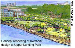
Between the authorization in 1999 and the first Federal appropriation of funds in 2003, Saint Paul Parks and
Recreation and their consultants, Close Landscape Architecture, advanced design concepts for the
riverfront area bounded by the relocated Shepard Road, Chestnut Street, and the riverbank. This portion of the
downtown riverfront is now known as Upper Landing Park. Analysis, programming, and conceptual design for the park culminated with the selection of a preferred concept design plan for the area.
The main purpose of the preferred design is to provide opportunities to experience the river’s edge on the downtown side of the Mississippi River. Prominent features of the design include a boat landing area; riverfront promenade; a gathering plaza; regional trail access; and river’s edge treatment with a retaining wall, ornamental railings, lighting, riprap, and riverbank plantings. The city began the first phase of this park construction in 2004 and completed this phase in 2006.
|
|
Status
|
The Corps of Engineers has worked with Saint Paul Parks and Recreation to identify a specific project that could lead to a cooperative agreement that will enable the Corps to participate in planning, design, and construction of infrastructure improvements at Mississippi Place. At this time, the parties have not been able to identify a potential project that would be economically beneficial for the city with respect to the Corps programs’ cost-share provisions.
|
|
Authority
|
Section 577 of the Water Resources Development Act of 1999 (Public Law 106-53).
|
|
Fiscal
|
Up to $3 million in federal funds has been authorized to carry out the project
$875,000 has been appropriated through fiscal year 2006.
|
|
|
[Printable Copy]
|