| Projects & Studies
|
| »
|
Benton County near St. Cloud, Minnesota
|
| »
|
Canisteo Mine Pit Flood Control Project, Itasca County, Minn.
|
| »
|
Chippewa River at Big Bend , Minnesota - Stream Bank Protection
|
| »
|
Crow River at Delano, Minnesota
|
| »
|
Devils Lake Basin, North Dakota
|
| »
|
Devils Lake Flood Risk Management Project
|
| »
|
Devils Lake Levee, North Dakota
|
| »
|
Devils Lake: Minnewaukan Flood Control Project, North Dakota
|
| »
|
Drayton Initial Assessment - Drayton, North Dakota
|
| »
|
Emergency Streambank Protection, Section 14, Brooklyn Center, Minn.
|
| »
|
Erosion along Highway 2, Red Lake River, Crookston, MN
|
| »
|
Fargo-Moorhead and Upstream Feasibility Study
|
| »
|
Flood Control: Downtown St. Paul Airport, St. Paul, Minnesota
|
| »
|
Flood Risk Management Continuing Authority, Red River of the North: Wahpeton, N.D.
|
| »
|
Flood Risk Management: Fargo-Moorhead Metro, North Dakota and Minnesota
|
| »
|
Flood Risk Management: Red Lake River, Crookston, Minnesota
|
| »
|
Flood Risk Management: Roseau River, Roseau, Minnesota
|
| »
|
Flood Risk Management: Twin Valley, Wild Rice River, Minnesota
|
| »
|
Hay Creek Aquatic Ecosystem Restoration - Roseau County, Minnesota
|
| »
|
Homme Dam and Reservoir Dam Safety, North Dakota
|
| »
|
Integrated Watershed Study: Minnesota River Basin in Minnesota, South Dakota, North Dakota and Iowa
|
| »
|
Kickapoo River Flood Damage Reduction, La Farge, Wisconsin
|
| »
|
Lac Qui Parle River, Dawson, Minnesota
|
| »
|
Marsh Creek near Mahnomen, Minnesota
|
| »
|
Minnesota River Flood Control Project : Montevideo, Minnesota
|
| »
|
Minnesota River Flood Control Project, at Granite Falls, Minnesota
|
| »
|
Mississippi Headwaters Reservoirs Project Sites
|
| »
|
Newport, Minnesota Flood Risk Management Project, Section 205
|
| »
|
Painter Creek Habitat Restoration, Minnehaha Creek, Minnesota
|
| »
|
Park River Flood Protection Project at Grafton, North Dakota
|
| »
|
Pembina River Flood Control Project: Neche, North Dakota
|
| »
|
Reconnaissance Study: Minnesota River Basin in MN, SD, IA and ND
|
| »
|
Red River of the North Basin: Basin-Wide Watershed Management Planning
|
| »
|
Red River of the North Basin: Minnesota, North Dakota, South Dakota and Manitoba, Reconnaissance Study
|
| »
|
Red River of the North Flood Control: Breckenridge, Minnesota
|
| »
|
Red River of the North at Grand Forks, North Dakota/East Grand Forks, Minnesota Flood Risk Management
|
| »
|
Ridgewood Addition, Fargo, North Dakota
|
| »
|
River Resource Values and Expectation
|
| »
|
Roads Serving As Water Barriers, Devils Lake Basin, North Dakota
|
| »
|
Sand Creek Flood Risk Management Project, Jordan, Minnesota
|
| »
|
Section 205 Flood Control Project, Borup, Minnesota
|
| »
|
Section 205 Flood Control Study: Mississippi River, Aitkin, Minnesota
|
| »
|
Sheyenne River Flood Control, West Fargo, North Dakota
|
| »
|
Sheyenne River, Baldhill Pool Raise, North Dakota
|
| »
|
South Fork Zumbro River Flood Control: Rochester, Minnesota
|
| »
|
South Washington Watershed District
|
| »
|
Stillwater Flood and Retaining Wall Project, St. Croix River, Stillwater, Minnesota
|
| »
|
Stream Bank Protection: Section 14, Pug Hole Lake, Minnesota
|
| »
|
Western Flood Control Sites - Minnesota: Lake Traverse, Orwell Lake, Hwy 75 - Bigstone, Lac qui Parle
|
| »
|
Western Flood Control Sites – North Dakota: Lake Ashtabula, Homme Lake Souris River
|
| »
|
White Rock Dam Safety, Wheaton, Minnesota
|
| »
|
Wild Rice River (MN) Feasibility Study
|
| »
|
Wild Rice and Marsh Rivers, Ada, Minnesota
|
|
|
|
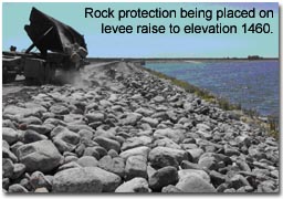
Devils Lake Levee, North Dakota
|
Location/Description
|
Devils Lake is a closed basin in semi-arid northeastern North Dakota. Depending on climatological patterns, the lake is subject to extreme variations in stage. High lake levels cause urban, agricultural, and transportation flood damages. The lake reached its highest recorded level (1449.20 feet) in May 2006 and has caused more than $300 million in flood related damages.
The levee system is about 8 miles long with a top elevation of 1460 feet above mean sea level. Although referred to as levees, the system was actually designed and constructed as a dam to hold back water for many decades. The Corps is currently working with the Federal Emergency Management Agency, the U.S. Geological Survey, and local officials to determine the level of protection that is provided by the levee elevation of 1460. Traditionally, the top 6 feet of the levee elevation serves as freeboard, or a safety factor to prevent waves or ice from splashing over it. Before the levees were built, snowmelt and rain runoff drained to the lake. Now, the interior drainage is routed to five pumping stations that pump the water over the levee.
|
|
Status
|
Work was essentially completed in December 2005 on the additional 3-foot raise that brings the levees to a top elevation of 1460. The project is monitored and maintained by the city with annual inspections by the Corps.
If the lake continues to rise, additional actions may need to be taken to protect the city of Devils Lake. The Emergency Supplemental Appropriation of 2007 included $5 million to plan and design the next levee raise. In the coming months the Corps of Engineers will work with the local community to identify possible solutions while minimizing impacts, and develop a strategy for implementation.
|
|
Additional
|
The initial levees were constructed in the 1980s to an elevation of 1445. By resolution dated June 17, 1996, the city formally requested emergency assistance from the Corps to raise the city's protection dikes an additional 5 feet to an elevation of 1450. On June 12, 1997, the city requested assistance in raising the levees to an elevation of 1457 to provide protection for a lake level of 1451. The project was approved under Public Law 84-99, Advance Measures Authority. A project cooperation agreement was signed on August 12, 1996, and amended on June 1, 1998, and August 3, 2004.
|
|
Authority
|
Public Law 84-99 Activities (Advance Measures).
|
|
Fiscal
|
Total project costs to date are estimated at $53.6 million, including the levee raise to elevation 1460.
Top of levee 1,460
Estimated federal cost $40,230,000
Estimated non-federal cost $13,410,000
Total estimated project cost $53,640,000
Planning and Design for Next Levee Raise
Estimated Federal cost $5,000,000
|
|
|
[Printable Copy]
|