| Projects & Studies
|
| »
|
Benton County near St. Cloud, Minnesota
|
| »
|
Canisteo Mine Pit Flood Control Project, Itasca County, Minn.
|
| »
|
Chippewa River at Big Bend , Minnesota - Stream Bank Protection
|
| »
|
Crow River at Delano, Minnesota
|
| »
|
Devils Lake Basin, North Dakota
|
| »
|
Devils Lake Flood Risk Management Project
|
| »
|
Devils Lake Levee, North Dakota
|
| »
|
Devils Lake: Minnewaukan Flood Control Project, North Dakota
|
| »
|
Drayton Initial Assessment - Drayton, North Dakota
|
| »
|
Emergency Streambank Protection, Section 14, Brooklyn Center, Minn.
|
| »
|
Erosion along Highway 2, Red Lake River, Crookston, MN
|
| »
|
Fargo-Moorhead and Upstream Feasibility Study
|
| »
|
Flood Control: Downtown St. Paul Airport, St. Paul, Minnesota
|
| »
|
Flood Risk Management Continuing Authority, Red River of the North: Wahpeton, N.D.
|
| »
|
Flood Risk Management: Fargo-Moorhead Metro, North Dakota and Minnesota
|
| »
|
Flood Risk Management: Red Lake River, Crookston, Minnesota
|
| »
|
Flood Risk Management: Roseau River, Roseau, Minnesota
|
| »
|
Flood Risk Management: Twin Valley, Wild Rice River, Minnesota
|
| »
|
Hay Creek Aquatic Ecosystem Restoration - Roseau County, Minnesota
|
| »
|
Homme Dam and Reservoir Dam Safety, North Dakota
|
| »
|
Integrated Watershed Study: Minnesota River Basin in Minnesota, South Dakota, North Dakota and Iowa
|
| »
|
Kickapoo River Flood Damage Reduction, La Farge, Wisconsin
|
| »
|
Lac Qui Parle River, Dawson, Minnesota
|
| »
|
Marsh Creek near Mahnomen, Minnesota
|
| »
|
Minnesota River Flood Control Project : Montevideo, Minnesota
|
| »
|
Minnesota River Flood Control Project, at Granite Falls, Minnesota
|
| »
|
Mississippi Headwaters Reservoirs Project Sites
|
| »
|
Newport, Minnesota Flood Risk Management Project, Section 205
|
| »
|
Painter Creek Habitat Restoration, Minnehaha Creek, Minnesota
|
| »
|
Park River Flood Protection Project at Grafton, North Dakota
|
| »
|
Pembina River Flood Control Project: Neche, North Dakota
|
| »
|
Reconnaissance Study: Minnesota River Basin in MN, SD, IA and ND
|
| »
|
Red River of the North Basin: Basin-Wide Watershed Management Planning
|
| »
|
Red River of the North Basin: Minnesota, North Dakota, South Dakota and Manitoba, Reconnaissance Study
|
| »
|
Red River of the North Flood Control: Breckenridge, Minnesota
|
| »
|
Red River of the North at Grand Forks, North Dakota/East Grand Forks, Minnesota Flood Risk Management
|
| »
|
Ridgewood Addition, Fargo, North Dakota
|
| »
|
River Resource Values and Expectation
|
| »
|
Roads Serving As Water Barriers, Devils Lake Basin, North Dakota
|
| »
|
Sand Creek Flood Risk Management Project, Jordan, Minnesota
|
| »
|
Section 205 Flood Control Project, Borup, Minnesota
|
| »
|
Section 205 Flood Control Study: Mississippi River, Aitkin, Minnesota
|
| »
|
Sheyenne River Flood Control, West Fargo, North Dakota
|
| »
|
Sheyenne River, Baldhill Pool Raise, North Dakota
|
| »
|
South Fork Zumbro River Flood Control: Rochester, Minnesota
|
| »
|
South Washington Watershed District
|
| »
|
Stillwater Flood and Retaining Wall Project, St. Croix River, Stillwater, Minnesota
|
| »
|
Stream Bank Protection: Section 14, Pug Hole Lake, Minnesota
|
| »
|
Western Flood Control Sites - Minnesota: Lake Traverse, Orwell Lake, Hwy 75 - Bigstone, Lac qui Parle
|
| »
|
Western Flood Control Sites – North Dakota: Lake Ashtabula, Homme Lake Souris River
|
| »
|
White Rock Dam Safety, Wheaton, Minnesota
|
| »
|
Wild Rice River (MN) Feasibility Study
|
| »
|
Wild Rice and Marsh Rivers, Ada, Minnesota
|
|
|
|
Stream Bank Protection: Section 14, Pug Hole Lake, Minnesota
|
Location/Description
|
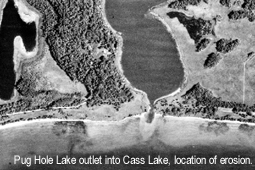
Pug Hole Lake is located in Beltrami County in northern Minnesota, approximately 215 miles northwest of St. Paul, Minn.
Approximately 2,000 feet of bank erosion is occurring at the Turtle River outflow from Pug Hole Lake. The erosion is threatening Native American owned lease lots, known cultural heritage sites and Native American burial materials, including human remains.
|
|
Status
|
The Leech Lake Band of Ojibwe requested a stream-bank protection study from the Corps of Engineers on Nov. 18, 1999.
A preliminary design has been prepared. The project is on hold pending discussion and a decision by the Band to continue. Work remaining includes the preparation of contract bid documents leading to the award of a construction contract.
|
|
Authority
|
Section 14 of the 1946 Flood Control Act, as amended.
|
|
Fiscal
|
The first $40,000 of planning, design and analysis is conducted at full federal expense. The remainder of the project cost is shared at 65-percent federal and 35-percent non-federal if the project is approved and proceeds to construction. Planning, design and analysis consist of all activities up to and including award of a construction contract.
Federal cost $79,000
Non-federal cost 21,000
Total estimated cost 100,000
|
|
|
[Printable Copy]
|