| Projects & Studies
|
| »
|
Benton County near St. Cloud, Minnesota
|
| »
|
Canisteo Mine Pit Flood Control Project, Itasca County, Minn.
|
| »
|
Chippewa River at Big Bend , Minnesota - Stream Bank Protection
|
| »
|
Crow River at Delano, Minnesota
|
| »
|
Devils Lake Basin, North Dakota
|
| »
|
Devils Lake Flood Risk Management Project
|
| »
|
Devils Lake Levee, North Dakota
|
| »
|
Devils Lake: Minnewaukan Flood Control Project, North Dakota
|
| »
|
Drayton Initial Assessment - Drayton, North Dakota
|
| »
|
Emergency Streambank Protection, Section 14, Brooklyn Center, Minn.
|
| »
|
Erosion along Highway 2, Red Lake River, Crookston, MN
|
| »
|
Fargo-Moorhead and Upstream Feasibility Study
|
| »
|
Flood Control: Downtown St. Paul Airport, St. Paul, Minnesota
|
| »
|
Flood Risk Management Continuing Authority, Red River of the North: Wahpeton, N.D.
|
| »
|
Flood Risk Management: Fargo-Moorhead Metro, North Dakota and Minnesota
|
| »
|
Flood Risk Management: Red Lake River, Crookston, Minnesota
|
| »
|
Flood Risk Management: Roseau River, Roseau, Minnesota
|
| »
|
Flood Risk Management: Twin Valley, Wild Rice River, Minnesota
|
| »
|
Hay Creek Aquatic Ecosystem Restoration - Roseau County, Minnesota
|
| »
|
Homme Dam and Reservoir Dam Safety, North Dakota
|
| »
|
Integrated Watershed Study: Minnesota River Basin in Minnesota, South Dakota, North Dakota and Iowa
|
| »
|
Kickapoo River Flood Damage Reduction, La Farge, Wisconsin
|
| »
|
Lac Qui Parle River, Dawson, Minnesota
|
| »
|
Marsh Creek near Mahnomen, Minnesota
|
| »
|
Minnesota River Flood Control Project : Montevideo, Minnesota
|
| »
|
Minnesota River Flood Control Project, at Granite Falls, Minnesota
|
| »
|
Mississippi Headwaters Reservoirs Project Sites
|
| »
|
Newport, Minnesota Flood Risk Management Project, Section 205
|
| »
|
Painter Creek Habitat Restoration, Minnehaha Creek, Minnesota
|
| »
|
Park River Flood Protection Project at Grafton, North Dakota
|
| »
|
Pembina River Flood Control Project: Neche, North Dakota
|
| »
|
Reconnaissance Study: Minnesota River Basin in MN, SD, IA and ND
|
| »
|
Red River of the North Basin: Basin-Wide Watershed Management Planning
|
| »
|
Red River of the North Basin: Minnesota, North Dakota, South Dakota and Manitoba, Reconnaissance Study
|
| »
|
Red River of the North Flood Control: Breckenridge, Minnesota
|
| »
|
Red River of the North at Grand Forks, North Dakota/East Grand Forks, Minnesota Flood Risk Management
|
| »
|
Ridgewood Addition, Fargo, North Dakota
|
| »
|
River Resource Values and Expectation
|
| »
|
Roads Serving As Water Barriers, Devils Lake Basin, North Dakota
|
| »
|
Sand Creek Flood Risk Management Project, Jordan, Minnesota
|
| »
|
Section 205 Flood Control Project, Borup, Minnesota
|
| »
|
Section 205 Flood Control Study: Mississippi River, Aitkin, Minnesota
|
| »
|
Sheyenne River Flood Control, West Fargo, North Dakota
|
| »
|
Sheyenne River, Baldhill Pool Raise, North Dakota
|
| »
|
South Fork Zumbro River Flood Control: Rochester, Minnesota
|
| »
|
South Washington Watershed District
|
| »
|
Stillwater Flood and Retaining Wall Project, St. Croix River, Stillwater, Minnesota
|
| »
|
Stream Bank Protection: Section 14, Pug Hole Lake, Minnesota
|
| »
|
Western Flood Control Sites - Minnesota: Lake Traverse, Orwell Lake, Hwy 75 - Bigstone, Lac qui Parle
|
| »
|
Western Flood Control Sites – North Dakota: Lake Ashtabula, Homme Lake Souris River
|
| »
|
White Rock Dam Safety, Wheaton, Minnesota
|
| »
|
Wild Rice River (MN) Feasibility Study
|
| »
|
Wild Rice and Marsh Rivers, Ada, Minnesota
|
|
|
|
Roads Serving As Water Barriers, Devils Lake Basin, North Dakota
|
Location/Description
|
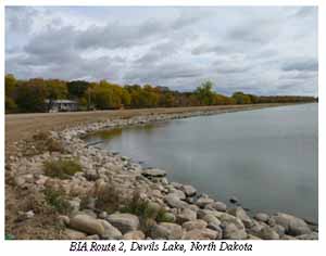
Devils Lake is in northeastern North Dakota. Throughout the 1990s, the lake level has risen drastically, inundating much of the surrounding area and having an impact on the region’s surface transportation facilities.
|
|
Background
|
In some areas, roads are being used to provide barriers to the rising and expanding waters of Devils Lake. Because the Roads Serving as Water Barriers were not constructed to function as dams, they are a potential safety problem to road users and to people living in the areas sheltered by the barriers. Many of these roads are within the Spirit Lake Indian Reservation. The Federal Highway Administration will not allow the use of Federal highway funds for any future work on these highway segments unless their safety can be verified. The Corps of Engineers cannot verify their safety without major modifications that would likely include additional embankment and methods for controlling seepage.
|
Raising the segments of road without first stabilizing them could result in a failure. If these roads are not raised, they will eventually be overtopped if lake levels continue to rise.
The language of the 2006 Transportation Bill allows the Federal Highway Administration to address this problem. The Corps of Engineers is providing technical assistance in the design and construction so the roads will both accommodate surface transportation and provide a water barrier.
|
|
Status
|
The Federal Highway Administration (Central Federal Lands Division) and Bureau of Indian Affairs are the lead agencies on this project. The Corps is committed to working with the Bureau of Indian Affairs, Spirit Lake Nation, State of North Dakota, and Federal Highway Administration to determine a solution for the Roads Serving as Water Barriers. To date, the Corps has provided technical advice, dam safety designs, and construction engineering support. Some interim repairs were completed in summer 2007. The environmental review has been completed, and the Finding of No Significant Impact was signed on June 5, 2008. The design work will continue through the winter with the objective to begin construction in spring 2009.
|
|
Authority
|
The Corps support to the Federal Highway Administration is provided under The Economy Act (31 U.S.C. 1535). Authorization for the design and construction work is provided under the Transportation Bill. It allows $70 million for this effort, not to exceed $10 million in any fiscal year.
|
|
Related Issues
|
Additional information is available at the Central Federal Lands Division website at this link: http://www.cflhd.gov/projects/StateProjectDetails.cfm?State=ND&WebProjectUID=10398
|
|
|
[Printable Copy]
|