| Projects & Studies
|
| »
|
Benton County near St. Cloud, Minnesota
|
| »
|
Canisteo Mine Pit Flood Control Project, Itasca County, Minn.
|
| »
|
Chippewa River at Big Bend , Minnesota - Stream Bank Protection
|
| »
|
Crow River at Delano, Minnesota
|
| »
|
Devils Lake Basin, North Dakota
|
| »
|
Devils Lake Flood Risk Management Project
|
| »
|
Devils Lake Levee, North Dakota
|
| »
|
Devils Lake: Minnewaukan Flood Control Project, North Dakota
|
| »
|
Drayton Initial Assessment - Drayton, North Dakota
|
| »
|
Emergency Streambank Protection, Section 14, Brooklyn Center, Minn.
|
| »
|
Erosion along Highway 2, Red Lake River, Crookston, MN
|
| »
|
Fargo-Moorhead and Upstream Feasibility Study
|
| »
|
Flood Control: Downtown St. Paul Airport, St. Paul, Minnesota
|
| »
|
Flood Risk Management Continuing Authority, Red River of the North: Wahpeton, N.D.
|
| »
|
Flood Risk Management: Fargo-Moorhead Metro, North Dakota and Minnesota
|
| »
|
Flood Risk Management: Red Lake River, Crookston, Minnesota
|
| »
|
Flood Risk Management: Roseau River, Roseau, Minnesota
|
| »
|
Flood Risk Management: Twin Valley, Wild Rice River, Minnesota
|
| »
|
Hay Creek Aquatic Ecosystem Restoration - Roseau County, Minnesota
|
| »
|
Homme Dam and Reservoir Dam Safety, North Dakota
|
| »
|
Integrated Watershed Study: Minnesota River Basin in Minnesota, South Dakota, North Dakota and Iowa
|
| »
|
Kickapoo River Flood Damage Reduction, La Farge, Wisconsin
|
| »
|
Lac Qui Parle River, Dawson, Minnesota
|
| »
|
Marsh Creek near Mahnomen, Minnesota
|
| »
|
Minnesota River Flood Control Project : Montevideo, Minnesota
|
| »
|
Minnesota River Flood Control Project, at Granite Falls, Minnesota
|
| »
|
Mississippi Headwaters Reservoirs Project Sites
|
| »
|
Newport, Minnesota Flood Risk Management Project, Section 205
|
| »
|
Painter Creek Habitat Restoration, Minnehaha Creek, Minnesota
|
| »
|
Park River Flood Protection Project at Grafton, North Dakota
|
| »
|
Pembina River Flood Control Project: Neche, North Dakota
|
| »
|
Reconnaissance Study: Minnesota River Basin in MN, SD, IA and ND
|
| »
|
Red River of the North Basin: Basin-Wide Watershed Management Planning
|
| »
|
Red River of the North Basin: Minnesota, North Dakota, South Dakota and Manitoba, Reconnaissance Study
|
| »
|
Red River of the North Flood Control: Breckenridge, Minnesota
|
| »
|
Red River of the North at Grand Forks, North Dakota/East Grand Forks, Minnesota Flood Risk Management
|
| »
|
Ridgewood Addition, Fargo, North Dakota
|
| »
|
River Resource Values and Expectation
|
| »
|
Roads Serving As Water Barriers, Devils Lake Basin, North Dakota
|
| »
|
Sand Creek Flood Risk Management Project, Jordan, Minnesota
|
| »
|
Section 205 Flood Control Project, Borup, Minnesota
|
| »
|
Section 205 Flood Control Study: Mississippi River, Aitkin, Minnesota
|
| »
|
Sheyenne River Flood Control, West Fargo, North Dakota
|
| »
|
Sheyenne River, Baldhill Pool Raise, North Dakota
|
| »
|
South Fork Zumbro River Flood Control: Rochester, Minnesota
|
| »
|
South Washington Watershed District
|
| »
|
Stillwater Flood and Retaining Wall Project, St. Croix River, Stillwater, Minnesota
|
| »
|
Stream Bank Protection: Section 14, Pug Hole Lake, Minnesota
|
| »
|
Western Flood Control Sites - Minnesota: Lake Traverse, Orwell Lake, Hwy 75 - Bigstone, Lac qui Parle
|
| »
|
Western Flood Control Sites – North Dakota: Lake Ashtabula, Homme Lake Souris River
|
| »
|
White Rock Dam Safety, Wheaton, Minnesota
|
| »
|
Wild Rice River (MN) Feasibility Study
|
| »
|
Wild Rice and Marsh Rivers, Ada, Minnesota
|
|
|
|
Pembina River Flood Control Project: Neche, North Dakota
|
Location/Description
|
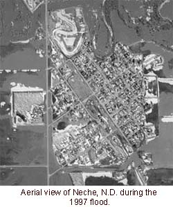
Neche is a rural community located in north-central Pembina County in northeastern North Dakota. The community lies approximately 1.5 miles south of the United States-Canada border and about 15 miles west of the North Dakota-Minnesota state line. The city lies along the south (right) side of the Pembina River approximately 34 miles upstream from its confluence with the Red River of the North. The city has experienced recurring overland flooding of residential and commercial structures, usually as a result of spring snowmelt runoff. The city has temporary protection from existing, non-federal levees. In 1999, the city constructed a channel, which bypassed the oxbow of the river closest to the city.
|
|
Status
|
The St. Paul District completed a decision report on flood control for the Pembina River at Neche, N.D.,in June 1986. Efforts are currently under way to update the decision document and initiate the preparation of plans and specifications. The proposed plan consists of an earthen levee with associated interior drainage facilities, a road raise and modification of the city-built cutoff channel. The Corps' Bismarck Regulatory Office has resolved noncompliance issues with the General Permit that was issued for the city-built cutoff channel.
The St. Paul District is currently working with the city to determine if the design of the flood control project should proceed. Once the city determines they wish to proceed, the project costs and benefits will be updated, a new environmental assessment will be completed and the plans and specifications can be prepared.
|
|
Additional
|
The project is on hold, as there is no federal or local funding to continue with project planning and design.
|
|
Authority
|
The authority for this project is provided by Section 205 of the Flood Control Act of 1948, as amended.
|
|
Fiscal
|
The letter report and the preparation of plans and specifications are initially fully federally funded with the local share recouped during the construction phase. Construction of the project is cost shared at 65 percent federal and 35 percent non-federal.
Federal cost $1,920,000
Non-federal cost $1,030,000
Total estimated cost $2,950,000
|
|
|
[Printable Copy]
|