| Projects & Studies
|
| »
|
Benton County near St. Cloud, Minnesota
|
| »
|
Canisteo Mine Pit Flood Control Project, Itasca County, Minn.
|
| »
|
Chippewa River at Big Bend , Minnesota - Stream Bank Protection
|
| »
|
Crow River at Delano, Minnesota
|
| »
|
Devils Lake Basin, North Dakota
|
| »
|
Devils Lake Flood Risk Management Project
|
| »
|
Devils Lake Levee, North Dakota
|
| »
|
Devils Lake: Minnewaukan Flood Control Project, North Dakota
|
| »
|
Drayton Initial Assessment - Drayton, North Dakota
|
| »
|
Emergency Streambank Protection, Section 14, Brooklyn Center, Minn.
|
| »
|
Erosion along Highway 2, Red Lake River, Crookston, MN
|
| »
|
Fargo-Moorhead and Upstream Feasibility Study
|
| »
|
Flood Control: Downtown St. Paul Airport, St. Paul, Minnesota
|
| »
|
Flood Risk Management Continuing Authority, Red River of the North: Wahpeton, N.D.
|
| »
|
Flood Risk Management: Fargo-Moorhead Metro, North Dakota and Minnesota
|
| »
|
Flood Risk Management: Red Lake River, Crookston, Minnesota
|
| »
|
Flood Risk Management: Roseau River, Roseau, Minnesota
|
| »
|
Flood Risk Management: Twin Valley, Wild Rice River, Minnesota
|
| »
|
Hay Creek Aquatic Ecosystem Restoration - Roseau County, Minnesota
|
| »
|
Homme Dam and Reservoir Dam Safety, North Dakota
|
| »
|
Integrated Watershed Study: Minnesota River Basin in Minnesota, South Dakota, North Dakota and Iowa
|
| »
|
Kickapoo River Flood Damage Reduction, La Farge, Wisconsin
|
| »
|
Lac Qui Parle River, Dawson, Minnesota
|
| »
|
Marsh Creek near Mahnomen, Minnesota
|
| »
|
Minnesota River Flood Control Project : Montevideo, Minnesota
|
| »
|
Minnesota River Flood Control Project, at Granite Falls, Minnesota
|
| »
|
Mississippi Headwaters Reservoirs Project Sites
|
| »
|
Newport, Minnesota Flood Risk Management Project, Section 205
|
| »
|
Painter Creek Habitat Restoration, Minnehaha Creek, Minnesota
|
| »
|
Park River Flood Protection Project at Grafton, North Dakota
|
| »
|
Pembina River Flood Control Project: Neche, North Dakota
|
| »
|
Reconnaissance Study: Minnesota River Basin in MN, SD, IA and ND
|
| »
|
Red River of the North Basin: Basin-Wide Watershed Management Planning
|
| »
|
Red River of the North Basin: Minnesota, North Dakota, South Dakota and Manitoba, Reconnaissance Study
|
| »
|
Red River of the North Flood Control: Breckenridge, Minnesota
|
| »
|
Red River of the North at Grand Forks, North Dakota/East Grand Forks, Minnesota Flood Risk Management
|
| »
|
Ridgewood Addition, Fargo, North Dakota
|
| »
|
River Resource Values and Expectation
|
| »
|
Roads Serving As Water Barriers, Devils Lake Basin, North Dakota
|
| »
|
Sand Creek Flood Risk Management Project, Jordan, Minnesota
|
| »
|
Section 205 Flood Control Project, Borup, Minnesota
|
| »
|
Section 205 Flood Control Study: Mississippi River, Aitkin, Minnesota
|
| »
|
Sheyenne River Flood Control, West Fargo, North Dakota
|
| »
|
Sheyenne River, Baldhill Pool Raise, North Dakota
|
| »
|
South Fork Zumbro River Flood Control: Rochester, Minnesota
|
| »
|
South Washington Watershed District
|
| »
|
Stillwater Flood and Retaining Wall Project, St. Croix River, Stillwater, Minnesota
|
| »
|
Stream Bank Protection: Section 14, Pug Hole Lake, Minnesota
|
| »
|
Western Flood Control Sites - Minnesota: Lake Traverse, Orwell Lake, Hwy 75 - Bigstone, Lac qui Parle
|
| »
|
Western Flood Control Sites – North Dakota: Lake Ashtabula, Homme Lake Souris River
|
| »
|
White Rock Dam Safety, Wheaton, Minnesota
|
| »
|
Wild Rice River (MN) Feasibility Study
|
| »
|
Wild Rice and Marsh Rivers, Ada, Minnesota
|
|
|
|
Ridgewood Addition, Fargo, North Dakota
|
Location/Description
|
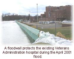
The project is located on the north side of Fargo, N.D, along the west bank of the Red River of the North. It would protect the Department of Veterans Affairs hospital and that portion of Fargo between 15th Avenue North and 22nd Avenue North. Approximately one-third of the project is located on federal land managed by the U.S. Department of Veterans Affairs. The project consists of levees, floodwalls and associated interior drainage structures.
High ground at the ends of the project is at elevation 899.5 feet msl. The plan that maximizes net economic benefits, called the National Economic Development plan, would be built to elevation 899.5 feet msl. The city and the VA prefer an alternative that would provide a flood barrier at elevation 902.6 feet msl. The additional 3.1 feet would facilitate flood-fighting activities for floods larger than a 40-year event. The locally preferred plan is the recommended plan.
|
|
Status
|
More than $4.5 million dollars in federal funding has been provided since fiscal year 2007 for the city portion of the project. The review of the nonstandard Project Partnership Agreement by the Assistant Secretary of the Army (Civil Works) was completed in January 2008. The agreement was executed in April 2008. Plans and specifications were completed in April 2008, and the construction contract for the city portion of the project was awarded in August 2008 with construction completion by spring 2010.
The Assistant Secretary of the Army (Civil Works) office approved the locally preferred plan in March 2005. In July 2007, construction work was started on the VA portion of the project and construction was substantially complete by August 2008.
|
|
Authority
|
The authority for the project is provided by Section 205 of the 1948 Flood Control Act, as amended. The Chief of Engineers, under the supervision of the Assistant Secretary of the Army (Civil Works), is authorized under 10 U.S.C. Sec. 3036(d) to provide services to the VA for construction of the VA’s portion of the project on a reimbursable basis.
|
|
Fiscal
|
The feasibility study cost was $634,700. The federal portion provides for the first $100,000 of study costs. The remaining study cost was split equally with the city of Fargo. The VA is responsible for 100 percent of all design and construction costs for features located on VA property. For features not on VA property, the final design and construction cost is shared, with the city contributing a minimum of 35 percent and the federal government contributing the remainder. The city must also pay 100 percent of costs for locally preferred project features.
Current implementation costs are estimated as follows:
City of Fargo $ 4,400,000
Corps of Engineers $ 5,155,000
VA $ 5,100,000
Total $14,655,000
|
|
|
[Printable Copy]
|