| Projects & Studies
|
| »
|
Benton County near St. Cloud, Minnesota
|
| »
|
Canisteo Mine Pit Flood Control Project, Itasca County, Minn.
|
| »
|
Chippewa River at Big Bend , Minnesota - Stream Bank Protection
|
| »
|
Crow River at Delano, Minnesota
|
| »
|
Devils Lake Basin, North Dakota
|
| »
|
Devils Lake Flood Risk Management Project
|
| »
|
Devils Lake Levee, North Dakota
|
| »
|
Devils Lake: Minnewaukan Flood Control Project, North Dakota
|
| »
|
Drayton Initial Assessment - Drayton, North Dakota
|
| »
|
Emergency Streambank Protection, Section 14, Brooklyn Center, Minn.
|
| »
|
Erosion along Highway 2, Red Lake River, Crookston, MN
|
| »
|
Fargo-Moorhead and Upstream Feasibility Study
|
| »
|
Flood Control: Downtown St. Paul Airport, St. Paul, Minnesota
|
| »
|
Flood Risk Management Continuing Authority, Red River of the North: Wahpeton, N.D.
|
| »
|
Flood Risk Management: Fargo-Moorhead Metro, North Dakota and Minnesota
|
| »
|
Flood Risk Management: Red Lake River, Crookston, Minnesota
|
| »
|
Flood Risk Management: Roseau River, Roseau, Minnesota
|
| »
|
Flood Risk Management: Twin Valley, Wild Rice River, Minnesota
|
| »
|
Hay Creek Aquatic Ecosystem Restoration - Roseau County, Minnesota
|
| »
|
Homme Dam and Reservoir Dam Safety, North Dakota
|
| »
|
Integrated Watershed Study: Minnesota River Basin in Minnesota, South Dakota, North Dakota and Iowa
|
| »
|
Kickapoo River Flood Damage Reduction, La Farge, Wisconsin
|
| »
|
Lac Qui Parle River, Dawson, Minnesota
|
| »
|
Marsh Creek near Mahnomen, Minnesota
|
| »
|
Minnesota River Flood Control Project : Montevideo, Minnesota
|
| »
|
Minnesota River Flood Control Project, at Granite Falls, Minnesota
|
| »
|
Mississippi Headwaters Reservoirs Project Sites
|
| »
|
Newport, Minnesota Flood Risk Management Project, Section 205
|
| »
|
Painter Creek Habitat Restoration, Minnehaha Creek, Minnesota
|
| »
|
Park River Flood Protection Project at Grafton, North Dakota
|
| »
|
Pembina River Flood Control Project: Neche, North Dakota
|
| »
|
Reconnaissance Study: Minnesota River Basin in MN, SD, IA and ND
|
| »
|
Red River of the North Basin: Basin-Wide Watershed Management Planning
|
| »
|
Red River of the North Basin: Minnesota, North Dakota, South Dakota and Manitoba, Reconnaissance Study
|
| »
|
Red River of the North Flood Control: Breckenridge, Minnesota
|
| »
|
Red River of the North at Grand Forks, North Dakota/East Grand Forks, Minnesota Flood Risk Management
|
| »
|
Ridgewood Addition, Fargo, North Dakota
|
| »
|
River Resource Values and Expectation
|
| »
|
Roads Serving As Water Barriers, Devils Lake Basin, North Dakota
|
| »
|
Sand Creek Flood Risk Management Project, Jordan, Minnesota
|
| »
|
Section 205 Flood Control Project, Borup, Minnesota
|
| »
|
Section 205 Flood Control Study: Mississippi River, Aitkin, Minnesota
|
| »
|
Sheyenne River Flood Control, West Fargo, North Dakota
|
| »
|
Sheyenne River, Baldhill Pool Raise, North Dakota
|
| »
|
South Fork Zumbro River Flood Control: Rochester, Minnesota
|
| »
|
South Washington Watershed District
|
| »
|
Stillwater Flood and Retaining Wall Project, St. Croix River, Stillwater, Minnesota
|
| »
|
Stream Bank Protection: Section 14, Pug Hole Lake, Minnesota
|
| »
|
Western Flood Control Sites - Minnesota: Lake Traverse, Orwell Lake, Hwy 75 - Bigstone, Lac qui Parle
|
| »
|
Western Flood Control Sites – North Dakota: Lake Ashtabula, Homme Lake Souris River
|
| »
|
White Rock Dam Safety, Wheaton, Minnesota
|
| »
|
Wild Rice River (MN) Feasibility Study
|
| »
|
Wild Rice and Marsh Rivers, Ada, Minnesota
|
|
|
|
Kickapoo River Flood Damage Reduction, La Farge, Wisconsin
|
Location/Description
|
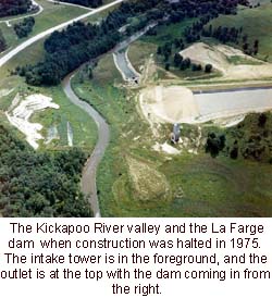
The La Farge Project is located in the southwestern corner of Wisconsin, 1 mile north of La Farge, Wis., in Vernon County. La Farge is located approximately 40 miles southeast of La Crosse, Wis. The project lands were acquired in the late 1960s and early 1970s for the construction of a flood control reservoir. The federal government acquired 8,569 acres in fee title, with an additional 459 acres subject to restrictive flowage easements.
Project construction was halted in 1975 as a result of environmental and economic concerns. The Water Resources Development Act of 1996 provided for the transfer of these properties to the state of Wisconsin and the Department of the Interior, to be held in trust for the Ho-Chunk Nation. The Ho-Chunk Nation has received 1,200 acres of culturally and religiously significant property. The remaining 7,369 acres have been transferred to the state of Wisconsin and are being managed by the Department of Tourism. Flowage easements have been released to the underlying landowners.
|
|
Status
|
In accordance with the Water Resources Development Act 1996, the state of Wisconsin and the Ho-Chunk Nation signed a Memorandum of Understanding on Oct. 30, 1997. The memorandum identified the lands to be transferred to the Secretary of the Interior and stipulated that the project lands shall be preserved in their natural state and developed only to the extent necessary to enhance outdoor recreation and educational opportunities. The memorandum includes a management plan for the project lands and contains a provision for future review of culturally and religiously significant sites.
Site safety work has been completed on the water control features. Remediation of the abandoned farm sites and wells on the project lands is complete. Land transfer to the state of Wisconsin and the Department of the Interior has been completed.
|
|
Additional
|
The Wisconsin Department of Transportation, working with the Vernon County Highway Department, has completed the highway relocations. A dedication ceremony for the highway work was held on Aug. 15, 2003. The Corps of Engineers has reimbursed the Wisconsin Department of Transportation and the county for the highway relocation work.
|
|
Authority
|
Section 203 of the Flood Control Act of 1962 (76 Stat. 1190) as modified by Section 814 of WRDA 1986 (100 Stat. 4169), and further modified by Section 361 of WRDA 1996.
|
|
Fiscal
|
Project design and construction costs are 100 percent federal. Current operation and maintenance costs are 100 percent non-federal for the land transferred to the state and the land held in trust by the Department of the Interior for the Ho-Chunk Nation. The Fiscal Year 2003 appropriation of $4,361,000 completed the project.
Federal cost $17,000,000
Non-federal cost $ 2,900,000
Total estimated project cost $19,900,000
|
|
|
[Printable Copy]
|