| Projects & Studies
|
| »
|
Flood Risk Management Continuing Authority, Red River of the North: Wahpeton, N.D.
|
| »
|
Integrated Watershed Study: Minnesota River Basin in Minnesota, South Dakota, North Dakota and Iowa
|
| »
|
Lower St. Anthony Falls Rapids Restoration, Mississippi River, Minneapolis, Minn.
|
| »
|
Mississippi Headwaters Reservoirs Project Sites
|
| »
|
Mississippi Place, Mississippi River, St. Paul, Minn.
|
| »
|
Mississippi River Recreation and Environmental Stewardship, Eau Galle Dam
|
| »
|
Reconnaissance Study: Minnesota River Basin in MN, SD, IA and ND
|
| »
|
Recreational Boating Study of the Mississippi River, Pools 4 to 9, Summer 2003
|
| »
|
River Resource Values and Expectation
|
| »
|
Western Flood Control Sites - Minnesota: Lake Traverse, Orwell Lake, Hwy 75 - Bigstone, Lac qui Parle
|
| »
|
Western Flood Control Sites – North Dakota: Lake Ashtabula, Homme Lake Souris River
|
|
|
|
Reconnaissance Study: Minnesota River Basin in MN, SD, IA and ND
|
Location/Description
|
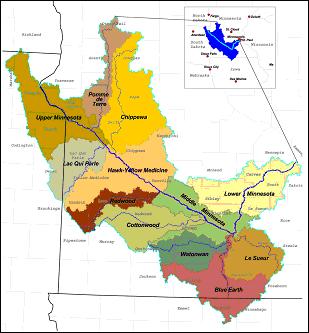
The Minnesota River originates in southwestern Minnesota at the Minnesota-South Dakota border. The river drains 16,770 square miles in Minnesota, South Dakota, North Dakota and Iowa. It flows 335 miles to join the Mississippi River at Minneapolis, Minnesota. Since European settlement, native prairie has been replaced by agriculture and urban development with constructed drainage systems; more than 90 percent of the wetlands that existed pre-settlement have been drained. Several dams prevent natural fish migrations. A navigation channel in the lower 15 miles of the river passes through the Minnesota Valley National Wildlife Refuge. The Minnesota River carries substantial sediment and nutrient loads that degrade the aquatic ecosystems in the Minnesota and Mississippi Rivers.
A reconnaissance study approved in January 2005 recommended three initial feasibility studies. Two ecosystem restoration feasibility studies have been initiated: Blue Earth River and Marsh Lake.
The third recommended study is an integrated watershed study that would produce a watershed management plan and decision support system. The study would integrate the actions of local, State and Federal stakeholders to better manage water resources in the Minnesota River basin. It would assist in setting realistic goals for the watershed and would identify specific opportunities for the Corps of Engineers and other stakeholders to implement to achieve those goals.
|
Additional reconnaissance efforts will be considered as needs arise.
|
|
Status
|
Scoping is underway for the proposed integrated watershed study. The reconnaissance report was approved January 13, 2005.
|
|
Authority
|
A resolution of the Committee on Public Works of the U.S. House of Representatives, May 10, 1962, to determine the advisability of further improvements in the Minnesota River basin for navigation, flood control, recreation, low-flow augmentation, and other related water and land resources.
|
|
Fiscal
|
Estimated federal cost $514,000
Estimated non-federal cost 0
Total estimated cost $514,000
Federal Appropriation through fiscal year 2007 $349,000
Fiscal year 2008 federal appropriation $40,000
Total $389,000
|
|
|
[Printable Copy]
|