| Projects & Studies
|
| »
|
Ambrough Slough Habitat Project, Pool 10, Wisconsin
|
| »
|
Aquatic Ecosystem Restoration: Section 206, Paint Creek Restoration, Waukon, Iowa
|
| »
|
Asian Carp Barrier System Upper Mississippi River
|
| »
|
Blackhawk Park Backwater Restoration Project , Victory, Wisconsin
|
| »
|
Bussey Lake Habitat Project, Guttenberg, Iowa
|
| »
|
Capoli Slough Habitat Project, Pool 9, Wisconsin
|
| »
|
Christine and Hickson Dams
|
| »
|
Cold Springs Habitat Project, Crawford County, Wis.
|
| »
|
Conway Lake Habitat Project, Lansing, Iowa
|
| »
|
Drayton Dam Habitat Restoration, Drayton, North Dakota
|
| »
|
Dresbach Island Revegetation Project
|
| »
|
East Channel Habitat Project, La Crescent, Minn./Wis.
|
| »
|
Endangered Species - Conservation of Native Mussels
|
| »
|
Environmental Infrastructure Assistance - City of Garrison and Kathio Township, Minnesota
|
| »
|
Environmental Infrastructure Assistance Program: Section 219 - Devils Lake and All of North Dakota
|
| »
|
Environmental Infrastructure Assistance Program: Section 219 at Central Lakes, Goodview, Grand Rapids, Willmar, Minnesota
|
| »
|
Environmental Infrastructure Assistance Program: St. Croix Falls, Wisconsin
|
| »
|
Fargo-Moorhead and Upstream Feasibility Study
|
| »
|
Feasibility Study: Blue Earth River Basin in Minnesota and Iowa
|
| »
|
Finger Lakes Habitat Project , Wabasha, Minnesota
|
| »
|
General Investigations: Hydropower, Crown Hydro, Minneapolis, Minnesota
|
| »
|
General Investigations: Hydropower, Ford Plant, Minneapolis, Minnesota
|
| »
|
Grand Marais River Aquatic Ecosystem Restoration
|
| »
|
Guttenberg Waterfowl Ponds Habitat Project, Iowa
|
| »
|
Habitat Restoration: Mississippi River, Pool 8 Islands Phase III, Wisconsin/Minnesota
|
| »
|
Habitat Restoration: Mississippi River, Clear (Finger) Lake, Pool 5, Minnesota
|
| »
|
Harpers Slough Habitat Project, Pool 9, Iowa
|
| »
|
Hay Creek Aquatic Ecosystem Restoration - Roseau County, Minnesota
|
| »
|
Indian Slough Habitat Project, Buffalo County, Wis.
|
| »
|
Integrated Watershed Study: Minnesota River Basin in Minnesota, South Dakota, North Dakota and Iowa
|
| »
|
Island 116 Channel Closure & Shoreline Stabilization
|
| »
|
Island 42 Habitat Project, Wabasha County, Minn.
|
| »
|
Kinnickinnic River Aquatic Ecosystem Restoration
|
| »
|
Lake Onalaska Habitat Project, La Crosse, Wisconsin
|
| »
|
Lake Winneshiek Habitat Project, Ferryville, Wis.
|
| »
|
Lansing Big Lake Habitat Project, Lansing, Iowa
|
| »
|
Long Lake Habitat Project , Trempealeau, Wisconsin
|
| »
|
Long Meadow Lake Habitat Project, Bloomington, Minn.
|
| »
|
Lower St. Anthony Falls Rapids Restoration, Mississippi River, Minneapolis, Minn.
|
| »
|
Marsh Lake Ecosystem Restoration Feasibility Study, Lac Qui Parle Wildlife Area, MN
|
| »
|
McGregor Lake Habitat Project, Prairie du Chien, Wisconsin
|
| »
|
Minnehaha Creek Watershed Study
|
| »
|
Mississippi River Bank Stabilization Habitat Project, Minn/Wis/Iowa
|
| »
|
Mississippi River Locks and Dams Nos. 2-10 Embankment Rehabilitation
|
| »
|
Mississippi River Recreation and Environmental Stewardship, Eau Galle Dam
|
| »
|
Mississippi River: Lock & Dam 3 Navigation Safety and Embankments, Minnesota and Wisconsin
|
| »
|
Mud Lake Water Management
|
| »
|
North Ottawa Impoundment Project, Grant County, Minn.
|
| »
|
Orr, Minnesota Water Line Replacement - Section 569 Environmental Infrastructure Program
|
| »
|
Painter Creek Habitat Restoration, Minnehaha Creek, Minnesota
|
| »
|
Peterson Lake Habitat Project, Wabasha, Minnesota
|
| »
|
Pigs Eye Habitat Restoration Lake, St. Paul, Minnesota
|
| »
|
Polander Lake Habitat Project, Winona, Minnesota
|
| »
|
Pool 8 Islands Phase I Habitat Project, Wisconsin
|
| »
|
Pool 8 Islands Phase II Habitat Project, Stoddard, Wis.
|
| »
|
Pool 9 Island Habitat Project, Wisconsin
|
| »
|
Pool Slough Habitat Project, New Albin, Iowa
|
| »
|
Reconnaissance Report: Baraboo/Wisconsin River
|
| »
|
Reconnaissance Study: Minnesota River Basin in MN, SD, IA and ND
|
| »
|
Recreational Boating Study of the Mississippi River, Pools 4 to 9, Summer 2003
|
| »
|
Red Lake River/Zah Gheeng Marsh Projects, Clearwater County, Minn.
|
| »
|
Red River of the North Basin: Basin-Wide Watershed Management Planning
|
| »
|
Red River of the North Basin: Minnesota, North Dakota, South Dakota and Manitoba, Reconnaissance Study
|
| »
|
Rice Lake Habitat Project, Savage, Minnesota
|
| »
|
River Resource Values and Expectation
|
| »
|
Ruffy Brook Aquatic Ecosystem Restoration, Clearwater County, Minnesota
|
| »
|
Sand Hill River Aquatic Ecosystem Restoration, Minn.
|
| »
|
Small Scale Drawdown Habitat Project, Buffalo City, Wis.
|
| »
|
South Washington Watershed District
|
| »
|
Spring Lake Islands Habitat Project, Buffalo City, Wis.
|
| »
|
Spring Lake Peninsula Habitat Project, Buffalo City, Wis.
|
| »
|
St. Croix Headwaters Watershed Study, Wisconsin
|
| »
|
St. Croix River: Endangered Mussel Conservation - Zebra Mussel Control
|
| »
|
St. Croix Watershed Reconnaissance Study
|
| »
|
Streambank Protection: Section 14 Minnehaha Creek WPA Walls, Minnesota
|
| »
|
Streambank Protection: Section 14, Barnes County, Kathryn, North Dakota
|
| »
|
Streambank Protection: Section 14, Pug Hole Lake, Minnesota
|
| »
|
Streambank Protection: Section 14, Sartell, Minnesota
|
| »
|
Sturgeon Lake, Pine County, Minnesota, Wastewater Collection and Treatement Facility
|
| »
|
Sunrise River Watershed Study, Minnesota
|
| »
|
Trempealeau National Wildlife Refuge, Trempealeau, Wis
|
| »
|
Upper Mississippi River - Illinois Waterway System Navigation Study
|
| »
|
Upper St. Croix Lake Sanitary District Wastewater Collection Systems Improvement Project
|
| »
|
WKTY-AM Study Area
|
| »
|
Western Flood Control Sites - Minnesota: Lake Traverse, Orwell Lake, Hwy 75 - Bigstone, Lac qui Parle
|
| »
|
Western Flood Control Sites – North Dakota: Lake Ashtabula, Homme Lake Souris River
|
| »
|
Wild Rice River (MN) Feasibility Study
|
| »
|
Wild Rice River Aquatic Ecosystem Restoration, Minn.
|
| »
|
Zebra Mussels and Management Implications for Endangered Freshwater Mussels on the Upper Mississippi River System
|
|
|
|
Grand Marais River Aquatic Ecosystem Restoration
|
Location/Description
|
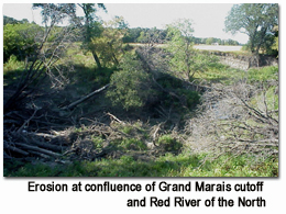
The Grand Marais River is a tributary of the Red River of the North. The study area is located in a rural setting about 7 miles north of East Grand Forks, Minn., and 275 miles northwest of Minneapolis.
A joint State-county project in 1909 constructed a 1-and-a-quarter mile-long cutoff to the Red River of the North to eliminate alleged public health nuisance problems associated with standing water at the mouth of the Grand Marais River. This cutoff abandoned the downstream-most 6-plus miles of the Grand Marais River's natural channel, which resulted in the loss of aquatic and riparian habitat. The ditched cutoff itself has relatively little aquatic habitat value, and the faster flows in the steeper cutoff cause downcutting and accelerated bank erosion in the cutoff, adversely affecting adjacent properties. In addition, headcutting is progressing upstream of the cutoff and severely degrading aquatic habitat in the Grand Marais River.
|
A number of alternative corrective measures will be considered in detail in the feasibility study; however, the preliminary restoration plan evaluated just one combination of measures – removing the plug that blocks Grand Marais River flows from going down the historic natural outlet channel, installing a weir in the cutoff to divert low flows into the historic natural channel (with larger flows split between the cutoff and the natural outlet), removing sediment in the abandoned natural outlet to restore the flow path, installing grade and erosion control structures, installing 10-foot by 10 foot culverts for township and farmstead road crossings and establishing 150 foot-wide buffer strips along each side of the old natural outlet to create a riparian corridor.
|
|
Status
|
The project is on hold until federal funding becomes available. The Red Lake Watershed District requested the project by letter dated Nov. 24, 1999. The Corps of Engineers approved the preliminary restoration plan in May 2003. The preliminary restoration plan was also distributed to the Red Lake Watershed District, federal and state agencies, landowners and other stakeholders potentially affected by the study area's problems and corrective measures.
|
|
Authority
|
Section 206 of the 1996 Water Resources Development Act, as amended.
|
|
Fiscal
|
The estimated cost for the plan identified in the preliminary restoration plan is $1,972,000. The 35-percent non-federal share includes lands, easements, rights-of-way, relocations and disposal sites. The Red Lake Watershed District will be the non-federal Sponsor.
Estimated federal cost $1,281,800
Estimated non-federal cost $ 690,200
Total estimated cost $1,972,000
|
|
|
[Printable Copy]
|