1492: An Ongoing Voyage
HOME - What
Came To Be Called "America" - Mediterranean World
- Christopher Columbus
Inventing America - Europe
Claims America - Epilogue
Exhibition Overview - Learn
More About It - Online
Exhibit Credits
 INVENTING
AMERICA INVENTING
AMERICA
The name America was given to the Western
Hemisphere by a European writer and mapmaker after Columbus' death.
Nothing in their experiences had led the first explorers to realize
that they had come into contact with a vast and unrecorded continent,
many times the size of Europe. Previously there had been no accounts,
or even rumors, of the "unknown" peoples of this "new" continent in
European scholarly literature and discussion or in popular chronicles.
Mediterranean explorers in search of
the spices and riches of the Far East initially believed that they had
reached Asia. In part due to this confusion, Europeans conjured up or
"invented" images and tales to explain America that would conform to
the descriptions of Marco Polo and others.
In early allegorical images, "America"
was sometimes portrayed as a noble, native woman submissively awaiting
European arrival. Ferocious sea animals and exotic creatures filled
early maps of the region. Regrettably, we still have incomplete knowledge
of the world view and everyday life of the varied peoples of the Americas
before European settlement.
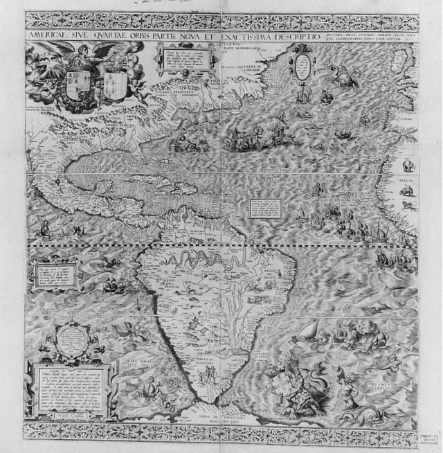
Spain in America
The Gutiérrez map depicts what appears
to be the Holy Roman Emperor, Charles V (Charles I of Spain), as the
reborn Caesar in his chariot crossing the Atlantic to lay claim to America.
Mediterranean explorers had broken open the "gates of Gilbraltar", considered
by the ancient Romans to be the westernmost limit of their empire. They
revealed a "fourth continent" across the Atlantic and a whole new world
of potential for the modern empire builders.
The map contains information available
in 1554 at the Casa de Contratación in Seville, which
regulated travel to the Western Hemisphere.
To Europeans, most of the interior of
America was still terra incognita (unknown land). Diego Gutiérrez
filled it in with a mixture of real and highly fanciful images. The
map highlights the course of the Amazon River and the location of the
silver mines of Potosí.
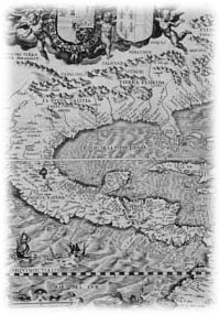
 First Map of California
Americae sive quartae orbis partis nova et exactissima descriptio
[Map of America].
By Diego Gutiérrez, 1562.
Geography and Map Division
The Gutiérrez map, which relies
upon the collection of data acquired by Spain on America, contains the
most up-to-date information on the people, settlements, and other geographical
features of the Atlantic and Gulf coasts of North America, all of Central
and South America, and portions of the western coast of Africa. Although
no coordinates appear, the map details an area roughly between 0 and
115 degrees longitude west of Greenwich and 57 degrees north and 70
degrees south latitude. Six separately engraved sheets are neatly joined
to form the largest printed map of the Western Hemisphere up to that
time (36.75 inches by 33.5 inches).
The map provides a grand view of an
America filled with images and names that had been popularized in Europe
over seventy years: parrots, monkeys, mermaids, huge sea creatures,
Brazilian cannibals, Patagonian giants, and an erupting volcano in central
Mexico complement the settlements, rivers, mountains, and capes. Although
containing fanciful imagery, Gutiérrez's map did correctly recognize
the existence of the Amazon River system, other rivers of South America,
Lake Titicaca, the location of Potosí, and the myriad coastal
features of South, Central, North, and Caribbean America. It was the
last printed Spanish map of America to appear before the late seventeenth
century. It was also the first map of America to include the name of
California.
HOME - What
Came To Be Called "America" - Mediterranean World
- Christopher Columbus
Inventing America - Europe
Claims America - Epilogue
Exhibition Overview - Learn
More About It - Online
Exhibit Credits
Exhibits Home Page
- Library of Congress Home Page
 Library
of Congress Library
of Congress
Contact
Us (
July 5, 2005 )
|