Woods Hole Science Center
Massachusetts Bay | ||||||
Geologic Mapping Home Completed Mapping Stellwagen Bank NMS Mass Bay Disposal Site Western Mass Bay Massachusetts Bay CZM-USGS Coop Nahant-Gloucester Boston Harbor Outer Cape Cod Quicks Hole Current Mapping CZM-USGS Coop Cape Ann- Salisbury Beach Duxbury-Hull Sagamore-Duxbury Jeffreys Ledge Ocean Management Mapping Technology Bibliography of Maps Selected Links Cruises Completed Upcoming |
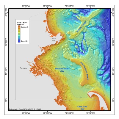
This mapping combines the data collected on multibeam surveys of the Stellwagen Bank National Marine Sanctuary and Western Massachusetts Bay to produce a map of the Massachusetts Bay. The map also utilizes data from the NOAA Coastal Relief Model for nearshore areas and the USGS Digital Elevation Model for the land. The multibeam surveys were carried out from the fall of 1994 to the fall of 1998 using a Simrad EM-1000 multibeam echo sounder. Cooperators: National Oceanic and Atmospheric Administration (NOAA), University of New Brunswick (UNB), Canadian Hydrographic Service (CHS).
Maps and Data Published as:
Butman, Bradford, Valentine, P.C., Danforth, W.W., Hayes, Laura, Serrett, L.A., and Middleton, T.J., 2004, Shaded relief, backscatter intensity and sea floor topography of Massachusetts Bay and the Stellwagen Bank region, offshore of Boston, Massachusetts. U.S. Geological Survey Geologic Investigation Map I-2734, scale 1:125,000. 2 sheets. Also available online at http://pubs.usgs.gov/imap/i2734
Butman, B., Valentine, P.C., Middleton, T.J., and Danforth, W.W., 2007, A GIS Library of multibeam data for Massachusetts Bay and the Stellwagen Bank National Marine Sanctuary, Offshore of Boston, Massachusetts. U.S. Geological Survey Data Series 99. 1 DVD-ROM. Also online at http://pubs.usgs.gov/ds/99/ See list of publications from Massachusetts Bay Mapping for links to paper maps for Quadrangles 1 and 2. For more information:
Bradford Butman, Page Valentine |
|||||