


|
Print Page | ||||||
| Ukiah Field Office | |||||||
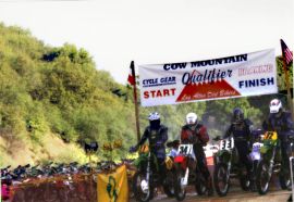
Cow Mountain Recreation AreaNamed for the longhorn cattle that once roamed wild, the 52,000-acre Cow Mountain Recreation Area offers a variety of recreational opportunities. The terrain is rugged, consisting mostly of steep, chaparral-covered slopes with scattered stands of fir, pine and oak. Elevations range from 800 to 4,000 feet. The area offers beautiful views of Ukiah and Clear Lake, over 31 miles of stream, 13 wildlife reservoirs, and habitat for blacktail deer, bear, wild turkey, and other upland species. The Recreation Area is divided into three management sections to provide quality recreational opportunities for a wide variety of users: North Cow Mountain Recreation Area, South Cow Mountain OHV Recreation Area and the Sheldon Creek Recreation Site. Access roads into these areas are narrow and winding. Travel trailers and large recreational vehicles are not recommended.
The South Cow Mountain area is subject to closure during periods of wet weather. During the rainy season, call (707)468-4000 24 hours a day for current conditions before you come.
Mayacmas Campground (north): In Ukiah, exit U.S. 101 South at Talmage Road, then 1.5 miles east to Eastside Road. Turn right and proceed 0.3 mile to Mill Creek Road. Turn left and proceed 3 miles to Mendo Rock Road, and follow to site, about 10 miles. This is a primitive recreation site. 6 units, barbecue grates, pit toilets. There is no potable water Goat Rock (north): In Ukiah, exit U.S. 101 South at Talmage Road, then 1.5 miles east to Eastside Road. Turn right and proceed 0.3 mile to Mill Creek Road. Turn left and proceed 3 miles to Mendo Rock Road, park at Mendo Rock Road. Take Glen Eden trail east about 4 miles: hiking or horseback access only. There are 2 units, picnic tables, fire grates/BBQ, and water for animals only. Red Mountain Campground (south): In Ukiah, exit U.S. 101 South at Talmage Road, then 1.5 miles east to Eastside Road. Turn right and proceed 0.3 mile to Mill Creek Road. Follow Mill Creek Road 5 miles to staging area, veer right where road forks (there is a directional sign) and continue 2.5 miles to Red Mountain Campground. 10 units, toilets, barbecue grates, and picnic tables. There is no potable water at this time. Buckhorn (south): In Ukiah, exit U.S. 101 South at Talmage Road, then 1.5 miles east to Eastside Road. Turn right and proceed 0.3 mile to Mill Creek Road. Follow Mill Creek Road 5 miles to staging area, veer right where road forks (there is a directional sign) and continue about 3.5 miles on turning at the trail #20. There are 4 units, picnic tables, fire grates/BBQs, and toilet facilities. There is no potable water. Sheldon Creek (detached): U.S. 101 to Hopland Road in Hopland, east 3 miles to Old Toll Road, 8 miles south on a gravel road. There are 6 units, toilet facilities, picnic tables, and fire grates/BBQs. This is a primitive recreation site. There is no potable water.
Click here to view recreation regulations
Bureau of Land Management |
|||||||


 - North Cow Mountain Recreation Area is managed for primarily non-motorized activities, such as hunting, hiking, camping, horseback riding, and mountain bicycling. There is
  Camping and Lodging