| |
Fascinating maps are hidden
among the American Memory digital treasures. Have fun exploring
these samples with your students and keep searching - perhaps
you will locate some unique maps on your own!
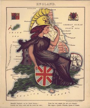
Featured Map: Using this 1868 book, Geographical
Fun, let's explore how unusual maps could be used in
the classroom. This collection of 12 humorous caricature
maps
was created by a young girl trying to amuse her ill brother.
Click on the caption below the map to link to bibliographic
information and all pages in the book. Click on the image
itself to explore the zoom view of England. Who is the
woman
caricatured in the map? What was her role in England in
1868? Read the verse underneath the map. What does this
verse
mean? Locate the flag and coats of arms? What countries do
they represent? Have names of ports, cities or bodies of
water
changed since 1868? Explore the other 11 country maps in
a similar fashion.
Learning More: Follow the links on the right
to access more unusual 18th and 19th century maps. Visit the
Yale
Map Collection Cartographic Curiosity page. Check out
Buckminster Fuller’s
Dymaxion Map - the "most accurate flat map of the
earth." Students can use the graphic organizer
to analyze these maps.
More Map Links:
Early Map Links
Getty
Thesaurus (find latitude and longitude of any geographic location)
How Far Is It? (calculate
distance between 2 places)
Mapquest
(enter an address, make a map)
Map
Machine (National Geographic’s online atlas)
National
Atlas of the United States (digital online atlas)
Oddens’
Bookmarks (over 20,000 cartographic links)
|
|
|
| |