Twenty-first-century cartography is a complex discipline. Challenge your students to explore this sampling of contemporary maps and become twenty-first-century geographically aware citizens.
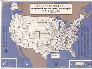
Featured Map : This 2003 Congressional Districts map shows how our country is organized politically. Have students zoom in to locate their home congressional district and the names of their local Senate and House representatives. Visit the U.S.Census 2000 site for additional census data from their state. Explore Introducing Thomas for a guide to Thomas: Legislative Information on the Internet.
Learning More: Read Data and Geographic Information Systems to learn about current methods of cartography. Access hundreds of recent maps at Maps since 1960. Find out about global positioning systems at What is a GPS?. Make sure to visit Places in the News for maps related to current events. An excellent list of current map links is available on the Reference Web Resources page. The USGS Map Page links to the National Atlas, the National Map and other topographic, thematic and planetary maps. The ESRI Map Book Gallery highlights innovative examples of GIS mapping techniques. Students can access EPA Window to My Environment interactive website and obtain environmental conditions in their own hometowns. Teachers can access the National Geographic Xpeditions for links to national standards, lesson plans, tools and interactive adventures to make geography come alive in their classrooms. Students can use the graphic organizer to analyze these maps.
|