
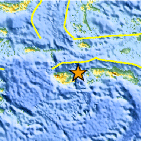
Magnitude 6.7 - SERAM, INDONESIA
2004 January 28 22:15:31 UTC
A strong earthquake occurred at 22:15:31 (UTC) on Wednesday, January 28, 2004. The magnitude 6.7 event has been located in SERAM, INDONESIA. The hypocentral depth was estimated to be 21 km (13 miles). (This event has been reviewed by a seismologist.)

Earthquake Details
| Magnitude | 6.7 |
|---|---|
| Date-Time |
Wednesday, January 28, 2004 at 22:15:31 (UTC) = Coordinated Universal Time Thursday, January 29, 2004 at 7:15:31 AM = local time at epicenter Time of Earthquake in other Time Zones |
| Location | 3.131°S, 127.420°E |
| Depth | 21 km (13 miles) |
| Region | SERAM, INDONESIA |
| Distances | 105 km (65 miles) NW of Ambon, Moluccas, Indonesia 435 km (270 miles) S of Ternate, Moluccas, Indonesia 1095 km (680 miles) NNW of Darwin, Australia 2310 km (1440 miles) E of JAKARTA, Java, Indonesia |
| Location Uncertainty | horizontal +/- 5.2 km (3.2 miles); depth +/- 7.7 km (4.8 miles) |
| Parameters | Nst=175, Nph=175, Dmin=105.6 km, Rmss=1.06 sec, Gp= 43°, M-type=teleseismic moment magnitude (Mw), Version=S |
| Source | USGS NEIC (WDCS-D) |
| Event ID | useebj |

- Preliminary Earthquake Report
- U.S. Geological Survey, National Earthquake Information Center
World Data Center for Seismology, Denver
