Woods Hole Science Center
Massachusetts Bay Disposal Site | |||||
|
Geologic Mapping Home Completed Mapping Stellwagen Bank NMS Mass Bay Disposal Site Western Mass Bay Massachusetts Bay CZM-USGS Coop Nahant-Gloucester Boston Harbor Outer Cape Cod Quicks Hole Current Mapping CZM-USGS Coop Cape Ann- Salisbury Beach Duxbury-Hull Sagamore-Duxbury Jeffreys Ledge Ocean Management Mapping Technology Bibliography of Maps Selected Links Cruises Completed Upcoming |
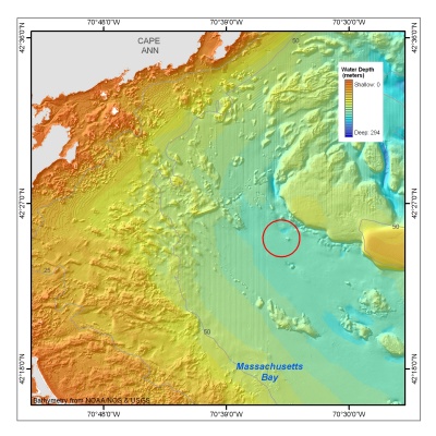
The Massachusetts Bay Disposal Site lies 17 nautical miles east of the entrance to Boston Harbor and is adjacent to the boundary of the Stellwagen Bank National Marine Sanctuary. The Site has been used as a repository for dredged material, rock debris, sunken vessels, munitions, and construction debris. The sea floor survey was conducted in April 1995 using a Simrad EM-1000 multibeam echo sounder. Cooperators: National Oceanic and Atmospheric Administration (NOAA), University of New Brunswick (UNB), Canadian Hydrographic Service (CHS)
Maps available:Interpretive map @ 1:10,000 (digital and paper) List of publications from Massachusetts Bay Disposal Site mapping | ||||