
Visiting the Sediment Retention Structure
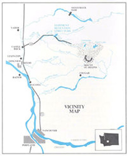 The U.S. Army Corps of Engineers welcomes visitors to view the SRS. The viewing access area is located at milepost 22 on State Route 504. Visitors can view the dam from a viewing deck or hike the mile trail and walk along the dam itself.
Though the SRS is a prime indicator of the destruction Mount St. Helens wrought on the lands, that is the only sign. Instead of rock-and-mud-covered land, you will see green grass. Instead of lifeless landscape, you may see deer and Roosevelt elk grazing, and instead of ash flying overhead, you will see eagles soaring.
For your safety, however, these signs of life must be viewed only from the marked trails and viewpoint platform.
Next page- Links about Mount St. Helens >>