|

|
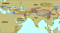
On the Road with Marco Polo: From Hormuz to Venice
Marco Polo was on the last leg of his journey home from China to Venice. After visiting several seaports in India, he and his party sailed across the Arabian Sea and to the mouth of the Persian Gulf, landing at the port city of Hormuz. Marco had visited Hormuz with his father and uncle many years before when they were on their way to China. At that time, they had considered a sea route too dangerous and decided instead to travel eastward across Asia following a land route. Perhaps they were right—by the time they arrived in Hormuz on their journey home, nearly all of the 600 people who had set out with them from China had perished! Historians attribute this to a combination of storms, disease, and combat with hostile natives encountered along the way.
After delivering the Mongol princess they were escorting to the Persian court,
the Polos trekked northward through Persia and Armenia (part of modern Turkey)
to the Black Sea.
- Go to The Silk Road.
Scroll in the margin to Maps, then Route Maps, then Marco
Polo to trace the Polos' route from Hormuz to the Black Sea. Once the
Polos reached the Black Sea, they traveled westward along the southern coast
until they arrived at the city of Constantinople (modern Istanbul). In the
13th century Constantinople was a major trading port as well a center of art
and architecture.
Student Activity:
- Access map
machine/Turkey available through Xpeditions. In what way does
the geography of this region differ from that of the land further south (modern
Iraq)?
- Go to map
machine/Istanbul available through Xpeditions. The city is located
on a strait linking it to two major bodies of water (the Mediterranean Sea
and the Black Sea). Why did this make it an ideal site for trade?
- Access Constantinople
in the Middle Ages available through Labyrinth.
In medieval times, the city was protected by high stone walls. Why did the
citizens had to worry about enemy attacks? (Think about the profits that come
from trade.)
- Go to Creation
of the Walls. How many sets of walls were built around the city?
Guiding Questions for Discussion:
- What route did the Polos take from Hormuz to Constantinople?
- What is the geography like in northern Turkey?
- What was the importance of Constantinople in medieval times?
- Can you describe the city's location?
- What were the outer walls like?
The most famous building in Constantinople was the Hagia Sophia. It remains one
of the most impressive churches in the world.
Student Activity:
Learn about the Hagia Sophia by visiting the following websites (available through
Labyrinth):
Guiding Questions for Discussion:
- What was/is the Hagia Sophia?
- How would you describe the architecture of the church?
- When was the church built?
Marco and his father and uncle boarded a trading ship in Constantinople and sailed
home to Venice. This final lap of their long journey from China was an easy voyage
on the Mediterranean Sea.
Student Activity:
- Go to Marco
Polo's Route: and follow his route from Constantinople to Venice.
- Access Europe.
Find Istanbul (Constantinople) and Venice. Trace Marco's route from Istanbul
to Venice.
Guiding Questions for Discussion:
- What ancient country did Marco sail around on the way from Constantinople
to Venice?
- What seas (small sections of the Mediterranean) did he sail through?
Assessment:
Have the students write a short essay about Constantinople. It can be illustrated
with images downloaded from the websites visited in this lesson or by original
drawings.
Selected EDSITEment Websites
Labyrinth
Xpeditions
- Marco
Polo's Return Journey
[http://magma.nationalgeographic.com/programs/splat/cgi-bin/splat.pl?URL_TRANSLATE=%2Fngm%2Fdata%2F2001%2F07%2F01%2Fhtml%
2Fmp_20010701.2.html&DB_USER=splat_ngm&DB_PASS=splat_ngm&
DB_NUM_PARAMS=2&TEMPLATE_NAME=/ngm/templates/output/
map.tmpl&DB_PARAM]
- map
machine/Turkey
[http://plasma.nationalgeographic.com/mapmachine/index.html?id=362&size=
medium&left=25.67&bottom=35.82&right=44.82&top=42.11]
- map
machine/Istanbul
[http://plasma.nationalgeographic.com/mapmachine/index.html?id=362&size=
medium&left=28.57&bottom=40.62&right=29.37&top=41.42&point=
28.9667,41.0167&text=%89stanbul]
Standards Alignment
View your state’s standards
|

