Data Download of Mercury Datasets
Fish Tissue
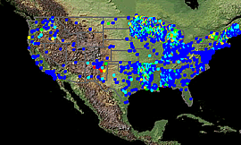 |
A database of ~35,000 fish tissue mercury records was compiled by USGS from various sources, including the following:
Selected records were required to have: a non-zero mercury concentration, valid species identifier; be identified as sampled as whole fish, skin-on fillet skin-off fillet, carcass, edible, eggs, liver, viscera (samples identified as ‘fillet’ only were rejected); and have a length measurement that is appropriate for that species. Please contact the EMMMA administrative team (emmma-admin@usgs.gov) with corrections and appropriate additions to this dataset. Please Note: These data were updated during September, 2006.
|
Point Source Emission Sites
 |
Data for point source emissions of mercury (~24,000 sites) were extracted from the U.S. Environmental Protection Agency's National Emission Inventory (NEI) database (1999 NEI Point Source Facility Summary). All NEI data and
documentation are available at:
|
Mercury Deposition Network Monitoring Sites
 |
The Mercury Deposition Network (MDN) is a network of monitoring stations under the National Atmospheric Deposition Program (http://nadp.sws.uiuc.edu/mdn/). The objective of the MDN is to develop a national database of weekly concentrations of total mercury in precipitation and the seasonal and annual flux of total mercury in wet deposition. The data will be used to develop information on spatial and seasonal trends in mercury deposited to surface waters, forested watersheds, and other sensitive receptors. This file contains a shapefile with names, coordinates, and links to data for the 81 sites currently active in the MDN.
|
Stream Sediments and Soils
 |
Mercury data for stream sediments (~33,000 samples) and soils (~11,000 samples) were extracted from the USGS's National Geochemical Survey Database at: http://tin.er.usgs.gov/geochem/
|
Mercury and Other Mine Locations
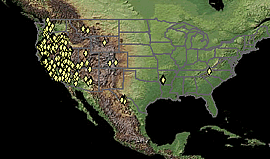 |
Data for 1100 mercury mine locations were extracted from the USGS's Minerals Availability and Mineral Industry Location Database (MAS/MILS). This coverage and associated databases contain data from selected fields of five tables in the MAS/MILS database. A separate file containing all MAS/MILS mine locations (188,000 records) is also included. For more information see:
|
Coal
 |
Mercury data for ~7,200 samples of U.S. coals were extracted from USGS's National Coal Resources Data System Coal Quality Database (COALQUAL). For more information see: .
|