Pacific Islands Water Science Center
 |
Recent Hydrologic Conditions, West HawaiiLast updated July 21, 2008 IntroductionThe West Hawaii area comprises Hualalai Volcano, the western parts of Mauna Loa and Mauna Kea Volcanoes, and the southern part of Kohala Volcano on the Big Island of Hawaii. West Hawaii has both public and private sources of potable and irrigation water. In the Waimea area, water is obtained primarily from diversions of Waikoloa and Kohakohau Streams. Elsewhere, water is obtained from ground-water wells that tap volcanic-rock aquifers. Recently, rapid population growth has placed increased demand on the water resources of the region. In collaboration with the County of Hawaii Department
of Water Supply (HDWS) and the State of Hawaii Commission
on Water Resource Management (CWRM), pumpage,
water-level, chloride-concentration, deep monitor well, streamflow, and rainfall
data for West Hawaii through the second quarter 2008 are displayed here
(click on the tabs above to see each section). Pumpage data are current through June 2008 from some users and May 2008 from others. Chloride-concentration
data are current through the end of June 2008. Rainfall data are current
through the end of May 2008. Water-level data are current through April
2008. Kahaluu deep monitor well was last profiled in November 2006. Streamflow
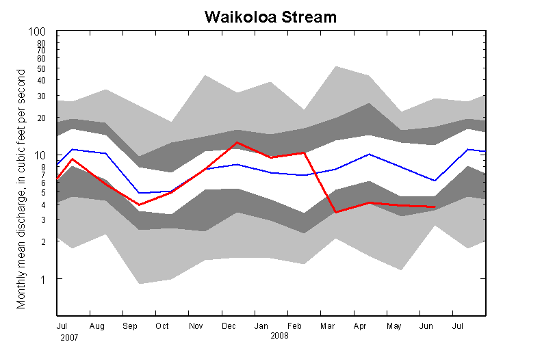
in Summary of recent conditionsThe 12-month moving mean of reported pumping in the Waimea, Anaehoomalu, Kiholo, Keauhou, and Kealakekua aquifer systems based on the most recent complete (April 2008) reported values was 9.27, 4.26, 4.38, 11.67, and 2.29 Mgal/d, respectively. These totals are from reports of 75 wells. Recent chloride concentrations were as high as 290 mg/l at Kahuluu Shaft, and 194 mg/l at Kahuluu wells. The 12-month moving means of rainfall are below the long-term means at all but one of the available rain gages used for these quarterly updates. Streamflow was below the median during April-June 2008 at the gaging station on Waikoloa Stream. Background information about West HawaiiThe West Hawaii area is characterized by a generally smooth, sloping land surface of consistent grade, marked by numerous cinder cones along the volcanic rift zones. Water erosion of the surface is nearly non-existent. Within West Hawaii, the boundaries of five aquifer systems have been defined by the Commission on Water Resource Management (1990) and Mink and Lau (1990). These are the Waimea, Anaehoomalu, Kiholo, Keauhou, and Kealakekua aquifer systems. In West Hawaii, fresh ground water tends to move from the mountainous interior of the island toward the coast and to the ocean. Ground water is withdrawn from areas: (1) near the coast, where a thin, shallow lens of freshwater or brackish water floats on denser saltwater within highly permeable lavas and (2) inland farther than about 2 to 5 miles, where fresh ground water is partially impounded by lower overall aquifer permeability and exists at altitudes greater than about 25 ft above mean sea level. No perennial streams exist in West Hawaii, except on the southern slopes
of Kohala Volcano. However, these streams rapidly lose their water downslope
of Waimea and flow to the ocean only during heavy rain events. Additional information about West Hawaii can be found in: Geohydrology and numerical simulation of the ground-water flow system of Kona, island of Hawaii: U.S. Geological Survey Water Resources Investigations Report 99–4073, 70 p. by Oki, D.S., 1999. "Preliminary report on the water resources of the Kona Area, Hawaii", Department of Land and Natural Resources, Division of Water and Land Development, Circular C46, 22 p. by D.A. Davis and George Yamanaga, 1968. "Preliminary report on the water resources of Kohala Mountain and Mauna Kea, Hawaii", Department of Land and Natural Resources, Division of Water and Land Development, Circular C14, 44 p. by D.A. Davis and George Yamanaga, 1963. References: Commission on Water Resource Management, 1990, Water Resources Protection Plan: prepared by George A.L. Yuen and Associates, Inc., for Department of Land and Natural Resources, State of Hawaii, 262 p. Mink, J.F., and Lau, L.S., 1990, Aquifer identification and classification
for Maui: groundwater protection strategy for Hawaii: Honolulu, Hawaii, University
of Hawaii Water Resources Research Center, Technical Report no. 185, 47 p. RainfallData provided by the Hawaii State Climate Office at the University of Hawaii at Manoa Meteorology Department and the National Weather Service (NWS). 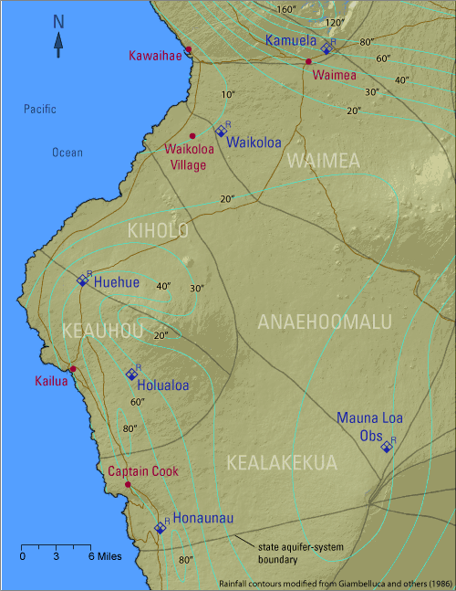
IntroductionAnnual rainfall varies considerably within the West Hawaii area. Highest rainfall occurs about five miles inland of the coast along the western slope of Mauna Loa and the southwestern slope of Hualalai, between altitudes of 2,000 and 3,000 ft. Mean annual rainfall in this band is about 80 in. Because the main rainfall-producing mechanism in this area of West Hawaii is related to the convergence of sea breeze and the tradewinds, which are most persistent in the summer, rainfall is greatest in the summer months (Giambelluca and others, 1986). This is in contrast to the rest of West Hawaii and most of the other areas of the State which have wet winters and dry summers. Lowest annual rainfall occurs at the coast, between Waikoloa and Kawaihae, where mean annual rainfall is less than 10 in. Six rainfall stations are presented here. Station 27, Honaunau, at an altitude
of 1,090 ft, includes rainfall data for 1938-present. Station 39, Mauna Loa
Observatory, at an altitude of 11,145 ft, includes data for 1955-present.
Station 70, Holualoa, at an altitude of 3,220 ft, includes data for 1919-present.
Station 92.1, Huehue, at an altitude of 1,960 ft, includes data for 1919-present.
Station 95.8, Waikoloa, at an altitude of 970 ft, includes data for 1975-present,
and Station 201.2, Kamuela, at an altitude of 2,880 ft, includes data for
1993-present. References:Giambelluca, T.W., Nullet, M.A., and Schroeder, T.A., 1986, Rainfall atlas
of Hawai‘i: Hawai‘i Department of Land and Natural Resources,
Division of Water and Land Development Report R76, 267 p. Summary of recent conditionsRain-gage data are current through May for all stations but Mauna Loa Observatory which is current through April. The 12-month moving means of rainfall are below the long-term means at two of the three gages with complete records for the last 12 months. The 12-month moving mean is about 79 percent of the long-term mean (63 in/yr) at Holualoa. The 12-month moving mean is about 105 percent of the long-term mean (48 in/yr) at Honaunau. The 12-month moving mean at Kamuela (44 in/yr)is not available due to some missing recent data. The 12-month moving mean at Huehue (36 in/yr) is not available due to some missing recent data. The 12-month moving mean (through April) is about 94 percent of the long-term mean (19 in/yr) at Mauna Loa Observatory. The 12-month moving mean is about 99 percent of the long-term mean (12 in/yr) at Waikoloa.
Twelve-month moving mean of rainfall as a percentage of long-term mean
rainfall at Holualoa, Honaunau, Huehue, Mauna Loa, Waikoloa, and Kamuela
rain gages, 1985 to present. Pumpage in aquifer systemsPumpage data provided by the County of Hawaii Department of Water Supply (HDWS) and the State of Hawaii Commission on Water Resource Management. 
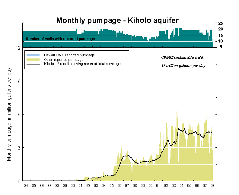
IntroductionIn 1967, the HDWS began pumping ground water in West Hawaii to supply the Kona Water System. Since then, the population and associated demand for ground water has increased greatly. In 1980, HDWS pumped about 5.3 Mgal/day from West Hawaii wells. By 2006, pumping by HDWS and other, private entities had increased to about 34 Mgal/day. In 1990, the State of Hawaii Commission on Water Resource Management established sustainable yield estimates for each of the aquifer systems (Commission on Water Resource Management, 1990). For the Waimea aquifer system, the sustainable yield value is 24 Mgal/d. For the Anaehoomalu aquifer system, the sustainable yield value is 30 Mgal/d. For the Kiholo aquifer system, the sustainable yield value is 18 Mgal/d. For the Keauhou and Kealakekua aquifer systems, the sustainable yield value is 38 Mgal/d. Records show that no aquifer system has ever been pumped at more than one-half of the State's sustainable yield value. The HDWS maintains municipal water systems that serve the Kawaihae, Waikoloa, Waimea, and Kailua areas. Various private water companies also supply ground water, primarily to resort and ranch properties, in areas not serviced by the county systems. Major private water companies include Huehue Ranch, Hualalai Development, Mauna Lani Resort, Waikoloa Water, and Waikoloa Resort Utilities. Water-use reporting is generally incomplete based on CWRM records. The maximum number of wells that have historically reported pumpage is lower than the number of production wells listed in CWRM's well database. Reasons for this difference include lack of required reporting, discontinued use of wells, and pumpage lower than required reporting limits (Information from HDWS Water Use and Development Plans). The number of wells, number of wells with historically reported data (1980—present), and the most recent number (through April 2008) of wells with reported data for each aquifer system are:
Summary of recent conditionsThis summary is based on reported pumpage records available from the State of Hawaii Commission on Water Resource Management. Latest reporting dates are listed below: HDWS last reported April 2008 The 12-month moving mean of reported pumping in the Waimea aquifer system as of April 2008 was 9.27 Mgal/d, a decrease of 0.64 Mgal/d relative to the 12-month moving mean from the previous year. The 12-month moving mean of reported pumping in the Anaehoomalu aquifer
system as of April 2008 was 4.26 Mgal/d, a decrease of 0.8 Mgal/d relative
to the 12-month moving mean from the previous year. The 12-month moving mean of reported pumping in the Kiholo aquifer system as of April 2008 was 4.38 Mgal/d, an increase of 0.4 Mgal/d relative to the 12-month moving mean from the previous year. The 12-month moving mean of reported pumping in the Keauhou aquifer system as of April 2008 was 11.67 Mgal/d, a decrease of 1.04 Mgal/d relative to the 12-month moving mean from the previous year. The 12-month moving mean of reported pumping in the Kealakekua aquifer
system as of April 2008 was 2.29 Mgal/d, a decrease of 0.01 Mgal/d relative
to the 12-month moving mean from the previous year. References: Commission on Water Resource Management, 1990, Water Resources Protection Plan: prepared by George A.L. Yuen and Associates, Inc., for Department of Land and Natural Resources, State of Hawaii, 262 p.
West Hawaii number of wells with reported pumpage, reported pumpage, and 12-month moving mean of total pumpage, 1984 to present.
Waimea aquifer system number of wells with reported pumpage, reported pumpage, and 12-month moving mean of total pumpage, 1984 to present. 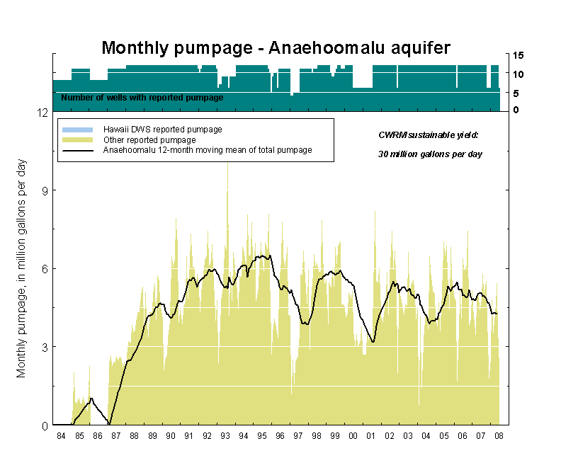
Anaehoomalu aquifer system number of wells with reported pumpage, reported pumpage, and 12-month moving mean of total pumpage, 1984 to present.
Kiholo aquifer system number of wells with reported pumpage, reported pumpage, and 12-month moving mean of total pumpage, 1984 to present.
Keauhou aquifer system number of wells with reported pumpage, reported pumpage, and 12-month moving mean of total pumpage, 1984 to present.
Kealakekua aquifer system number of wells with reported pumpage, reported pumpage, and 12-month moving mean of total pumpage, 1984 to present. Table 1. Reported pumpage, in million gallons per day, for aquifer systems in West Hawaii Island, Hawaii, May 2007-April 2008.
Note: 12-month moving mean is the mean of the monthly pumpage values for a given month and the previous 11 months; Totals in bold are incomplete when pumping data from the State of Hawaii Commission on Water Resource Management does not include all known wells in the aquifer system. Water levels in wellsData collected by the U. S. Geological Survey in cooperation with the State of Hawaii Commission on Water Resource Management. Data after September 30, 2006 are provisional and subject to revision. 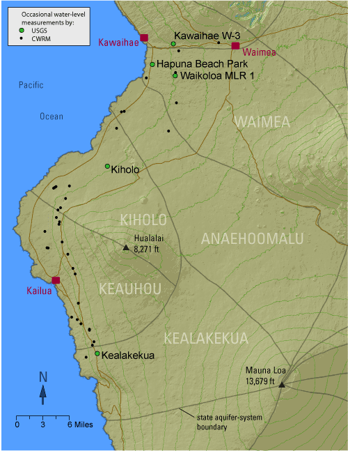 Fresh
ground water in West Hawaii is found in two main forms: (1) as a lens-shaped
body of freshwater, called a freshwater lens, floating on denser, underlying
saltwater within permeable lava flows near the coast, and (2) as water impounded
to high levels within the inland part of the aquifer with lower overall permeability
(high-level ground water). Freshwater in the highly permeable lava flows near
the coast exists in only the upper part of the aquifer, and in only a small
fraction of the total thickness of the aquifer. Fresh ground water flows from
the inland area to coastal discharge areas. Because the volcanic rocks are
highly permeable and crop out offshore, freshwater can readily discharge to
the ocean, ground-water levels are relatively low (generally less than 10 ft
above sea level and commonly less than 5 ft above sea level), and saltwater
can readily enter the aquifer. In areas near the coast where saltwater mixes
thoroughly with seaward-flowing freshwater, a freshwater lens may not form
and brackish water may exist immediately below the water table. Fresh
ground water in West Hawaii is found in two main forms: (1) as a lens-shaped
body of freshwater, called a freshwater lens, floating on denser, underlying
saltwater within permeable lava flows near the coast, and (2) as water impounded
to high levels within the inland part of the aquifer with lower overall permeability
(high-level ground water). Freshwater in the highly permeable lava flows near
the coast exists in only the upper part of the aquifer, and in only a small
fraction of the total thickness of the aquifer. Fresh ground water flows from
the inland area to coastal discharge areas. Because the volcanic rocks are
highly permeable and crop out offshore, freshwater can readily discharge to
the ocean, ground-water levels are relatively low (generally less than 10 ft
above sea level and commonly less than 5 ft above sea level), and saltwater
can readily enter the aquifer. In areas near the coast where saltwater mixes
thoroughly with seaward-flowing freshwater, a freshwater lens may not form
and brackish water may exist immediately below the water table.
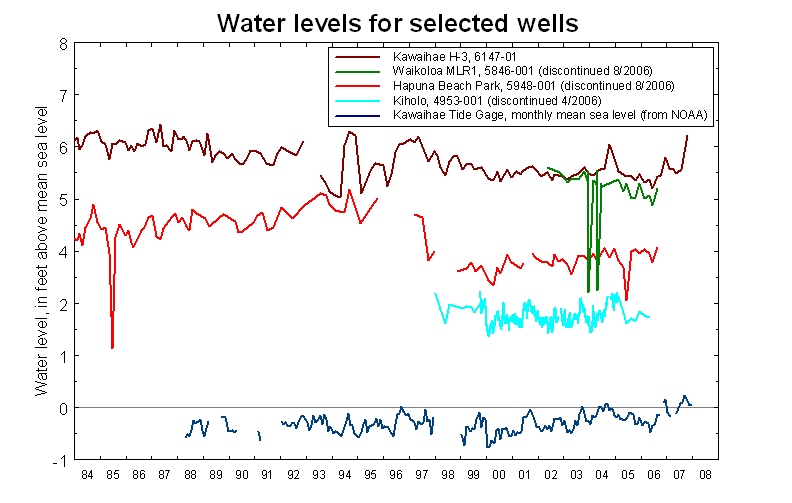
Within the high-level ground-water area, which occurs at distances greater than about 2 to 5 miles inland from the coast, low-permeability rocks compartmentalize the more permeable rocks, resulting in ground water being impounded to high altitudes. Because of this compartmentalization of the aquifer, water levels can change by hundreds of feet over horizontal distances of less than a mile. The source of freshwater in the high water-level area is ground-water recharge from (1) infiltration of rainfall and fog drip and (2) irrigation water. Fresh ground water in the high water-level area that is not withdrawn from wells flows to downgradient areas where water levels are lower and where a freshwater lens may exist. Currently, the USGS measures water levels about six times per year in one well in West Hawaii, Kawaihae W-3 (well 6147-01). The Kawaihae W-3 well is located in the Waimea aquifer system. The well was drilled for the State of Hawaii in 1963 and water-level measurements have been made on a regular basis (about every two to three months) since 1975. In 2006, long-term water-level monitoring in four other USGS wells in West Hawaii was discontinued. These wells are: Kealakekua (well 3155-01), Kiholo (well 4953-01), Waikoloa MLR 1 (well 5846-01), and Hapuna Beach Park (well 5948-01). In 1991, the State of Hawaii Commission on Water Resource Management started a ground-water monitoring program that involves occasional water-level measurements at 40 private and public wells in West Hawaii. A 2003 study by the State of Hawaii summarized the results of this program through 2002. Occasional measurements continue to be made at a number of these wells.
Additional information about ground water in West Hawaii can be found in: Geohydrology and numerical simulation of the ground-water flow system of Kona, island of Hawaii: U.S. Geological Survey Water Resources Investigations Report 99–4073, 70 p. by Oki, D.S., 1999.
Water-level records for Kawaihae H-3, Waikoloa MLR1, Hapuna Beach Park, and Kiholo wells and the monthly ocean level at Kawaihae Harbor, 1984 to the present.
Salinity of ground water (including chlorides in pumped water and transition-zone fluid conductivity)Chloride data provided by the State of Hawaii Commission on Water Resource Management and the County of Hawaii Department of Water Supply. 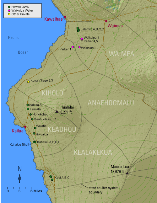
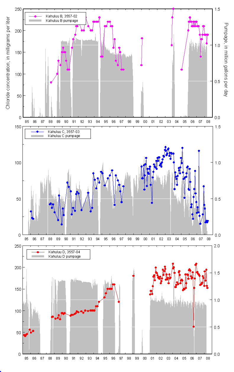
Chloride concentration of pumped waterChloride concentration is generally used as an indicator of saltwater intrusion into the ground-water system. Changes in chloride concentration of pumped water over time can be a function of the pumping rate of a particular well, pumping at nearby wells, and recharge to the aquifer. Therefore, the evaluation of aquifer conditions based on chloride-concentration trends from the pumped wells has limitations. In West Hawaii, chloride concentrations in many of the pumped wells near the coast appear to increase directly in response to increased pumping at those wells. For some drinking-water wells in West Hawaii, chloride concentration of
the pumped water has been above the USEPA
secondary maximum contaminant level of 250 mg/L for drinking water. Chloride
concentrations have been as high as 1,100 mg/L in the Kona Village wells.
Chloride concentrations have commonly exceeded
250 mg/L in the Kahaluu Shaft and Keei wells operated by HDWS. Summary of recent conditionsRecent chloride concentration data are currently only available for some HDWS wells. At Keei D, recent chloride concentrations were between 3 and 4 mg/l. At Kahuluu, recent chloride concentrations were between 120 and 290 mg/l in Kahuluu Shaft, between 152 and 194 mg/l in Kahuluu B and D, between 82 and 99 mg/l in Kahuluu A, and between 17 and 19 mg/l in Kahuluu C. At Holualoa, recent chloride concentrations were between 150 and 170 mg/l. At the Kona area high-level wells, recent chloride concentrations are all lower than 15 mg/l.
Chloride concentrations and monthly pumpage for Keei well field, 1985 to present.
Chloride concentrations and monthly pumpage for Kahuluu well field, 1985 to present. 
Chloride concentrations and monthly pumpage for Holualoa well, 1985 to present. 
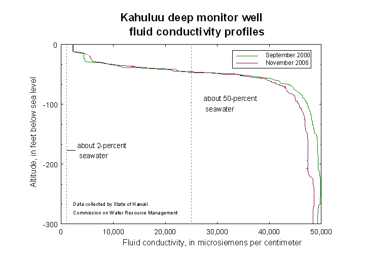
Chloride concentrations and monthly pumpage for Kona area high-level wells, 1985 to present. Kahaluu deep monitor wellKahuluu deep monitor well data collected by the State of Hawaii Commission on Water Resource Management.
| ||||||||||||||||||||||||||||||||||||||||||||||||||||||||||||||||||||||||||||||||||||||||||||||||||||||||||||||||||||||||||||||||||||||||||||||||||||||||||

|
|||||||||||||||||||||||||||||||||||||||||||||||||||||||||||||||||||||||||||||||||||||||||||||||||||||||||||||||||||||||||||||||||||||||||||||||||||||||||||

 formation
is updated through March 2008.
formation
is updated through March 2008.


 Introduction