Coastal and Marine Geology Program
|
|
| Coastalmap Home / CMGP Internet Map Server / WHSC Core and Sample IMS / WHSC Field Activities IMS / GLORIA Mapping Program / GIS Data Publications |
|
|
|
|
U.S. Geological Survey
|
 |
|||||||||||||||
U.S. EEZ Gulf of Mexico Region GLORIA Mapping ProgramDigital Mosaic of the GLORIA data of the Gulf of Mexico |
Download On-line Digital GLORIA Mosaics GLORIA Internet Map Servers CMGP Science Centers |
|||||||||||||||
|
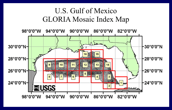
BackgroundIn the late summer and fall of 1985, the USGS conducted surveys of the Exclusive Economic Zone (EEZ) in the Gulf of Mexico and around Puerto Rico and the U.S. Virgin Islands. The 1985 survey abutted an area surveyed in 1982 as part of the Outer Continental shelf geohazards work that focused on the Texas-Louisiana continental slope and preliminary work for the Deep Sea Drilling Project in the Mississippi Fan. The collected GLORIA data was processed and digitally mosaicked to produce continuous imagery of the seafloor. The 1982 and 1985 datasets were combined to produce sidescan coverage of the EEZ in the Gulf of Mexico. A total of 16 digital mosaics of a 2 degree by 2 degree (or smaller) area with a 50 meter pixel resolution were completed for the Gulf of Mexico. The individual mosaics were later combined to produce an overview of the Gulf of Mexico. A reduced version of the completed digital mosaic of the Gulf of Mexico is provided here.
Mosaic Index MapReduced images (250 meter resolution) of the individual 16 mosaics are also available for viewing from the following index map. Full resolution imagery (50 meter pixels) is available on-line or from CD-ROM. Please note the Digital Data listed in the GLORIA Publications and References list.Full resolution imagery (50 meter pixels) are available from various CD-ROM publications or may be downloaded online. Please note the Digital Data citations listed in the GLORIA Publications and References list for released datasets.
Geologic Interpretation
Publications and ReferencesInformation contained in these pages have been summarized from a variety of sources. More detailed descriptions of the EEZ, GLORIA program and sidescan sonar system, data processing and mosaicking techniques, and geologic interpretations may be obtained from previously published sources. A few of these sources have been listed here. |
|||||||||||||||

![]() U.S. Department of the Interior |
U.S. Geological Survey
U.S. Department of the Interior |
U.S. Geological Survey
URL: http://coastalmap.marine.usgs.gov/gloria/gomex/index.html
Page Contact Information: jomalley@usgs.gov
Page Last Modified: Tuesday, May 01, 2007, 07:41 AM

;)
;)
;)
;)
;)
;)
;)
;)
;)
;)
;)
;)
;)
;)
;)
;)
;)
;)
;)
;)