|
|||
|
The geology of an area has a profound effect on many things, from the likelihood of landslides, to the availability of groundwater in wells, from the amount of shaking suffered in an earthquake, to the presence of desirable minerals, from the way the landscape is shaped to the kinds of plants that grow best there. Understanding the earth underneath is the first step in understanding the world around us. So what's the geology like in your neighborhood? If you can read a geologic map you can find out! |
|||
|
What is a Geologic Map?
Geologic maps are not like other maps. Geologic maps, like all maps, are designed to show where things are. But, whereas the maps we know best show the distribution of roads or rivers or county boundaries, a geologic map shows the distribution of geologic features, including different kinds of rocks and faults. A geologic map is usually printed on top of a regular map (called a base map) to help you locate yourself on the map. The base map is printed with light colors, so it doesn't interfere with seeing the geologic features on the map. The geology is represented by colors, lines, and special symbols unique to geologic maps. Understanding these features will allow you to understand much of the geology shown in almost any standard geologic map. |
|||
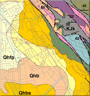 Colored Areas
The most striking features of geologic maps are its colors. Each color represents a different geologic unit. A geologic unit is a volume of a certain kind of rock of a given age range. So a sandstone of one age might be colored bright orange, while a sandstone of a different age might be colored pale brown. Many geologic units are given names that relate to where their characteristics are best displayed, or where they were first studied. For example, the Briones sandstone was first described in Briones Valley,California. Some geologic units have not yet been named, so those are identified with terms related to the kind of rock in the unit like 'Sandstone and shale,' 'Unnamed sandstone', or 'Undivided shale'. But all units, named and unnamed, have a color on the geologic map, and the area of a given color is the area where that geologic unit is the one at the surface (usually the soil on top of the rocks is disregarded). Geologic units are named and defined by the geologists who made the geologic map, based on their observations of the kinds of rocks and their investigations of the age of the rocks. As more information is gathered, perhaps by other geologists, new geologic units might be defined. These disagreements can be a basis for scientific progress, and illustrate the need for continuing to investigate the geology of an area. To see the full geologic map (160 KB) for this site, click here Continue to Map Symbols |
|||
|
| What is a geologic map? |
Colors |
Letter symbols |
| Lines | Faults | Strike and dip | Map key | |

|
| |
| | |