|
|
|
Metadata
|
|
ID
|
06SCC03
|
|
Also Known As
|
DS 311
G306LA
G-3-06-LA
BICM
|
|
Abstract
|
United States Geological Survey, St. Petersburg, Florida.
Chief Scientist: Nick Ferina. Geophysical data
(subbottomprofiler, EdgeTech, DGPS) of field activity 06SCC03
(G-3-06-LA) in Offshore of Cheniere Caminada, Louisiana from
07/18/2006 to 07/20/2006
|
|
Organization
|
United States Geological Survey, St. Petersburg, Florida
|
|
Project/Theme
|
Subsidence and Coastal Change (SCC)
|
|
Chief Scientist
|
Nick Ferina
|
|
Activity Type
|
Geophysical
|
|
Platform
|
Gilbert
|
|
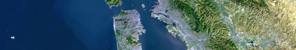
Area of Operation
|
Offshore of Cheniere Caminada, Louisiana
|
|
Location map
|

|
|
Bounding Coordinates
|
29.17837
-90.22405 -90.03865
29.05017
|
|
Ports
|
LEAVE Grand Isle, LA
ARRIVE Grand Isle, LA
|
|
Dates
|
07/18/2006 (JD 199) to 07/20/2006 (JD 201)
|
|
Analog Materials
|
list
|
|
Scanned Materials
|
G-3-06-la.science log (pdf)
|
|
Index map

|
|
|
Information Specialist
|
|
|
Crew
|
|
Nick Ferina
|
Chief Scientist, USGS
|
|
Dana Wiese
|
electronics tech, USGS
|
|
Dave Bennett
|
boat Captain, USGS
|
|
|
Equipment Used
|
|
subbottomprofiler
|
|
EdgeTech
|
|
DGPS
|
|
|
Purpose
|
|
|
Information to be Derived
|
|
ASEMENT)
|
|
Post-Hurricane Katrina Barrier Island Coastal Monitoring
|
|
|
Summary
|
|
|
Notes
|
|
Digital 06SCC03 FACS logs were generated by A.
|
|
Harrison in August of 2006 using the handwritten logs
|
|
and personal accounts of the crew members.
|
|
BICM Barrier Island Coastal Monitoring
|
|
|
Publications
|
|
Harrison, A.S., Dadisman, S.V., Ferina, N.F., and Wiese, D.S., 2007, Archive
|
|
of Digital CHIRP Seismic Reflection Data Collected During USGS Cruise 06SCC03
|
|
Offshore of Cheniere Caminada, Louisiana, July 2006, U.S. Geological Survey
|
|
Data Series 311
|
|
|
Got Help?
|
For 06SCC03, we would appreciate any information on -- contract, days at sea, dive count, funding, kms of navigation, national plan, NGDC Info, owner, project number, scanned materials, seismic description, station count, station description, submersible, tabulated info.
|
|