
USGS/Cascades Volcano Observatory, Vancouver, Washington
Mount Hood, Oregon
Maps and Graphics
-
 [Interactive Imagemap] ...
[Map,150K,GIF] ...
[Interactive Imagemap] ...
[Map,150K,GIF] ...
Cascade Range Volcanoes
-- Graphic by: Lyn Topinka, 1996
-
 [Map,20K,InlineGIF]
Major West Coast Volcanoes - Washington, Oregon, and California
-
 [Map,27K,InlineGIF]
Potentially Active Volcanoes of the Western United States
-- Modified from: Brantley, 1994, Volcanoes of the United States:
USGS General Interest Publication
-
 [Graphic,70K,InlineGIF]
Cascades Eruptions During the Past 4000 Years
-

Seismic Monitoring at Cascade Volcanic Centers - The Big Picture
Informational text and shaded relief map
showing locations of all PNSN/NCSN seismic stations operating in the Pacific Northwest as of November, 2003. Map includes the 13 major Cascade volcanic centers.
-- Excerpt from: Moran, 2005, USGS Scientific Investigations Report 2004-5211
-
 [Map,20K,InlineGIF]
Southwest Washington - Northwest Oregon
-- includes Mounts Rainier, St. Helens, Adams, and Hood
-- Modified from: Doukas, 1990, USGS Bulletin 1859
-
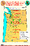
 [Map,22K,InlineGIF]
Location Map, Mount Hood Vicinity, Portland, and
Vancouver
-- Modified from: Brantley and Scott, 1993
-
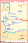
 [Map,25K,InlineGIF]
Mount Hood and Vicinity
-- Modified from: Swanson, et.al., 1989,
AGU Field Trip Guidebook T106
-
 [Map,12K,GIF]
Simplified Map - Glaciers of Mount Hood, Oregon
-- Modified from: Swanson, et.al., 1989,
AGU Field Trip Guidebook T106
-
 [Graphic,20K,InlineGIF]:
Key Geologic Events in the Mount Hood Region During the Past
30,000 Years
-- Modified from: Scott, et.al., 1997, USGS Open-File Report 97-89
-
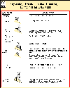
 [Graphic,22K,GIF]
Volcanic hazards at Mount Hood related to growth of a lava dome
-- From: Brantley and Scott, 1993
-
 [Graphic,22K,GIF]
Volcanic Hazards at Mount Hood
related to growth of a lava dome near Crater Rock
-- From: Brantley and Scott, 1993
-
Seismic Monitoring at Cascade Volcanic Centers - The Big Picture
Informational text and shaded relief map
showing locations of all PNSN/NCSN seismic stations operating in the Pacific Northwest as of November, 2003. Map includes the 13 major Cascade volcanic centers.
-- Excerpt from: Moran, 2005, USGS Scientific Investigations Report 2004-5211
-
 [Map,40K,InlineGIF]
University of Washington's Pacific Northwest Seismic Network
-- Modified from: University of Washington Geophysics Program, 1998,
includes seismic station location map and link to PNSN
-
 [Map,30K,InlineGIF]
Oregon and Southern Washington -
University of Washington's Pacific Northwest Seismograph Network
-- Modified from: University of Washington Geophysics Program, 1999,
includes seismic station location map and link to PNSN
-
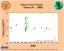
 [Graphic,19K,InlineGIF]
Mount Hood Seismicity, 2007
-- Modified from: University of Washington Geophysics Program
-
 [Graphic,19K,InlineGIF]
Mount Hood Seismicity, 2006
-- Modified from: University of Washington Geophysics Program
-
 [Graphic,19K,InlineGIF]
Mount Hood Seismicity, 2005
-- Modified from: University of Washington Geophysics Program
-
 [Graphic,21K,InlineGIF]
Mount Hood Seismicity, 2004
-- Modified from: University of Washington Geophysics Program
-
 [Graphic,21K,InlineGIF]
Mount Hood Seismicity, 2003
-- Modified from: University of Washington Geophysics Program
-
 [Graphic,21K,InlineGIF]
Mount Hood Seismicity, 2002
-- Modified from: University of Washington Geophysics Program
-
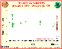
 [Graphic,20K,InlineGIF]
Mount Hood Seismicity, 2001
-- Modified from: University of Washington Geophysics Program
-
 [Graphic,20K,InlineGIF]
Mount Hood Seismicity, 2000
-- Modified from: University of Washington Geophysics Program
-
 [Graphic,20K,InlineGIF]
Mount Hood Seismicity, 1999
-- Modified from: University of Washington Geophysics Program
-
 [Graphic,15K,InlineGIF]
Mount Hood Seismicity, 1998
-- Modified from: University of Washington Geophysics Program
-
 [Graphic,25K,InlineGIF]
Mount Hood Seismicity, 1998-2007
-- Modified from: University of Washington Geophysics Program
-
 [Graphic,25K,InlineGIF]
Mount Hood Seismicity, 1990-1999
-- Modified from: University of Washington Geophysics Program
-
 [Image,96K,InlineJPG]
Annotated NASA Image:
Looking South at the
Three Sisters, Mount Jefferson, and Mount Hood, Oregon, August 1985.
-- NASA Photo, courtesy
NASA Earth From Space;
Modified with text by USGS/CVO.
-
 [Image,97K,InlineJPG]
Looking West at Mount Hood, Oregon, the Columbia River, and Mount St. Helens and Mount Adams, Washington,
September 1994
-- NASA Photo, courtesy NASA Earth From Space;
Modified with text by USGS/CVO.
Return to:
[Mount Hood Menu] ...
[Mount Hood Eruptive History Menu] ...
[MORE Cascade Range Maps and Graphics]
[MORE Oregon Maps and Graphics]
[MORE Annotated NASA Images]

Use of CVO Material and Copyright Information
URL for CVO HomePage is:
<http://vulcan.wr.usgs.gov/home.html>
URL for this page is:
<http://vulcan.wr.usgs.gov/Volcanoes/Hood/Graphics/framework.html>
If you have questions or comments please contact:
<GS-CVO-WEB@usgs.gov>
09/02/08, Lyn Topinka
 [Map,12K,GIF]
 [Graphic,22K,GIF]
 [Graphic,22K,GIF]