USGS/CVO Logo, click to link to National USGS Website
USGS/Cascades Volcano Observatory, Vancouver, Washington

Mount Hood, Oregon
Seismicity - Time vs. Depth
1999


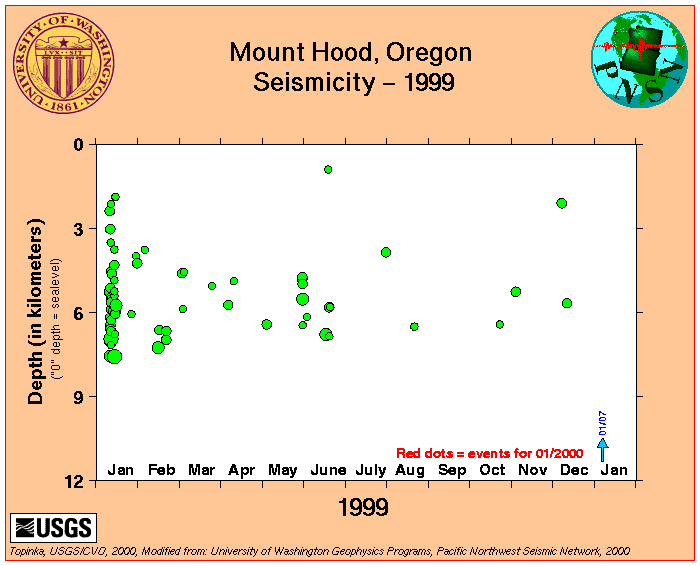
A Swarm of earthquakes began at Mount Hood on January 11, 1999. A current list of earthquakes in the swarm is available. In general the earthquakes occurred about 4 miles (7 kilometers) south-southeast of Mount Hood near the Mount Hood Meadows ski area. Several magnitude 3 earthquakes have occurred in the swarm. The largest earthquake in this area in the last 30 years was a magnitude 4 earthquake on December 13, 1974. The approximate location of earthquakes in the January, 1999 swarm is 45.3195N 121.6538W.

Click button for USGS Information Statement, January 14, 1999 January 14, 1999 Information Statement


Plot, Mount Hood Seismicity, 1999


Return to:
[Mount Hood Earthquakes and Seismicity Menu] ...
[Mount Hood Menu] ...

Link to:
[University of Washington Geophysics Program, Pacific Northwest Seismic Network's Mount Hood Page] ...


CVO HomePage Volcanoes of the World Menu Mount St. Helens Menu Living With Volcanoes Menu Publications and Reports Menu Volcano Monitoring Menu Servers and Useful Sites Menu Volcano Hazards Menu Research and Projects Menu Educational Outreach Menu Hazards, Features, and Terminology Menu Maps and Graphics Menu CVO Photo Archives Menu Conversion Tables CVO Index - Search Our Site ButtonBar

Use of CVO Material and Copyright Information
URL for CVO HomePage is: <http://vulcan.wr.usgs.gov/home.html>
URL for this page is: <http://vulcan.wr.usgs.gov/Volcanoes/Hood/Seismicity/Graphics/hood_seismic_plot_1999.html>
If you have questions or comments please contact: <GS-CVO-WEB@usgs.gov>
01/02/03, Lyn Topinka